


Monsen
Monsen
About
- Username
- Monsen
- Joined
- Visits
- 723
- Last Active
- Roles
- Administrator
- Points
- 9,029
- Birthday
- May 14, 1976
- Location
- Bergen, Norway
- Website
- https://atlas.monsen.cc
- Real Name
- Remy Monsen
- Rank
- Cartographer
- Badges
- 27
Latest Images


-
Setting all Symbol Catalogs to default
There isn't any restore to default feature except reinstalling. When you change the symbol catalogs, you do changes to the actual catalog and configuration files, and these are persistent. There are no "default settings" for most things in CC3+, other than to replace the various files with clean versions.
If it is just the map settings in a single map that is messed up, causing it to load wrong catalogs and tools, you need to hit :CC2PRESETS: and set the map style back to the correct style for that map type, and if you have changed the OnOpenMacro map note, revert it back to the original settings by just copying the macro commands from a fresh map in the same style.


-
Cosmographer Deckplan issues
The tools are all set up with a mirror line of 0 degrees as default which results in the ship being mirrored along the X-axis
If you wish to draw a ship withe the nose pointing up, right click :COSHULL:, look for the tool to use, note the name mentally, then hit the Advanced button and select the tool you wanted in the list to the left.
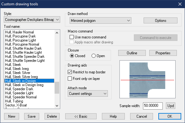
Now, hit the Options button, and set the mirror line angle to 90 degrees. (Obviosuly, this is only possible for tools that have Mirrored Polygon as the draw method)
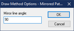
Hit OK, and then Hit OK again to start drawing. Say no when it asks you to save your changes, otherwise the tool will be permanently modified.
Then just draw your hull.


-
Cosmographer Deckplan issues
It's the snap setting. Snap and Cursor snap is on, but for some reason, no grid is selected. This basically causes everything to snap to 0,0 and nowhere else.
Right click the snap button in the lower right, and click on one of the existing snap grids in the list (or create a new one)

-
Floor Disappears
The change doesn't change anything in the actual map, just changes some parameters for how CC3+ does the rendering of it.
The setting is persistent in CC3+ until you close and reopen the program, so it will affect any maps you open in that instance of CC3+.
To always have it load for a particular map, you can put
DELAYDRAWSYM 0into the OnOpenMacro of the map file. (Obviously, this will keep it active for the lifetime of the instance and not just for that map)
-
Floor Disappears
What is happening here is that when effects are on, that background picture, which also resides on the floors sheet (it probably shouldn't bee on this sheet though), gets re-drawn on top of the floors.
This is due to an implementation of certain effects that causes symbols and other images to be redrawn and placed on top after effects have been processed. You can see there are aslo some symbol overlaps that change in your map when effects are turned on.
The simple way to fix this is to type the command
DELAYDRAWSYMon the command line, the command prompt will switch to a prompt asking if they should be enabled, then just type0and hit enter to turn this feature off.
