Monsen
Monsen
About
- Username
- Monsen
- Joined
- Visits
- 718
- Last Active
- Roles
- Administrator
- Points
- 8,999
- Birthday
- May 14, 1976
- Location
- Bergen, Norway
- Website
- https://atlas.monsen.cc
- Real Name
- Remy Monsen
- Rank
- Cartographer
- Badges
- 27
-
Bulkhead and door question - Cosmographer
Seems to work fine for me in your drawing, but notice this:
- Turn of snap when placing cutting symbols. Snaps modifies placement, which often lead to the symbol not aligning/cutting correctly
- I found at least one bulkhead in your drawing that were doubled up with two bulkheads on top of each other. The cutting symbol will only cut one, leaving the other, making it appear as if nothing were cut.
- Some of the symbols only cut the size of the actual door portion of the symbol, and not the doorframe, this can also lead to an initial appearance of not being cut until you look closer.
-
Setting all Symbol Catalogs to default
Note that if it is a single map, reinstalling will NOT help, as that won't change your map.
Just reinstalling the latest update won't help when restoring files to default, as that only replaces files contained in the update, i.e. things that have been updated since release, to restore original files you need to run the original installer (CC3+ base or add-on, depending on what you want to fix), and then re-run the latest update after doing that.
-
Setting all Symbol Catalogs to default
There isn't any restore to default feature except reinstalling. When you change the symbol catalogs, you do changes to the actual catalog and configuration files, and these are persistent. There are no "default settings" for most things in CC3+, other than to replace the various files with clean versions.
If it is just the map settings in a single map that is messed up, causing it to load wrong catalogs and tools, you need to hit :CC2PRESETS: and set the map style back to the correct style for that map type, and if you have changed the OnOpenMacro map note, revert it back to the original settings by just copying the macro commands from a fresh map in the same style.
-
Cosmographer Deckplan issues
The tools are all set up with a mirror line of 0 degrees as default which results in the ship being mirrored along the X-axis
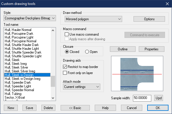
If you wish to draw a ship withe the nose pointing up, right click :COSHULL:, look for the tool to use, note the name mentally, then hit the Advanced button and select the tool you wanted in the list to the left.
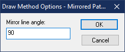
Now, hit the Options button, and set the mirror line angle to 90 degrees. (Obviosuly, this is only possible for tools that have Mirrored Polygon as the draw method)
Hit OK, and then Hit OK again to start drawing. Say no when it asks you to save your changes, otherwise the tool will be permanently modified.
Then just draw your hull.
-
Cosmographer Deckplan issues


