


Monsen
Monsen
About
- Username
- Monsen
- Joined
- Visits
- 723
- Last Active
- Roles
- Administrator
- Points
- 9,029
- Birthday
- May 14, 1976
- Location
- Bergen, Norway
- Website
- https://atlas.monsen.cc
- Real Name
- Remy Monsen
- Rank
- Cartographer
- Badges
- 27
Latest Images


-
Fighting with TRACED
I don't think TRACED can handle that image. Too much details beyond the landmass itself, like that border, all the text, all those tiny islands, city symbols extending beyond the coastline.
You'll probably have an easier time just tracing it visually (manually) using the landmass drawing tool.


-
Exporting map to jpg image - aligning grid with vtt grid
When you are exporting for VTT use and plan to use grids, make sure to always export using the rectangular section option. For example, if you look at your screenshot above, you'll notice that you have a border outside your map that is part of your image.
CC3+ isn't a "grid mapper", so export sizes are for the entire drawing, not just the gridded areas, so when you export the image in a size of 2000x2000, that border is going to eat part of that size, not leaving a full 100px for each grid square. But if you use rectangular section when you export and make sure to only export the map itself (use snaps on when defining the area to ensure precision) you should get the right size.
It is also important to set the export size correct in both dimensions.


-
Printing out high res maps
It is worth noting that a single image file really cannot contain as much detail as the original CC3+ map, unless it is a very small map.
This is just a limit of images, really. While you can certainly export an image large enough that you can do zooms in it, you can't get the same quality as inside CC3+ itself.
If you are interested in very large exports, you can have a look at the large exports annual, it contains scripts that help you do what Sue suggests, export in pieces and stitch together, but as she says, you still quickly runs into issues with the image formats themselves.
I have done a 200000 x 200000 pixel export using this technique, but the image file is basically unusable, no programs actually manage to open that file. The only thing I could do with it was creating a zoomable web view (Go to https://atlas.monsen.cc/Maps/City%20Of%20Sanctuary and hit the "Zoomable Image" button). It is quite impressive, but of limited use.
-
Community Atlas - Forlorn archipelago - The Bleakness, 2 villages and 2 keeps
I've always found it best to just think about what you have good ideas for. A map always ends up best if it starts with a good idea, rather than just start with a random area. So just go through the map in your head, think a little about what you would put there if making a map. Then decide if you have a good enough idea for the larger area or not.

-
[WIP] Greco-Roman Inspired Temple
Mappy Birthday!
It's a very nice temple. I don't think I particularly prefer any of the roof or offering options. They all look nice.
My main issue with the map is the grass around it. The scaling makes it look very repetitive. I would consider changing the scale of it a bit, and perhaps try to fill out the areas a bit so you don't get those large unbroken areas of plain grass. That do apply a bit to the paving around the temple area as well, perhaps change the scale so they don't repeat quite as much.
-
Cosmographer Traveller sector problem
It's caused by travellermap outputting colors in html code format, something it didn't do when the tool was written.
See this topic (from the linked post and onwards, the posts from this year) for some more information and workaround.
-
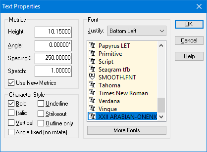
Help with Fonts
List should provide you with the actual font used. CC3+ uses Arial as a replacement font, so if it shows Calligraphic, that's the actual font used.
See here for an example from my own system where I am missing the font used in the map:
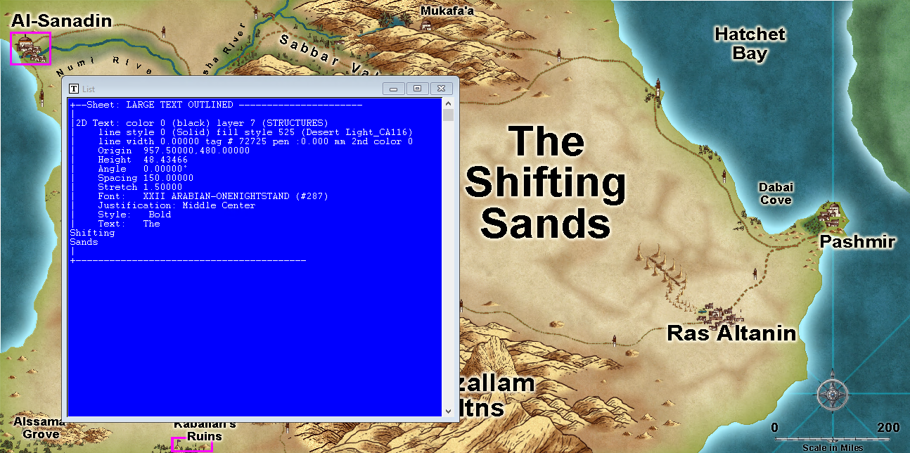
As you can see, it correctly identifies it even if it is displayed using Arial.
There is also another way to see what fonts are defined in a map though, just hit :CC2TSPEC:, the dialog shows all the font referenced from the map. You can't see what font is used for what text from here, and it shows all the fonts defined in the map, which doesn't mean you have actually used them, but it should be enough to help.
-
How much difference between the User Guide 03-15 and 12-17? (Remy?)
Not much. Mainly a new short chapter describing the Symbols along, fill with symbols, and symbols in area.

-
Where are bitmaps 'CA51' please
The reason you couldn't find them is because they don't have CA51 in the file name. If you look in Sue's screenshot above, you'll see that the 'Dunes CA51' fill references a bitmap called 'Dunes.png'
That's why you can find them using that dialog, but you need to do so from a map in the appropriate style. From there you can find their names, and then in the map you want them in, you can then easily add them once you have learned that filename.

-
Live Mapping - Sinister Sewers
Sue has made a new style designed to truly get our minds down into the gutter (and below), so it is time to show it off.
Follow us on the live stream where we will tackle Sue's Sinister Sewers and their Secrets.
As usual, you should see the time in your timezone in the forum sidebar, or just head over to YouTube and Google will happily tell you.
