


Monsen
Monsen
About
- Username
- Monsen
- Joined
- Visits
- 723
- Last Active
- Roles
- Administrator
- Points
- 9,029
- Birthday
- May 14, 1976
- Location
- Bergen, Norway
- Website
- https://atlas.monsen.cc
- Real Name
- Remy Monsen
- Rank
- Cartographer
- Badges
- 27
Latest Images


-
multiple map borders possible?
The map border is just an entity like everything else. You can more or less do what you want.
When talking about the map border though, it is important to remember that there are two of them, the "technical" map border which consists of 4 lines on the MAP BORDER layer, and defines the actual size of the map and the stopping point for things like drawing tools. Then you have the visual/graphical map border, which is just decoration.
For decorative map borders, you can create as many as you want, and shape them as you want. But the drawing can only have 1 technical map border (the 4 lines around the outside of the map), and that one needs to be rectangular, no weird shapes. Now, you don't technically need a technical map border at all, but without one, you're drawing tools don't have a border to snap to, and you can't use the resize drawing area command. Also, exporting and printing to map border won't work, you will always have to define areas yourself, but technically, these are just conveniences, not requirements.


-
Map Construction
Templates have different advantages and disadvantages. Generally, all maps with particularily "fancy" elements have constrained dimensions because the new map wizard doesn't have the facilities to just scale the map area (technically, CC3+ doesn't have a separate understanding of the intended mapping area and outside elements like this, everything is just "the map"). So for these kinds of maps, free scaling is impossible. You can always edit the mapping area after creating the map though. Everything is still just regular entites, you can manipulate it as you wish, you just have to do some manual work, since it won't be 100% ready straight out of the new map wizard.


-
Map Construction
Note that the SS3 Pro template require proportional scaling. This is set up this way due to the legend at the right, it would look weird indeed if it was scaled arbitrarily. So the new drawing wizard enforces a 5:4 ratio on that template. So 17 by 11 is not a valid size for this particular template.
You'll notice how the width and height change in relation to each other if you just exit that particular input field instead of directly clicking the next button. Change one, and once you exit the field, you'll see the other update to the appropriate value for the constrained ratio.

-
Live Mapping: Herwin Wielink Isometric Dungeons
Personally, I've just used them as visual aids and planning aids (but then again, that's what I use most of the maps for). Isometric isn't the best for battle maps, but at least in my world, battle maps are in the minority anyway, illustrations and planning tools are much more important, and for that, isometric gives a very nice easy to understand view of the place.
One I used recently was an outside view of a ruin

-
Exporting map to jpg image - aligning grid with vtt grid
When you are exporting for VTT use and plan to use grids, make sure to always export using the rectangular section option. For example, if you look at your screenshot above, you'll notice that you have a border outside your map that is part of your image.
CC3+ isn't a "grid mapper", so export sizes are for the entire drawing, not just the gridded areas, so when you export the image in a size of 2000x2000, that border is going to eat part of that size, not leaving a full 100px for each grid square. But if you use rectangular section when you export and make sure to only export the map itself (use snaps on when defining the area to ensure precision) you should get the right size.
It is also important to set the export size correct in both dimensions.


-
Community Atlas - Forlorn archipelago - The Bleakness, 2 villages and 2 keeps
I've always found it best to just think about what you have good ideas for. A map always ends up best if it starts with a good idea, rather than just start with a random area. So just go through the map in your head, think a little about what you would put there if making a map. Then decide if you have a good enough idea for the larger area or not.

-
Help with Fonts
List should provide you with the actual font used. CC3+ uses Arial as a replacement font, so if it shows Calligraphic, that's the actual font used.
See here for an example from my own system where I am missing the font used in the map:
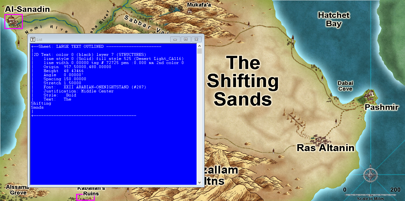
As you can see, it correctly identifies it even if it is displayed using Arial.
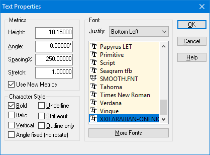
There is also another way to see what fonts are defined in a map though, just hit :CC2TSPEC:, the dialog shows all the font referenced from the map. You can't see what font is used for what text from here, and it shows all the fonts defined in the map, which doesn't mean you have actually used them, but it should be enough to help.
-
Export to different styles from FT3 to CC3+?
FT3+ can't use the CC3+ maps/templates directly. The way the FT3 exports creates the correct fill for the landmass is by relying on a texture overblend effect on the landmass (and whatever else), it doesn't set the entities up with fills like when you normally draw the map. So when you add a new template to it, you also need to go in and add that texture overblend effect to the appropriate sheet (and point it to the appropriate bitmap fill file). Look at the LAND sheet in the existing templates there.
-
Trace not selecting entity
The trace always goes through the point on the entity you used to select it. If it goeas around all the coast except for the section you want, it is an indication that you didn't select the entity to be traced using a place inside that area.

-
Deleting / Erasing along a line?
You can use the SYMDELNEAR command to do this.


