Monsen
Monsen
About
- Username
- Monsen
- Joined
- Visits
- 723
- Last Active
- Roles
- Administrator
- Points
- 9,011
- Birthday
- May 14, 1976
- Location
- Bergen, Norway
- Website
- https://atlas.monsen.cc
- Real Name
- Remy Monsen
- Rank
- Cartographer
- Badges
- 27
-
Project Spectrum - Part 2
-
Raised Floors
Drawing tools select the sheet automatically to help you place things on the right sheet.
In this case, the easiest here is to just use Change Properties on it after drawing to just move it. Or, you can use the basic tools in the right hand menu instead, these don't have any smart functionality. Just manually set the fill style, and then use the Box or Polygon tool.
-
Raised Floors
-
Global Map takes you from present to 750 million years ago
Woo.. This is a very nice resource. Great when trying to map ancient earth, as well as give an indication for how one can modify once own game world to generate historical maps.
Maybe someone will do this for Nibirum :)
-
Spectrum - the mesa poll
-
Mike Patterson (Maidhc O Casain)
When you say interesting, I think what makes the people around you interesting is that we are all so different. This is a rather diverse group, joined together by one common interest. Which is also why it is so fun learning who all the people around you are.
That wake surfing looks seriously fun, wish I lived somewhere with a bit warmer waters.
I hope that trip to Peru works out as planned. I haven't been there myself, a bit to far, but it is a very interesting region. I am sure you will have a great time. You should keep us updated.
-
Jim Abbott aka Damon Jynx or Rikki Grosevale
-
Kevin Morris aka Gothic03
-
Community Atlas - Themisia - Myktolos
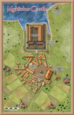
Myktolos castle have now been added to added to the atlas. Thanks for the contribution. Myktolos Castle
 -
Quayuazue aka Darren McDowell


