


Monsen
Monsen
About
- Username
- Monsen
- Joined
- Visits
- 723
- Last Active
- Roles
- Administrator
- Points
- 9,029
- Birthday
- May 14, 1976
- Location
- Bergen, Norway
- Website
- https://atlas.monsen.cc
- Real Name
- Remy Monsen
- Rank
- Cartographer
- Badges
- 27
Latest Images


-
Problem with starting CC3+
Looks like CC3+ isn't finding your data directory for some reason. There should be a file called @.ini in your installation directory (c:\program files (x86)\ProFantasy\CC3Plus) that contain the path to your data directory. Check that this is correct.

-
Looking for a rising sea level map
Tools -> Global Raise -> Water Level will rise the water level by the specified amount. Works fine on the mola2x2a Mars data if that is what you are using.

-
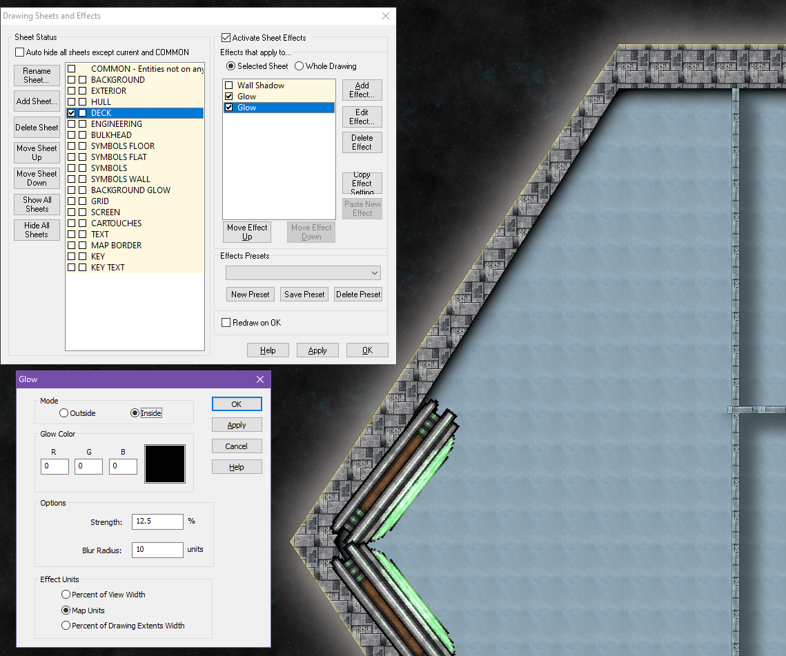
deck isn't showing shadow with hull
The reason for this is that the hull is a massive polygon below the deck polygon, so there isn't really and edge here that can cast shadow as far as the hull is concerned. And the deck itself is set up to cast a shadow, but shadows extends outwards from the caster, not into it, you can see you have a shadow from the deck in the lower right of the map.
What I would have done here is to use a black glow (set to inside) on the Deck sheet, and disabled the wall shadow on it.

-
The Sunken Temple
@Quenten wrote:
So different from the cardboard DM shields, everyone sitting round a big table, with handwritten character sheets, miniatures on the table with a homemade hex grid board, drinking plenty of soft drinks or coffee, and eating junk food like it was going out of style - oh, and the arguments about rules, and the squabbles between married couples, and the 'bonding' between two would-be lovers.
Well, things are not that much different. Yes, the miniatures and grid have been switched out by a VTT, and handwritten notes are now done digitally, but we still sit around the table, argue about the rules, and consume tons of snacks. And with a VTT you don't have to have the minis for everything. And it saves lots of space on the table.
If the DM was cruel (the default position), he would call out directions of the corridors and rooms, with some dimensions-and we had to draw the map ourselves. If the DM was particularly pleased with themselves - for reasons having nothing to do with DND, they would draw the map on paper as we went.
I used to be the DM that described the place and had them draw their own maps, but I realized that it took away a lot of the game. Players would spend unnecessary much time drawing, and they would frequently ask me to repeat distances (which I could hardly refuse to do, the characters were there in the middle of the dungeon and could re-check things as often as they liked).
This is why I love the VTT and projector approach. My players only see what their characters see in that moment. It saves me from describing every minute details about direction and distance, but the players see the current situation. I don't let them see back to where they have been, only the exact place they see right now. If they want a map, they can draw it, but I save a lot in explanation, and it looks so much prettier. And I can put in semi-surprises as part of the map drawing. Now, they need to actually use their eyes to spot certain things instead of me describing everything.

![[Deleted User]](https://secure.gravatar.com/avatar/c75d9a245b74d9c59be0999ea81ca541/?default=https%3A%2F%2Fvanillicon.com%2F92add7f8c954488718110edc4896ad39_200.png&rating=g&size=200)
-
First Map
Looking good. Glad you found a safer area, or those Umber Hulks would have taken good advantage of those collapsed wall segments.

-
WIP: Fane of the Swamp People...
Now, why would you remove the secret grass?

-
Assigning drawing tools/fill styles to custom menu buttons. Is this possible?
You should be able to assign the command
DRAWTOOLSM drawtool name;to a menu button.
Likewise
FSTYLE fill style name;should set the current fill style.
See this article about menu editing for doing the actual menu changes.
Do note that menus aren't style sensitive, so the buttons would only work properly as long as the current style actually have a tool/fill by that name
-
How do I draw a curved road?
To get curved roads, right click the road button and select one of the Smooth tools.
As for freehand drawing, that is something rarely used in CC3 maps, but if you wish to draw a freehand road, simply use extract properties (dropper button on the left) on an existing road to set the current drawing options to match the road, then use freehand scetch (pencil icon on the right) to draw a freehand line (click once to start and once to stop, do not hold the mouse button down while drawing). -
City of Nyxotos for the Community Atlas
You.
Remember, you can search for text in maps using either the atlas online search, or by the search in CC3+ itself using the atlas index.
-
Where can I find great resources for the creation of a subterranean world?
Maybe the Dungeon Worlds annual can be a good start?
Won't help you build crystal cities (not sure about resources for that), but it is a nice way of mapping an Underdark-like world.

