


Monsen
Monsen
About
- Username
- Monsen
- Joined
- Visits
- 724
- Last Active
- Roles
- Administrator
- Points
- 9,029
- Birthday
- May 14, 1976
- Location
- Bergen, Norway
- Website
- https://atlas.monsen.cc
- Real Name
- Remy Monsen
- Rank
- Cartographer
- Badges
- 27
Latest Images


-
WIP - Senan
Good luck with the surgery.
Related to the problem using the mouse in general, remember that quite a lot of CC3+ can actually be done using the keyboard. This allows you to even work one handed. Some things do get quite a bit more cumbersome, but it do allow one to keep working.

-
Community Atlas: Map for the Duin Elisyr area, Doriant
The atlas is at https://atlas.monsen.cc
Generally, the amount of reserved areas compared to the number of maps is quite low, so finding one is actually difficult, but if there are any reserved areas on the current map, there will be a button below it named "Show reserved areas". That that button does is just to enable reserved ares to show up with a hotspot just as the existing areas, meaning every hotspot marked on the map leads to either an existing map, or a place someone has reserved, while a non-marked area of the map is open for the taking.


-
Live Mapping - Hiding in the forest.
Yea, aligned fills makes it much more friendly for rotation. I didn't have the time to cover that in the stream, but it is worth doing if you plan to copy and paste it rotated like this.
-
isometric throne symbols
Do you have the CA66 Isometric Dungeons issue? There is a furniture symbol catalog in that one (
@Symbols\Dungeons\Annual Isometric Dungeons\CA66 Furniture.FSC) that has a proper 4-way throne that should fit.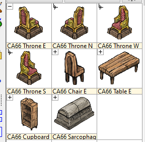
-
Community Atlas - Irisian City States - Dimitrios island
Yea, you can put a lot of things on small islands. I've been to a couple of the Caribbean ones. Barbados for example is 169 square miles, which looks about similar to yours in size, and has a population of 300 000 and lots of interesting locations.

-
Poly fill doesn't show up in the Bitmap tab when using Extract Properties
Yea, Ralf only shows some simple editing there, but it gives a good overview of the process needed to manipulate hatch styles. But you can do any operation you want when editing them, including scaling them using the :CC2SCALE: command.
But yea, bitmaps are much easier to deal with.

-
Community Atlas - Irisian City States - Menina Island
Menina Island can now be found in the atlas. Thanks.
-
Lost a symbol . . . by messing around :(
Deleting them from the map still shouldn't affect the symbol catalog though. After opening the problematic map, did you try and change symbol catalogs to something else, and then back to the vegetation catalog, using the symbol catalog button in the top toolbars?
As for copying thing to a new map, that is easy. You can either copy everything to the clipboard (Edit -> Copy) [Just keep an eye on the prompt to make sure you complete the command properly] and then paste it into another map, or you can use Draw --> Insert File to insert the old map into a new one.

-
Username Change
How do you log into the forum? If you use the google social logins it will automatically grab the name from the google profile, there is no option to change that.
If you wish to use another username, you must log in using the forum's own username/password login.

-
[WIP] Community Atlas - Rhaghiant (western Doriant)
When it comes to symbol sizes, I think an important part of a map is that information is legible when zoomed out. Exactly how large that is depends on the map obviously, but in most cases, it will mean the symbols will be covering more area than the settlement actually takes up.
Currently, the settlement symbols do look a bit small IMHO. They don't have to be scale 1, but I think they could probably be 0.5.
More "precision" is usually better done by making a new local map from parts of the main map, which can show more details, and "more correct" settlement scaling. Exactly where the cutoff point for detail level lies between those maps of course differ based on the map itself.

