


Joel M
Joel M
About
- Username
- Joel M
- Joined
- Visits
- 5
- Last Active
- Roles
- Member
- Points
- 31
- Website
- tegwynsaga.com
- Rank
- Newcomer
- Badges
- 0
Latest Images
Reactions
-
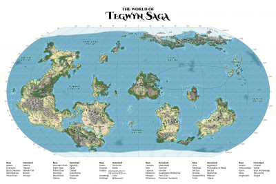
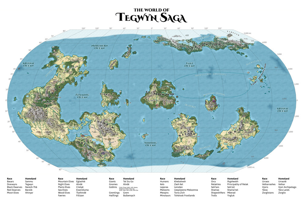
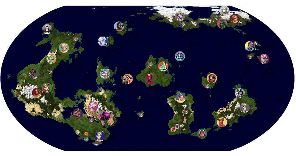
Tegwyn Saga World Map
I finished my RPG's world map! (For now.)
Last month, I posted some Fractal Terrain stuff for it:
Now, I've taken the export and made a CC3 map in the Mike Schley Overland style. The next and numbers around the map were added afterwards in Photoshop.
I finished it up yesterday and added it to Tegwyn Saga's downloads on DTRPG. Hope the players enjoy it! I might work with my artist to add a nice border, then set it up for a print poster at some point, but for now I've just done a 4k render for download.
Gallery for 1920x version:


![[Deleted User]](https://secure.gravatar.com/avatar/c75d9a245b74d9c59be0999ea81ca541/?default=https%3A%2F%2Fvanillicon.com%2F92add7f8c954488718110edc4896ad39_200.png&rating=g&size=200)


 and 1 other.
 -
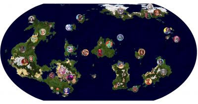
Tegwyn Saga planet (FT3+) and people
I made a tabletop RPG called Tegwyn Saga, and some of the race descriptions reference geography, but I didn't make a map for it. I had an old one from PlanetGen, with country names added in PS, but enough changed, and I lost the PlanetGen seed, that I wanted to do a new one. Having picked up FT3+ and CC3+ in bundles, I'm finally on my way!
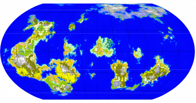
In Fractal Terrains, I generated a planet, then did some research, (re)watched some Artifexian videos, figured out basic currents and wind directions, and proceeded to spend a lot of time in FT3 futzing with rainfall. Also made some temperature adjustments, slightly narrowed a couple mountain ranges, and placed a handful of new mountains where I needed them so I could avoid contradicting the already-published book!
The hand-placed mountains don't look as good as the generated ones, but the end destination is going to be a CC3 map anyway. I'm planning to export to CC3, then redraw stuff (probably in Schley style) to look more thematic. Probably the most unrealistic part is that many of the mountains generated in very large clusters rather than long ranges, which is unusual on Earth, and I didn't really mess with them much.
Here's a render with Terraformer color (true color 19) and image climate (131), with tokens for all the playable races added on top. Giants (ironically) and Dwarves are smaller because there are multiple subgroups next to each other. Goblins are smaller because they're smaller groups scattered everywhere.
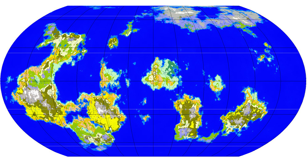
...and here's a climate render!
Gallery with larger images:

-
Quo Vadis Monthly Symbols?
I think the monthly symbols have been great! I'm using the Mike Schley Overland style for my big world map because it has a lot of variety, so the monthly freebies being for that style has been perfect.
I'll echo a couple other comments and say some city and fortress symbols for other cultures would be good. Specifically, I needed a Japanese-style castle and had to borrow one from a different style, which only kind of fit.
-
Fractal Terrains 3 v3.0.20 - Issue - Find Rivers
Apologies if it's bad form to necro a post like this, but I might have found a workaround for a similar issue in FT 3.5.1. The workaround is only useful if you haven't done much manual offset editing. I'm commenting in case users like me have this problem in the future.
My symptoms were a bit different, but I think they had the same cause: somehow, I ended up with a smallish area with preposterous depth (way over -40k, iirc) near 180 longitude. I think something in the basin-filling, land-expanding, or incise flow tool went ballistic. When I tried to find rivers, it wouldn't show anything unless I slid the slider way over to the long end, and then the rivers showed as big wads over random spots in the ocean. (I think the spots even stayed the same in screen space if I rotate the world and try again, but I could be remembering wrong.)
Workaround: I worked around it using clues from jslayton's post above. Tools > Global Set > Land Offset Edit > 0, which unfortunately erases manual offset edits and actions like fill basins and expand land. This switched the bazillion-deep spot near 180 longitude to a quite high spot, and rivers started working again. I edited the spot with pre-scale offset to get it down to a reasonable depth.