


Loopysue
Loopysue
About
- Username
- Loopysue
- Joined
- Visits
- 9,967
- Last Active
- Roles
- Member, ProFantasy
- Points
- 9,852
- Birthday
- June 29, 1966
- Location
- Dorset, England, UK
- Real Name
- Sue Daniel (aka 'Mouse')
- Rank
- Cartographer
- Badges
- 27
Latest Images


-
Is outer glow the best way to darken symbols?
Hi Julian :)
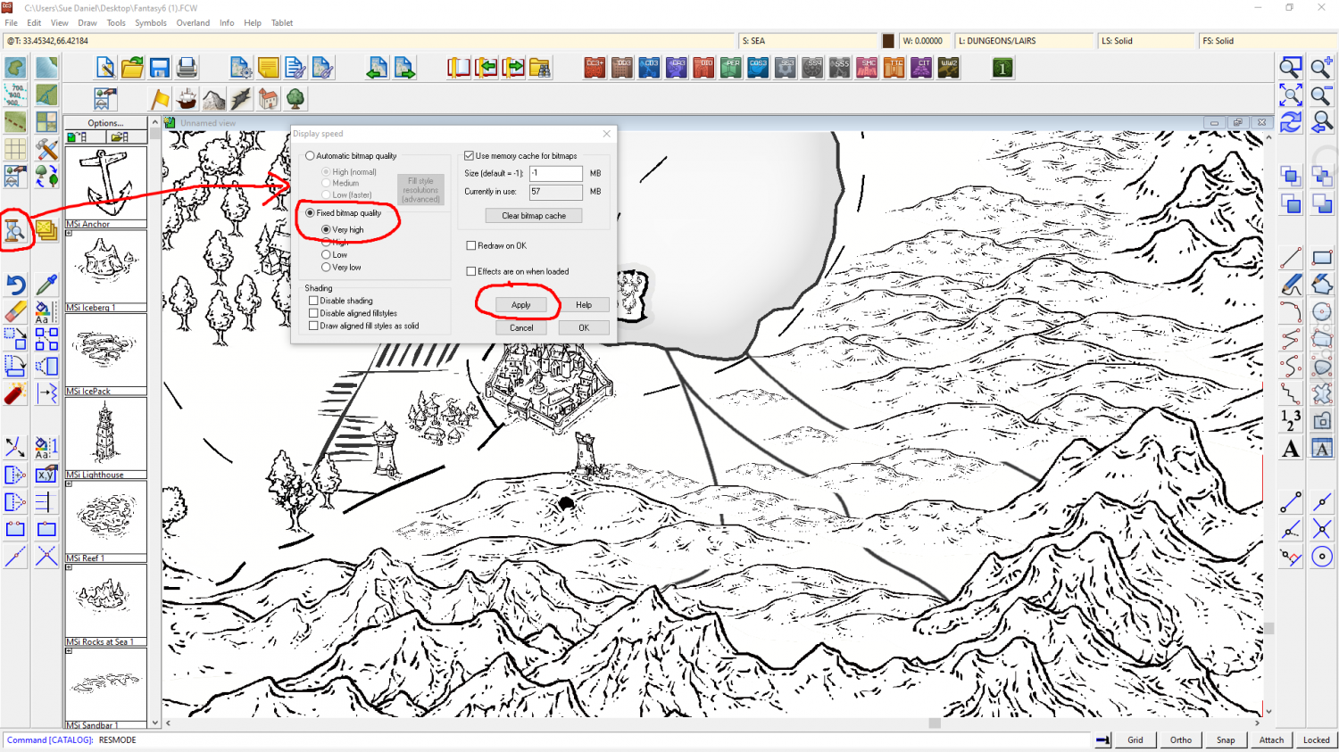
It might be that you are seeing the mountains at a slightly lower resolution, which will slightly blur the sharp lines into the white area around them. Try opening the Display Speed dialog and picking Fixed Bitmap Quality to set it to Very High, and then Apply the change. This should give you sharper and hopefully blacker mountains.
I hope you don't mind, but I have demonstrated this here using a view from the FCW file you uploaded on your other thread, as I didn't have an example of my own in that style to hand.

-
Inn/Tavern battlemap (WIP)
That's a really good map elezriata - and "Hi" from Sue Daniel ;)
Have you heard about the Vintyri Collections? These are huge collections of free third party art assets that might help with things like more variation of rugs and furniture.
The links for all the assets can be found here:
Where the Vintyri collections in particular are concerned please read the installation instructions really carefully.


-
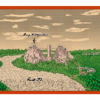
[WIP] DOTR The End of Castle Wittgenstein
Wall tool:
The wall tool is a line drawing tool and doesn't join into a closed polygon. A wall is a line with a width. Conversely, the room drawing tool automatically draws a closed polygon wall (which is rendered hollow by the line width) because it doesn't know where you want the door to be, or even if you want a door.
The bridge symbols meet at the highest resolution. There are 4 images of each symbol in a graded set of resolutions to speed up the zooming process, and where they are fuzzy-edged pixel images sitting on a precision vector reference grid they can appear to have gaps between them at lower resolutions. If you have issues with this it may be necessary to draw another line of them off the map somewhere initially using the snap grid so they are perfectly horizontal or vertical, and jink them closer together by hand. Then the string of bridge bits can either be grouped and moved, or just moved to position on the map.
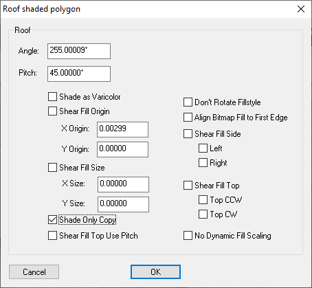
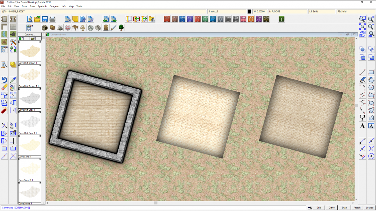
1) Textures aren't aligned unless they are made to align, and you can only do that with a filled polygon, not a wall. Happily, your floor is a filled polygon. Hide all sheets but the floors and right click the Polygon button on the right toolbar. Click the floor on one of its long sides. The fill will align to that side, but it will also shade like a pitched roof. To get rid of this you need to type EDITSHADING on your keyboard and hit the Enter key. This is a command you have just given CC3. Check the command line at the bottom of the window and see that you are being asked for the entity to be edited. Pick the floor and then in the dialog that appears check the little box called "Shade Only Copy" and OK.
You should end up with something like this. Here I have shown the 2 steps from left to right.
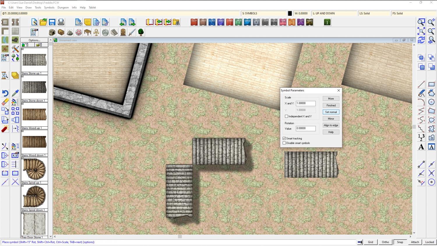
2) Before you place the symbols, but while you have them on the crosshairs ready to paste, right click your mouse and then click the Set normal button and the More button and see if that works better for scale. The stairs align perfectly with the snap grid for me.
3) The interior wall is a symbol, not a fill. I rarely use them at all because they don't match the fills that well. I usually use thinner regular walls drawn with the wall drawing tools, or I draw the entire building in these interior walls.
I think I got everything there?
-
1876 Centennial Campaign Map
It looks good :)
Hachures are something that can't be drawn automatically in any app. Well, not true hachures anyway. Most hachures are not done properly when they appear, but are only used as rough indicators of slope.
When I was at college many years ago, one of the 'units' I did as my course was The History of Cartography. It was pretty dry and surprisingly uninteresting for the most part because we didn't look at any actual history or even individual cartographers and maps. I didn't even know about the Ferraris Map until quite recently. Instead it was all technical 'how this was done', 'how that was done'. Hachures I remember well. Their length, width and density all depend on length and steepness of slope. I'm not even sure I could do a hachured map, even though I know the precise theory and have the ability to draw. It is a seriously skilled piece of work to do a single slope, never mind a whole landscape. Hat's off to those Swiss cartographers who made them so famous!
So don't feel bad about not doing hachures. Never feel bad about that. Doing hachures the right way is like painting the Mona Lisa. Dead difficult, and there are a thousand easier ways of doing it that look just as attractive in their own way.

-
Suggestions for a Map and Vintyri
It would be worth checking with copyright owners where possible, for some 'free' things are not as free as they give the impression they are. Most are free to use, but not necessarily commercially as (for example) VTT tokens for redistribution.
I'm not trying to put a damper on your project. Only concerned that you shouldn't accidentally fall foul of people who can turn out to be unexpectedly nasty. I've had experience of that kind of thing. A completely innocent mistake on my part was loudly and very publicly declared to be blatant theft and I was compared with a very real and rather infamous map thief! Fortunately for me the accusation was transparently a laughable exaggeration, but others have not been as fortunate.
My accusers have continued to make my life pretty uncomfortable on other forums ever since, so please don't do this to yourself - not by mistake at any rate. I've been persecuted for so long that sometimes I almost wish it HAD been deliberate, because then at least I would deserve it.

