


Wyvern
Wyvern
About
- Username
- Wyvern
- Joined
- Visits
- 3,237
- Last Active
- Roles
- Member
- Points
- 5,515
- Rank
- Cartographer
- Badges
- 24
Latest Images


-
Maps of Anglo-Saxon England
When hunting for maps today to assist a colleague on an ancient history forum, I happened upon this page on Kemble: The Anglo-Saxon Charters Website, which has links to a host of beautiful, sometimes annotated, hand-drawn, black-and white maps of Anglo-Saxon England, all done by the cartographer Reginald Pigott for various books in the early 21st century. They're especially valuable, as some show the established, or best-estimated, extents of features like forests, marshlands, and coastlines, many of which have altered since the 7th to 11th centuries CE. They're free to download for personal use, and are well worth a look.


-
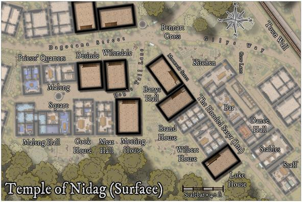
Community Atlas: Temple of Nidag, Stormwatch, Emerald Crown Forest, Alarius
Thanks Sue! Of course, it's my own fault for making the mapping this complex in the first place, but that doesn't help at the time!
And it's another lovely mapping style, not entirely dissimilar to Ralf's current Hand-drawn Dungeons one, expanded by the new Annual issue, as shown-off in yesterday's livestream. Indeed, I think if that latter style had been available back when I was wondering which to use here, I might have gone with that instead. Now I can try it another time though 😊.
-
Community Atlas: Temple of Nidag, Stormwatch, Emerald Crown Forest, Alarius
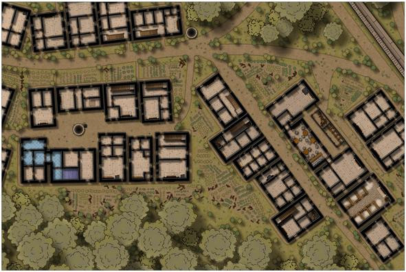
With the main surface part completed, it was time to ascend in the properties with rising stairs. A new sheet was added appropriately in the stack to allow the addition of a "haze" blanket, to mist-down the lower level buildings and features. This was achieved very simply by adding a map-sized rectangle of the "Solid White 40" bitmap onto said new sheet.
After that, copies of the full wall lines (from the initial line-tracing, shown back in the second and third posts above, from the 2nd and 5th of November), the floors, and staircases were placed on three more new "Upper Storey" sheets, to give this result:
This illustrates too that higher features, such as the main trees and battlements of the Town Wall, were also set above the "mist" panel. The stairs look very flat at this stage, as they're essentially simply markers for where the stairwells will go.
The next step involved cutting holes to show parts of the existing stairs rising to their landings on this upper level. Of course, the holes had to be cut through not just the new upper-level floors, but that mist panel as well. "Color Key" effects on both sheets provided the mechanism, although to prevent any mishandling, colour 6 (magenta) was used only on the upper floors sheet; colour 4 (yellow) was used on the mist panel sheet:
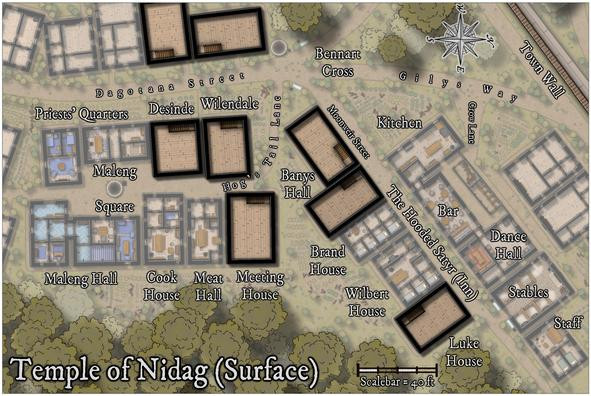
Further refinements would be needed to make these stairwells look a bit more real (including adding shadow lines and an upper banister rail), which became practical only after the new upper interior walls were in place.
One complication was that because I wanted the final Atlas map to have a toggle to hide or show this new upper level, everything had to be added only onto a new "Upper Storey" layer. That created a few issues later.
Next though was a much simpler step - adding all the new upper storey fireplaces:
They're in the same places as those on the lower level, although some were moved a little subsequently to better fit their new locations.
Then the walls, windows and doors started to be added. This initially took a degree of organising, because to have things like doors and windows cut the wall lines, the walls MUST be on the "WALLS" layer. The wall-cutting tools and symbols don't function otherwise. Only they also have to be on the Upper Storeys layer to work in the final map! So this led to a lot of hiding and showing various sheets and layers at different stages of the process, which all needed to be done in order.
And (of course!) there was a further difficulty, because with identical wall colours and effects for both the upper and lower storeys, wherever the two levels of walling stacked, there were clashes of transparency acne oddities along some of the upper storey walls. So that meant adding yet another sheet, onto which the final cut new wall lines could be copied, with no effects, and their colouring changed, to stop that. Much of this was worked-out using the two west-side buildings, and a heavy use of the "Undo" function:
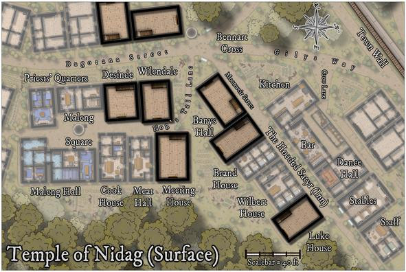
The process eventually stabilised per building as:
- Draw new internal walls
- Add door and window symbols inside (not on) the new wall lines
- Hide everything but the upper storey walls, window and door symbols
- Change the wall lines to be on the WALLS layer and unhide it
- Hide the lower walls (because they're also on the now-visible WALLS layer, so can be cut again too)
- Add new windows and doors to cut the new upper wall lines; then delete the previous door and window symbol markers
- Change the wall lines back to the Upper Storeys layer
- Copy the wall lines to the Walls Upper Mask sheet
- Change the colour of the wall lines on said Walls Upper Mask sheet
- Unhide all sheets and layers to check everything works, then turn off the Upper Storeys layer to ensure nothing's been missed that should be on it
One more, variable, interjection of an additional number-point anywhere in this list was:
- Scream in frustration (other options are available...) when something's been done wrongly, stop and redo said problem, possibly more than once.
Eventually, however, this was the result:
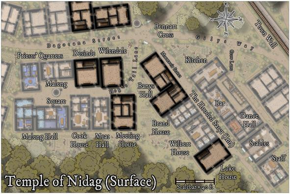
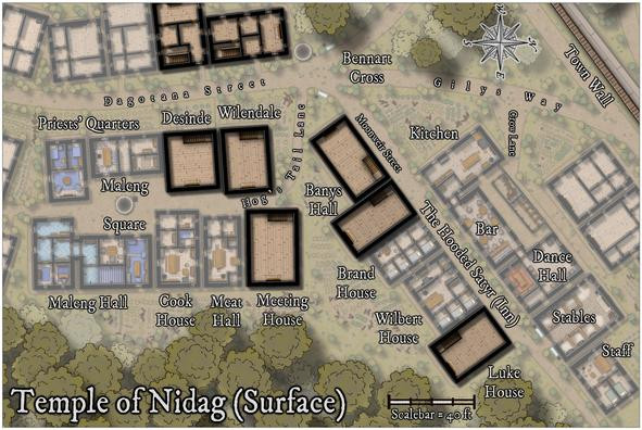
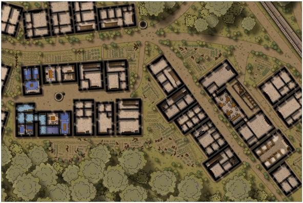
As envisaged, most of the upper storeys were to be dormitory-style communal rooms for cult followers, hence the large open spaces, albeit there is also the practical consideration if these were genuine buildings, to help reduce the weight the lower storey needs to support. The first buildings to be furnished show what this meant:
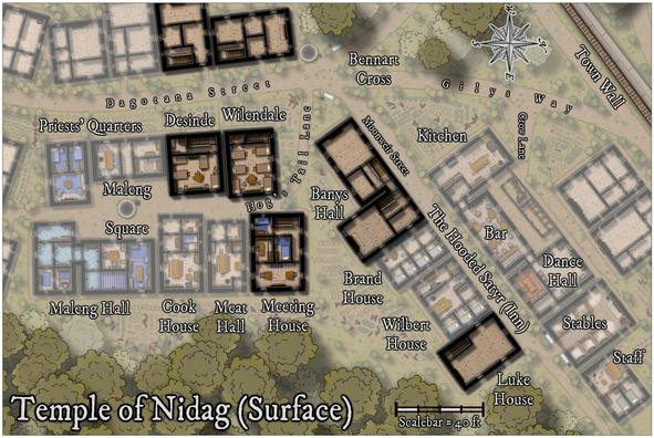
Meeting House is a bit different, with a library and a couple of somewhat higher-ranked cult leaders in separate rooms. As before, the structures not directly connected with the cult on the western map edge, are to be left unfurnished. The remaining three properties were not to be so left alone though, and this is the higher-res final version of this map:
While not mentioned sooner, this view is now hopefully clear enough that the hinted-at connection between the two parts of Banys Hall, is obvious. I'd been intending this ever since deciding to place the two stairwells on the lower floor as they were.
Next time, the delve underground begins!

-
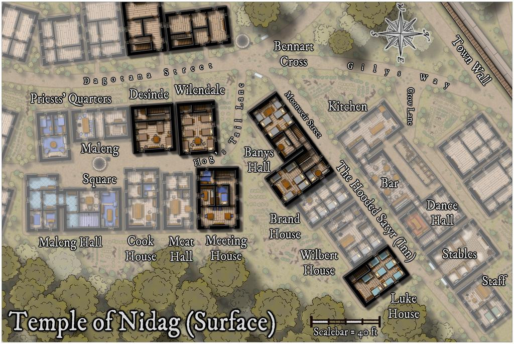
Community Atlas: Temple of Nidag, Stormwatch, Emerald Crown Forest, Alarius
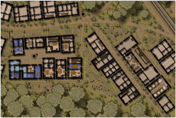
First task on resuming mapping was to complete the structural building interiors and gardens:
However, while I was "digging" the gardens, it became clear the vague not-path from the road to the back of the inn wasn't clear enough. At first, I tried adding patches to cover the hard-line road edges, and tweaking the effects that created those lines too, but it didn't improve, so ultimately, I redrew the connecting area as a full stretch of the road-style dirt pathway, while retaining its funnel-like appearance as seen from above. Doing this though also made me think further about these roadways, so I also added some more of those little "weed clumps" along all the roads, notably at the junctions, in the places where wheels, hoofs and feet would be less likely to pass frequently, all to make the roads look a bit less maintained. They are beyond the main settlement's boundary wall, after all.
Plus we can see how that mid-property fireplace worked out in the end - a fireplace on one side, a cooking range in the narrow, galley-like kitchen on the other.
With this completed, it was time to begin detailing the internal contents of the central properties, those belonging to the temple and its ancillary elements. Temple access hall and priests' quarters first:
Followed by the dwellings of the lesser clergy and higher-ranked followers:
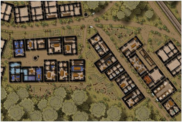
After which came the rest of the inn:

There were a few other changes made here as well. I wanted some water troughs for the stable block, which were simply drawn using fill polygons, as there aren't any suitable symbols in this style (although I did repurpose some stretched versions of the unlit braziers for the wall-mounted hay baskets in the separate stalls - likely too small to see at this res). It then occurred to me that other troughs could be positioned elsewhere, so I put a couple more in by the main crossroads, not far from the well there, and added a few cauldrons resized as buckets nearby, as already done elsewhere.
In addition, I changed the sheets for some of the larger furnishings, to give them a bit more shadow, and thus presence, when viewing the whole map, as I discovered I'd already done that for the bar furniture at the inn earlier. Not sure now if that was by accident or design though!
Finally, the last row of properties could have their interiors completed:
I did think of furnishing all the buildings, but felt that would draw attention too much away from the more central properties linked to the subterranean map. This does also leave open the possibility to install player-characters in one or other of these should they wish to spy on the temple and its congregation at some point. Plus it was common practice in many of the earliest D&D maps to show no roofs, just walls, stairs, doorways and windows, for surface buildings.
That just left the labelling, for which I chose the default font that comes with the Naomi Van Doren mapping style, the awkwardly-named IM FELL DW Pica PRO. Names for most of the items were predetermined using tables in Mythmere Games' "Nomicon", as noted in the first post above here, and allocated where appropriate. Thus we reach this completed first map, or at least its surface view, now at full Forum res, no less:
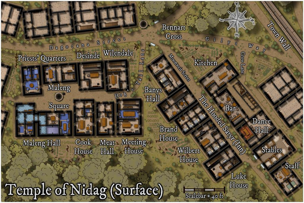
I'll spare you details of how much effort went into tweaking the effects, sizing, colouring and placement of the labels, compass rose and scalebar; suffice to say, it was almost a session in itself.
Next will be designing the upper floors of the properties here that have stairs, which may explain how that Banys Hall label applies to what are apparently two separate buildings at present...


-
Live Mapping: Random City
Thinking further about this option since the livestream, it's a powerful tool no matter what kind of settlement you're wanting to map, even if it's to fit in a pre-drawn setting, as anything unwanted the random option generates can be readily moved or removed to fit terrain features (e.g. coastlines, rivers, cliffs).
Different areas of a larger city could be created randomly in different ways (medieval and modern could be mixed, drawn from different random maps, for instance), and then fitted together in a suitable CC3+ master file, simply by copying over the relevant parts of the separate randomly-created settlements.
Naturally, this would need quite a degree of restructuring and amending after the fact to make everything fit together correctly, although a lot of the base work would be done from the random creations.
It would also be possible to "super-detail" parts of a settlement drawn in a quite different style, such as a Watabou-type settlement, leaving the "blank" areas for segments that weren't necessary for such detailing. Again, unwanted parts of the random design would need removing, but this would be something to consider if of interest.
