


Wyvern
Wyvern
About
- Username
- Wyvern
- Joined
- Visits
- 3,238
- Last Active
- Roles
- Member
- Points
- 5,517
- Rank
- Cartographer
- Badges
- 24
Latest Images


-
Sticky Note Dungeon
And now the Sticky Dungeon has been released into the wild, as the October 2024 Cartographer's Annual issue!
Many congratulations to C.C. for this fantastic achievement!


-
Community Atlas: Barrows of the Ferine Magi area, Feralwood Forest, Alarius
So finally, an actual map I DID make here!
The area map was going to be drawn and filled first. While the basic format for the style of hex-map was already established, I had some new sets of random design mechanics I wanted to try, to determine what was going to be in those identified hexes. These would later have Shadowdark notes added into the map's PDF file, where relevant, to keep a degree of consistency with the other maps in this current collection.
So the contents for each labelled hex were determined using, or adapted from, tables and random processes in "Into the Wild - Omnibus Edition" (from Third Kingdom Games, 2023). This is designed to work with the Old-School Essentials RPG by Necrotic Gnome, so it draws on creatures from that, and other associated sources among the established "old-school-rules" form of the RPG hobby (as to an extent does Shadowdark). This was my first time using Into the Wild, and it proved something of a challenge, as its layout is not the clearest to find things quickly, or avoid accidentally missing some key element. It did though come up with a lot of interesting ideas, sometimes after a little tweaking, and with occasional additions from the random Shadowdark tables.
The nature of the area, having wildly magical, magic-free and normal magic regions, meant I was looking primarily for unusual creatures or aspects for whatever came up randomly, and so often chose tables accordingly. I also opted to check for both features and creatures in each highlighted hex, again with adaptations, so not everywhere ended up with both elements. One aspect I decided against was involving any high-tech aspects from the barrows also appearing on the surface, as I quite liked the idea that only if a party of adventurers opened one of the barrow entrances and failed to close it properly, might those denizens begin creeping out into the world.
As noted for previous of my area maps, once the features list is decided, other aspects of the map start to fall into place, here including where the streams might lie, as well as larger areas of new terrain types, including some odd, black-sand dunes, and low hills, notably towards the eastern side of the magic-free and wild magic regions. After which it was time to progress to the CC3+ mapping:
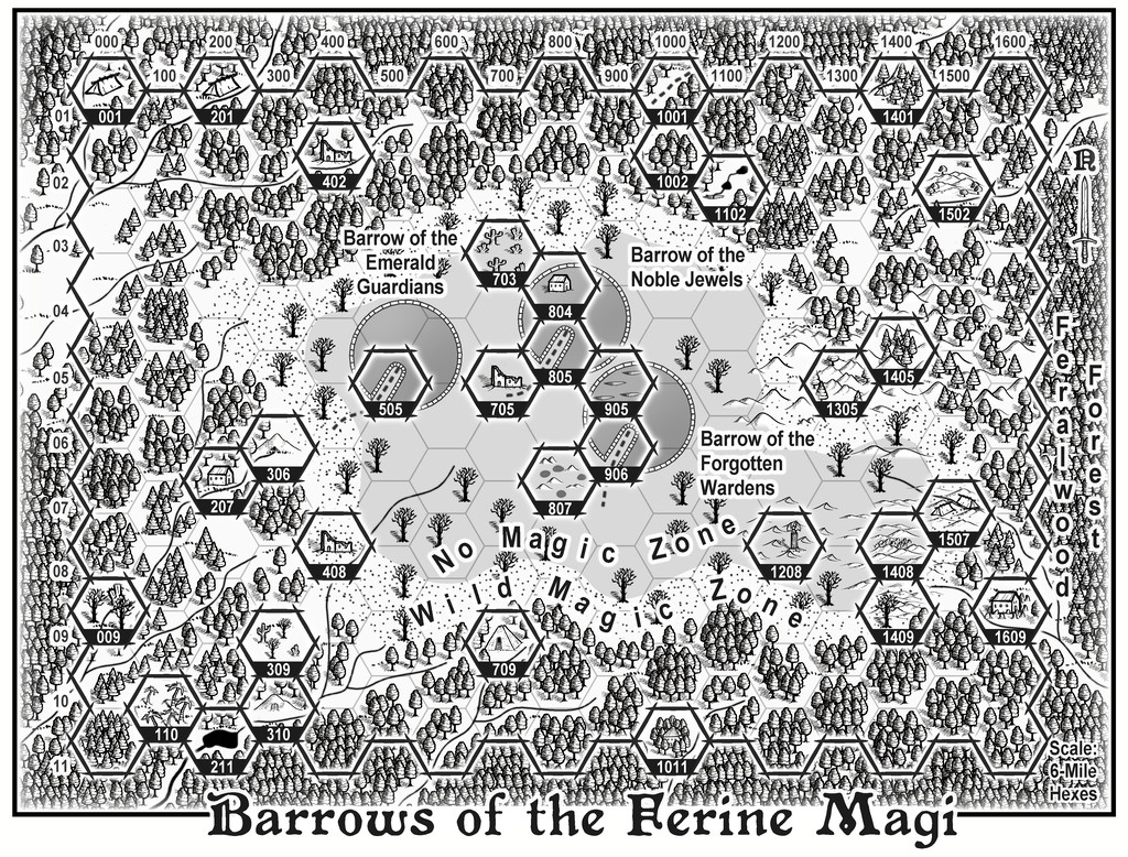
This too proved quite a challenge, since the forest density originally hid too much of the normal hex lines (those not highlighted) and had to be revised a couple of times, to try to keep things clear enough while not looking too hex-based. Similarly, ensuring the highlighted-hex symbols weren't overwhelmed by the trees involved more tinkering. The No Magic Zone was possibly the easiest, as it was just the background colour revealed by punching a Color Key hole though the overlying terrain fills, creating the Wild Magic Zone's circuit simultaneously - that circuit achieved by a desert (dot-shaded) terrain fill polygon, without any effects to ensure the edges were sufficiently obvious.
A few extra symbol-shapes had to be hand drawn, such as the little pools (of mercury) in Hex 807, and the depressions in Hex 905 (harpy dust baths), one more of which items was resized and reused as the sinkhole for the stream in Hex 1102. Most other highlighted hex features were either normal symbols, or resized ones (sometimes resized differently in one or both dimensions).
The main drawn items were the three gigantic barrows, which were so large, they needed preparing as specific items. From the start, I thought they'd be more interesting as definite circles, as that seemed weirder than making them less neat and regular, aside from, of course, being easier to draw! Ultimately, I simply drew the first one, then copied it to the other two locations. Initially, I created a new drawing tool to prepare the outer circuit as white with a dark grey outline. However, that proved problematic at the join where the avenue leading in to the centre of the barrow was, with the darker outline showing a break there. Thus that idea was scrapped, and the outer circuit drawn instead using a dark and a white line of different widths on separate sheets. The little cross-lines, helping to suggest the outer stone walling (I've pretty much envisaged these as gigantic versions of the great Newgrange barrow in Ireland), were simply hand-drawn, and are deliberately not all straight or evenly-spaced, to hint at something maybe less manufactured about these structures, despite their overall regular forms. The interior dome was drawn using a Solid White 10 fill circle, or more accurately, copied and amended to be so from one of the outer circuit lines, onto a new Barrows sheet. This had a suitable lighted bevel effect added, tweaked to help darken the domes to make them stand out better. For some reason, the Solid White fill worked better than the Solid one in doing so.
Labelling the map wasn't altogether straightforward either, trying not to hide too many of the dead tree symbols, and avoiding the highlighted hexes, while still making clear what was being labelled. The "Scale" note was the most trying (bottom right corner), as having just squeezed in a "Feralwood Forest" label on that side of the map, I couldn't decide if I should lose the eleventh hex in column 1600 to keep the scaling comment on two lines, or lengthen it to three. In the end, the latter won out, as the map felt lopsided because of that missing end-hex. Well, I kept noticing it, at least!
Onward now to the subterranea!
[EDIT 19 November 2024: Although I originally added the provisional PDF description for the map to this post, I've removed it now, as the final version has been submitted for the Atlas!]


-
Community Atlas: Barrows of the Ferine Magi area, Feralwood Forest, Alarius
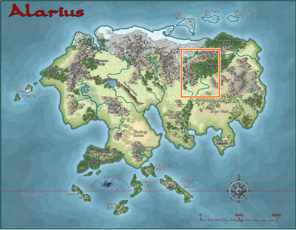
Back for another visit to Alarius for the next segment in my sort-of Dungeon24 mapping (now so delayed, it's increasingly likely to become "Dungeon25" soon...). I noted in the topic for my immediately prior maps, set in the Whispering Wastes of Haddmark, Peredur, that this was scheduled for somewhere in the Feralwood Forest region of northeastern Alarius:
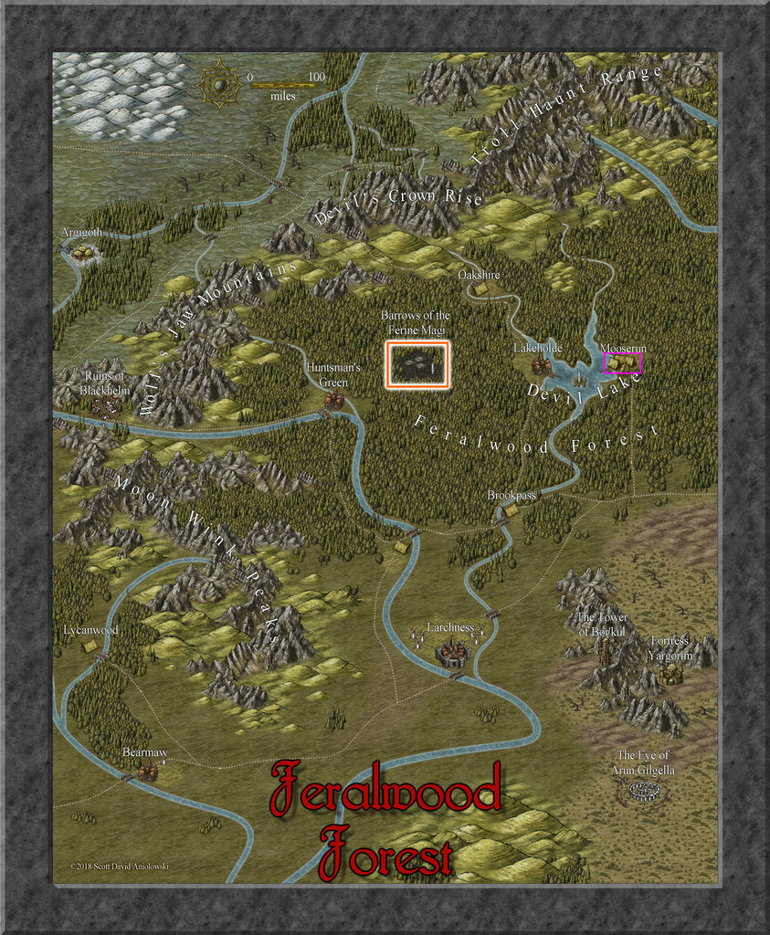
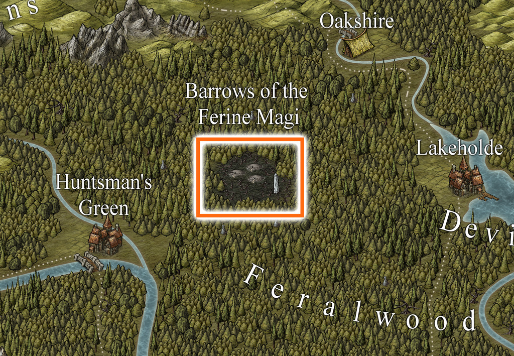
That's a big area, so from the start, I expected I'd be needing to prepare another area map, as well as that for the dungeon. Examining the Feralwood Forest map, it didn't take long to zero-in on a suitably intriguing-looking area, the Barrows of the Ferine Magi:
Since the base map for the dungeon was derived from the third of the four generated using the Inkwell Ideas Dungeonmorph "Explorer" dice set, I'd again be aiming for a similar black-and-white design look to the previous couple of dungeon and area maps in this series, including that for this new general area one, which would be done as a hex map once more. So I generated a suitable hex-gridded version of the area, from which to start thinking more about the setting:
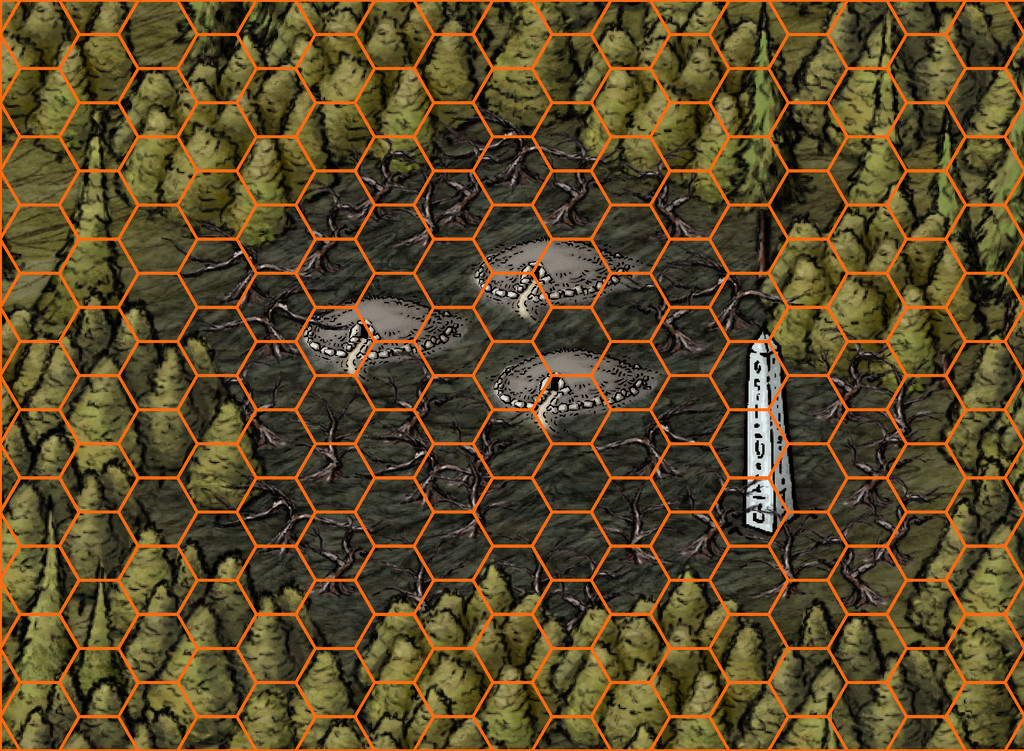
The hexes here are each six miles across in their north-south dimensions.
During the latter stages of the village mapping for the Whispering Wastes, I'd already begun thinking about what might be in this area, as there are no settlements, roads or watercourses shown, just the woods, the central region of dead land, the three barrow markers and the obelisk.
Ordinarily, I, and perhaps many of us, would assume the over-sized barrows were simply markers indicative of a large area, within which might be numerous burial mounds. However, having earlier been working with some of Ricko Hasche's delightfully pictorial maps, where the images for places and features are often hugely over-scaled compared to the physical land area, had set me wondering as to what if those were indeed to-scale depictions of the objects/places involved. An eighteen-mile high obelisk might be pushing things rather, although it could still be taller than might seem "normal". The concept of ten-mile-diameter round barrows though started to take hold.
While the dungeon map to be fitted now to one of these barrows was of the usual quite small size, that needn't prevent it being within a gigantic barrow mound. Burial chambers inside real-world barrows can be very small, compared to the overall barrow's size, for instance. The place-name and that vast tract of dead land all around the barrows also needed to be considered; wild magic from the wild magi that got out of hand in a big way, say.
From that, it was a short step to declare much of the inner zone drained and now devoid of magical energy, so no magic will work there, surrounded by a one-hex-wide ring where wild magic holds sway (the pale white circuit in the next image), and where using magic can be especially dangerous and unpredictable. This is Alarius, after all, perhaps the most magical of Nibirum's continents, so safety catch off! Outside that ring, things are more "normal", albeit creatures from the wild magic zone still might have wandered off there, of course, or indeed into the inner zone, unless they required magic to exist (a magically-powered construct would fail at the border, for instance).
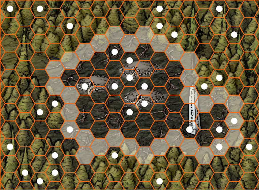
The white small circles on the image above show the randomly-chosen hexes in which there is something of note. The three barrow entrances have also been marked thus, and the location of the obelisk.
What of the barrows? Are they burial mounds, perhaps ones gigantically enlarged by the magical event that blasted the woodlands around them? Or the squashed remnants of once-soaring mage towers? Or something else entirely - such as spacecraft magically ported-in from another dimension? That latter concept intrigued, and in a greatly modified form became the basis for the eventual dungeons (yes, yes, three barrows so now there will be three identical-form dungeon maps from the dice-set base one too!). This drew on ideas from the 3rd edition "Hyperborea" RPG by North Wind Adventures (formerly "Astonishing Swordsmen & Sorcerers of Hyperborea"), whose tagline is "Swords, Sorcery, and Weird Science-Fantasy", the "Metamorphosis Alpha" RPG by James M Ward (in both its original TSR and current, largely unchanged, Goodman Games formats), and especially - thanks to its degree of oddness - Monte Cook Games' "Numenera" RPG, which runs with the concept attributed to Arthur C Clarke, that "any sufficiently advanced technology is indistinguishable from magic", in a world setting of the distant future, where tech is essentially treated like magic. That idea is also an aspect of Metamorphosis Alpha, set on a small-country-sized spacecraft lost among the stars, whose inhabitants have long forgotten they were once its crew and passengers. Thus the "magic" that still functions in the barrow-dungeons is really all technology. For anyone concerned about that in a stricter fantasy setting, I also adopted the Numenera idea that many smaller devices are one-use items. Thus things in the barrows mostly still work most of the time. Things portable enough to be removed may only work once.
So expect a degree of weirdness in the map notes to follow. You have been warned!
-
[WIP] Kingdom of Gongodûr
It can be difficult sometimes to tell what a much larger area map is really showing when you start to drill down to try and provide more detail. I often look at things like symbol titles and fill/drawing tool names where there aren't more detailed map notes (and I discovered at least one earlier Atlas map where the map notes were hidden off to one side of the map - by quite some distance, and on a hidden layer; I assume this was before things were standardised to have the text-file map notes attached separately, and as a PDF in many cases).
In the end, it's best to design what seems interesting to you that doesn't contradict whatever was shown on the larger regional map, which pretty much seems to be what you have done!

-
[WIP] Kingdom of Gongodûr
@Calibre asked: Now, tell me why those mountain ranges are as they are...
Geology! You can find an explanation for any landform that way if you hunt long and hard enough (speaking as a once-upon geologist)!

