


Wyvern
Wyvern
About
- Username
- Wyvern
- Joined
- Visits
- 3,238
- Last Active
- Roles
- Member
- Points
- 5,516
- Rank
- Cartographer
- Badges
- 24
Latest Images


-
Battle for Södermark
Nice to see this style being used for what it's intended for. I've only used it for deep undersea mapping so far!
I like the B&W version, but I like B&W maps generally, so am biased.
For the colour version, depending on how precise you want it to look, you could try making the colours, or some of them, a little more faded in some way - Edge Fade Inner or Transparency, for instance - although the way the contour lines don't align perfectly with the colours already makes it look nicely hand water-coloured.

-
[Atlas Submission] - Doriant - Gold Coast - Eknapata Desert - Kukaar
And for @Royal Scribe: I remember seeing this map quite a while back; most impressive still, even though I assumed it had gone into the Atlas back then as well!
Mind you, I'm forever finding maps by others I don't recognise when hunting for places to fit my latest Dungeon24/25/26... maps to. I suspect some probably were never posted about on the Forum, though it's at least as likely I've simply forgotten about them in the intervening years.

-
Symbols Missing, Floorplans>Wall Features>Modern Fill Wall Feature Cutting
After a bit of digging around (it's actually SS3, not SS2, which confused at first!), the SS3 Bitmap A and B styles both have wall features like doors, so will cut the walls. SS3 Blueprint Floorplans has no door symbol options, so won't have any wall-cutting tools (so that symbol catalogue comes up as blank).
It looks, though, as if you're actually using the Vector style, as in the Symbols > Modern > Floorplans Catalogue are two vector wall features catalogues Wall Features 31 and Wall Features, both of which have wall-cutting features.
For unknown reasons, using the symbol catalogue icon doesn't call-up either of the Vector Wall Features catalogues in a new Modern Vector Floorplan map I did as a test, so at least I can say it's not just your system!
You can navigate to the symbols manually, or you can add either of those files to your map using the drop down Symbols - Symbol Settings... option, which calls up this panel:
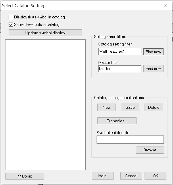
In which I simply added the word "Floorplans" after "Modern" in the "Master filter" box and browsed to the correct FSC file under "Catalog setting specifications", saved that, and the catalogue now shows up when I click the :CC2SYMPATH: icon.
Hopefully, this will help with your mapping.
@Don Anderson Jr. - The line with the horse icon will only show up if you have the various non-ProFantasy symbols from the CSUAC, Dundjinni, Bogies, etc., items installed.


-
Border Templates
Not sure about just a paper edge for something vaguely science-fiction future. The whole sheet probably should have its own look/texture - like parchment or vellum did in previous centuries (albeit still in use for high-quality or special items today).
Perhaps something like a metal scroll would be used for futuristic mapping, with the design etched into the surface, if we're thinking of similarly long-lasting, quality materials to vellum, say.
For modern paper, we have the recent Sticky Note Dungeon Annual options, of course, and further back in time, the Annual issue covering Investigation Props might be worth a look too. Note that the latter option has a ready-made computer readout background option!
-
Live Mapping: Character Artist 3
This is a very quick and dirty example of a very long-ago Monk character I ran solo back in the mists of time (about 1978?) who ended-up with a pet stirge, just using some basic CA3 options and the Stirge in a fancy circle from TT2, no labels, no tidying up, just a 10-minute rush-job:
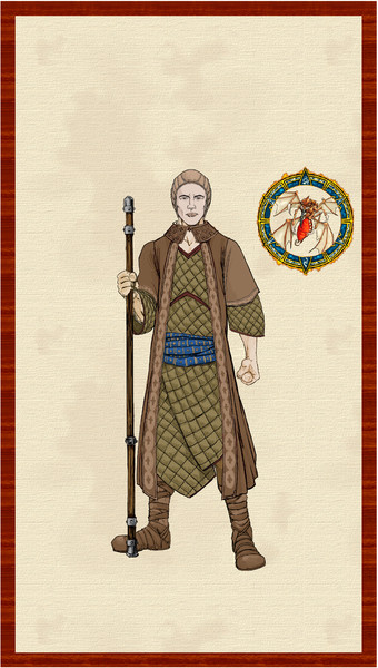
Res is lousy, but it's really just to give an idea of how you could do this for a familiar or pet - if the image exists. Slap a couple of labels on, get everything neatly centred, frame resized and fully finished, with some nice sheet effects, and it would look perfectly acceptable, I think. You could even replace the wooden rectangular frame with a fancy oval one from one of the TT sets for the main character, say!


