


Wyvern
Wyvern
About
- Username
- Wyvern
- Joined
- Visits
- 3,240
- Last Active
- Roles
- Member
- Points
- 5,519
- Rank
- Cartographer
- Badges
- 24
Latest Images


-
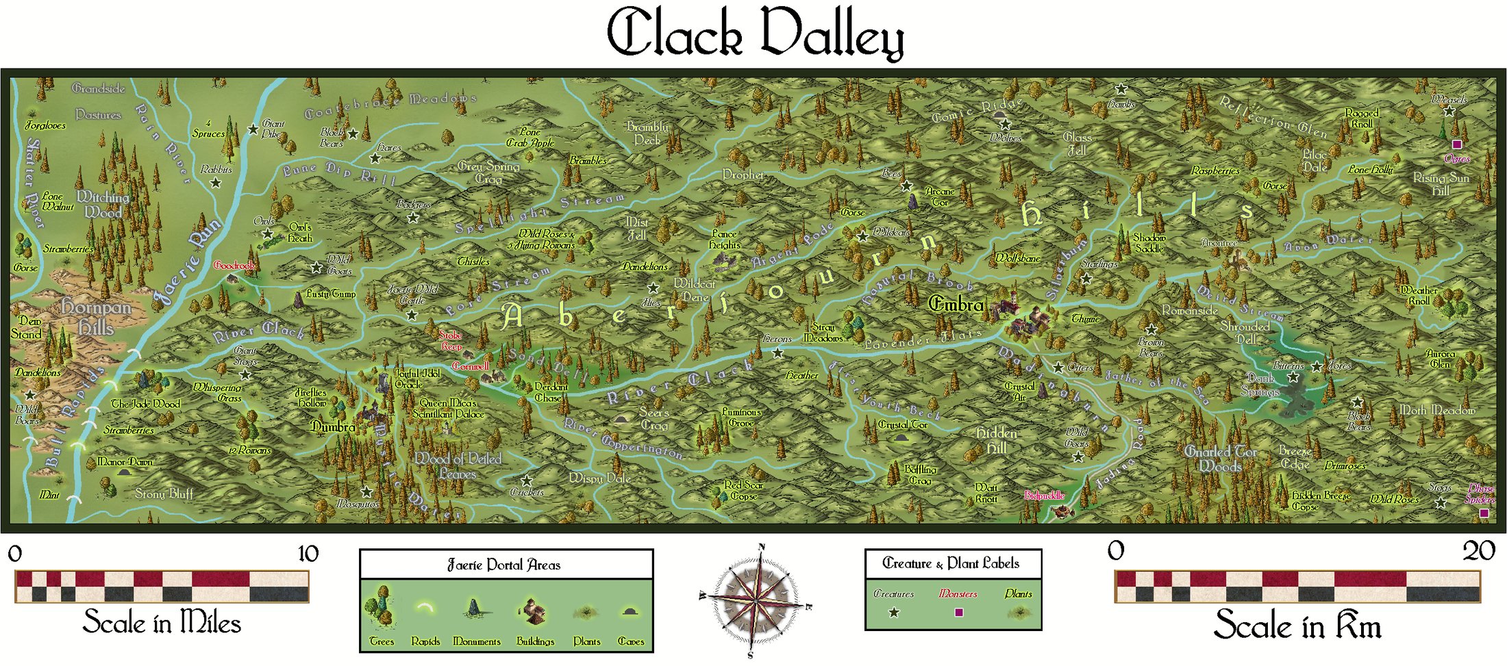
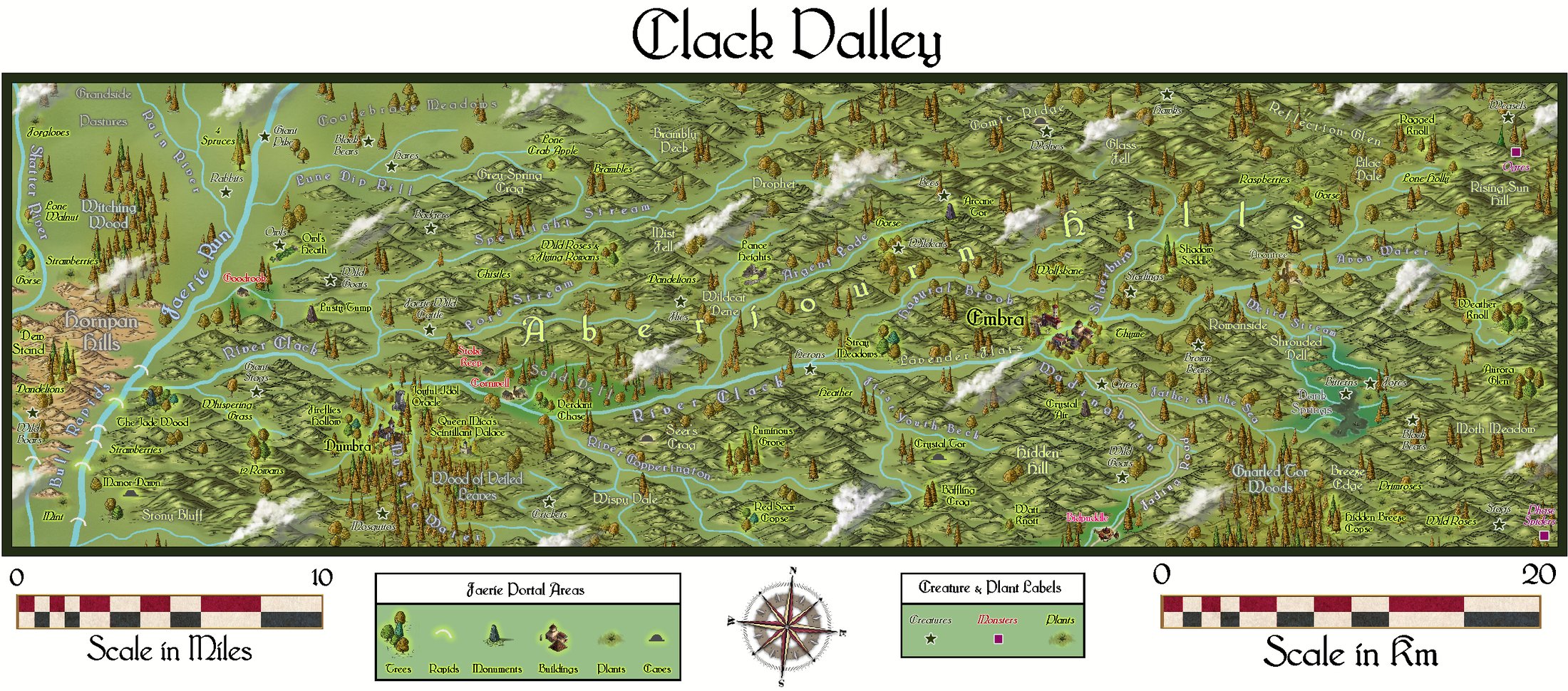
Community Atlas: Errynor Map 40 - Clack Valley
Thanks very much Sue!
Managed to upload a couple of higher-res images to my Gallery now as well:

-
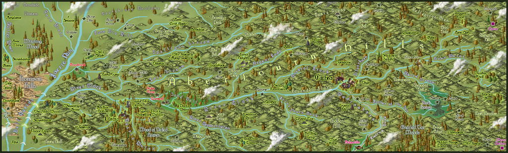
Community Atlas: Errynor Map 40 - Clack Valley
When I started preparing the Faerie Land map for the Atlas, I already knew I was going to add to it a couple of places which would require further mapping. As it turned out, both would be placed relatively near one another in northwestern Faerie Land, in the River Clack valley.
To better locate both though, it was clear a map covering a much smaller area than Map 40 would be helpful first, which is where the Clack Valley map originated. Examining what the valley looked like on the Faerie Land map, it seemed reasonable to cover the entire length of the River. From that, an area some 50 miles long by 15 miles wide (80 by 25 kilometres) would work nicely, as shown here by the orange rectangle:
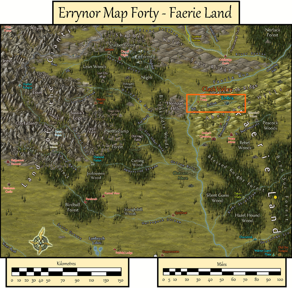
Making a hand-drawn copy of this area onto squared paper, much as I often do (see the Map 40 construction topic elsewhere on the Forum for the concept), I then drew-up some new and amended random feature tables to add fresh detail, deciding and setting the results into one-mile squares across the whole valley. From those, smaller rivers could be added in places, also drawing on the general tenor of how and where the various hill ranges had been plotted on the larger map previously. Here too, I'd decided to add a variety of random plants as well as creatures, since real-world faerie lore frequently draws attention to such things as having significance. This all helped give further character to the region.
By this stage, there was an increasing need for a host of new names to highlight some of these fresh significant places. Aside from the randomly-generated names left over from the Faerie Land map, which hadn't been used there, I'd also come across a substantial series of random-name tables on The Collaborative Gamer blog a while before, so I used those to roll-up an extra set of names to choose from, to add to what I had already. Some of the name-options on that blog are heavily Tolkien-based, which I decided against employing here, but many of the other tables read almost like a series of thesaurus entries, giving ideas even when they weren't always used in the strictly random form in which they'd been rolled. Then it came down to fitting the names to suitable specific places. After which, the CC3+ mapping could begin!
Looking through the various mapping styles of those I'd not used previously which work particularly well for handling smaller overland areas, led me to the Alyssa Faden Overland style from the 2014 November Cartographer's Annual. This is supplied with the Bridgnorth font, and that too seemed to fit with what I intended for this area.
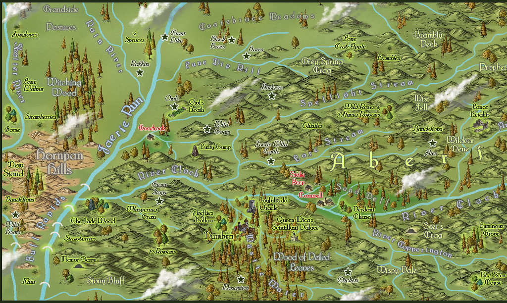
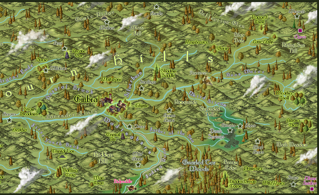
This then is the basic map:
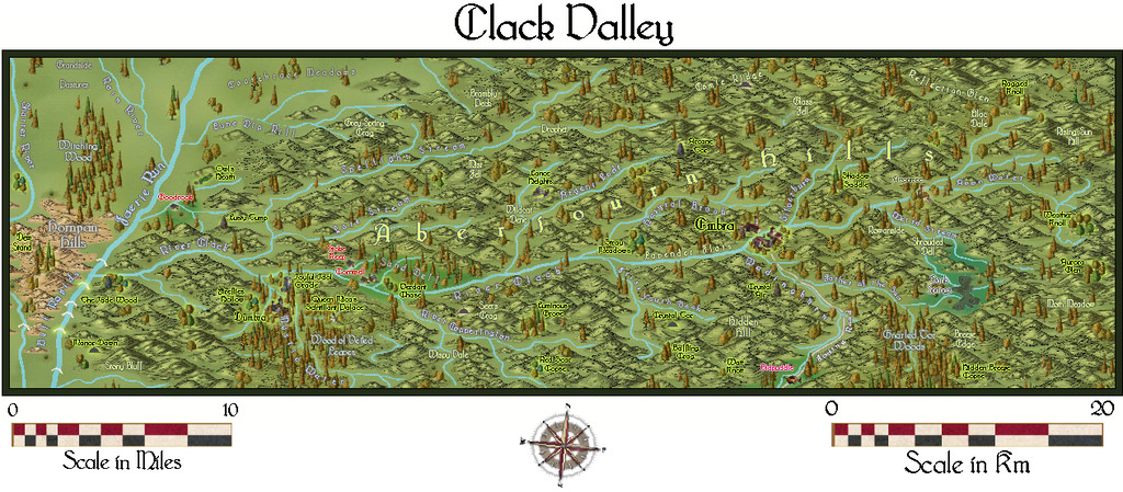
There are two small Keys to accompany it, which can be hidden separately if required, one of which brings in the extra labels and markers for the various creatures and plants added to the map:
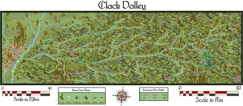
Although most of the area illustrated falls within the Faerie Land Core zone, as defined already on Map 40, a small part towards the map's left-hand edge is beyond it, as this overlay view shows, also intended to be toggleable in the final Atlas FCW version:
Part of my reason in picking this mapping style was because it comes with its own selection of cloud symbols, so I had to add some of those too:
As these are purely decorative, despite being placed so as not to conceal too much of any important labelled sites, they were set-up so they can be toggled on or off separately as well.
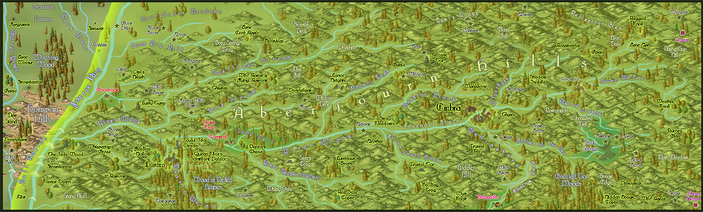
Naturally, the Forum's layout options make horizontally-linear maps particularly difficult to see much detail on, so the images below show the western and eastern halves of the map a little closer:
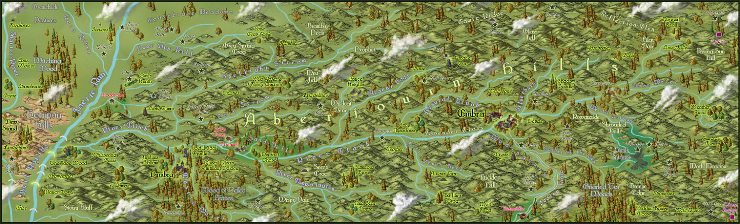
This last image is larger than the usual Forum preferred size, but it is at least complete!
The Atlas map will also be provided with the usual PDF and text file document of notes explaining more about the map's contents, and which two late medieval Herbals were drawn on especially to add a sprinkle of magic to some of those special plants!

![[Deleted User]](https://secure.gravatar.com/avatar/c75d9a245b74d9c59be0999ea81ca541/?default=https%3A%2F%2Fvanillicon.com%2F92add7f8c954488718110edc4896ad39_200.png&rating=g&size=200)


-
Suggestions for mapping a tower interior
I did some round towers with outer-wall spiral stairs a while ago for the Atlas as well in Wyvern Citadel, though you likely have more than enough, and rather better, information from the earlier posters here already!

-
Weird blocks/kinks when drawing segmented lines
It may not help in this case, but if you haven't seen it already, you may find it worthwhile to check out part of one of Remy Monsen's video mapping streams, where he addressed the issue of dashed lines not retaining their appearance if you zoom in or out to them, and how the dashes can be made to have a fixed length appearance. The relevant section begins about 32 minutes in: https://www.youtube.com/watch?v=npHHQ6vcMHU .

-
Is there a reference that gives the latitude and longitude for locations on Toril?
Monsen's right in that virtually everything that tries to equate the Forgotten Realms setting to anything genuinely geographic has been done by the fans only. Part of the problem is that the size of some of the continents were changed at different times, and as the setting developed through various novels written by different people at different times, there was never a single basis on which any of this was hung. It's extremely irritating!
Even the official TSR 1990 "Forgotten Realms Atlas" by the great Karen Wynn Fonstad shows nothing of any latitude and longitude lines, though she does demonstrate very clearly in that just how little of the planet had been even approximately mapped by that time.
The only thing I have come across is a mention on the Candlekeep.com site in their FAQs regarding a map in "Faiths & Avatars" (TSR, 1996) regarding where the equator is. I found that via this discussion post on the Forgotten Realms Wiki site, which mentions the same map shows the canonical lines of lat and long, though so far as I can tell, while there are some lines shown, none have labels attached.

