


Wyvern
Wyvern
About
- Username
- Wyvern
- Joined
- Visits
- 3,238
- Last Active
- Roles
- Member
- Points
- 5,515
- Rank
- Cartographer
- Badges
- 24
Latest Images


-
Community Atlas: Embra - Crossing Places
The last of the individual Crossing Places maps covers the part of the Twilight Market here, Slateford Market (with a second view below showing just the map, hopefully for a little better clarity at the typical Forum resolution):
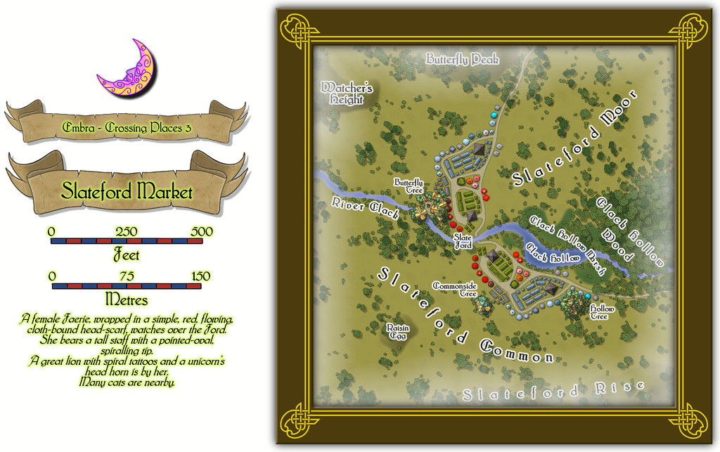
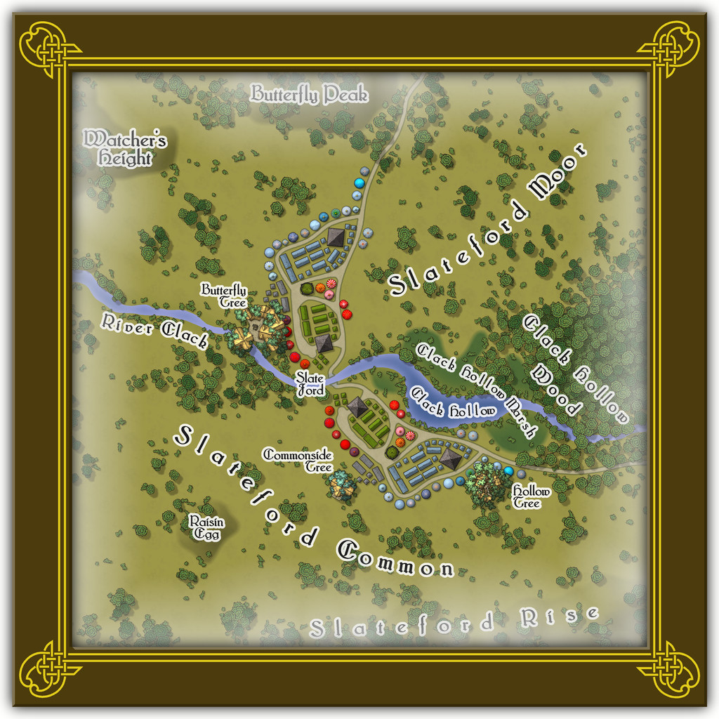
That the road layout and market stall placements look like the wings of a butterfly is not accidental. The original Judges Guild map on which this was based only had the layout on one side of the stream. It was though obvious that a simple ink-blot-style mirror image would produce this more pleasing pattern, thus this segment of the Twilight Market was designed with that in mind. Of course there's a watcher at the ford (from the featured text), and some more of the Mike Schley tree-houses, including an aerial tavern in the bough-structure overhanging the River Clack in the Butterfly Tree, "The Tasty Drop" (also a comment on patrons who miss their footing and end up in the Clack below...).
There aren't any actual buildings here however, simply tents, stalls, awnings, wagons and several open-plan covered spots (including a pair of green-tiled, circular bandstands). The thatched buildings in the treetops are intended as living parts of the trees, so aren't real buildings as such. Or that was my excuse for not providing interior layouts for them anyway!


![[Deleted User]](https://secure.gravatar.com/avatar/c75d9a245b74d9c59be0999ea81ca541/?default=https%3A%2F%2Fvanillicon.com%2F92add7f8c954488718110edc4896ad39_200.png&rating=g&size=200)

-
Community Atlas: Embra - Crossing Places
The first Crossing Place is Fountain Bridge:
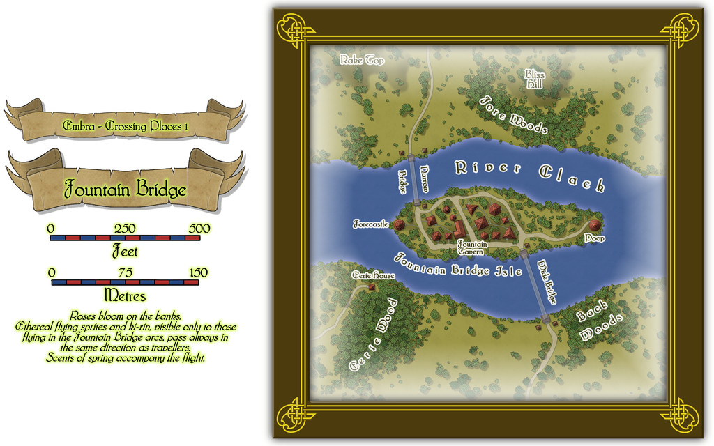
This has a small, scattered village on its central island, for which a toggle in the Atlas FCW file should allow the simple interior layouts to be seen (all have just a single storey):
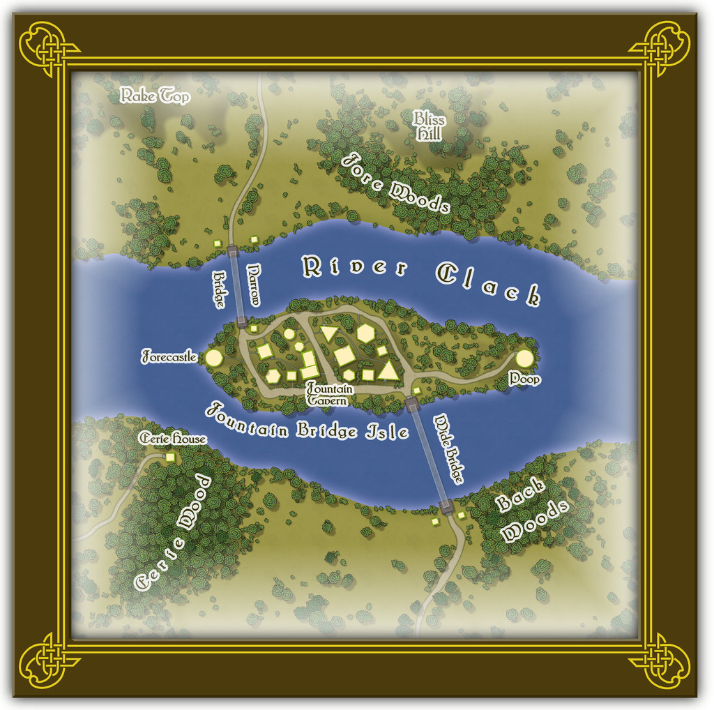
On this somewhat more detailed view, it may be possible to make out that the two bridges seem a little odd - they appear to be translucent. This is not a mistake, as there are no solid, permanent bridges here in fact. Both are literal water-fountain features. The travellers stand atop one of the square stone bridge abutments, and are then catapulted across in a gentle arc by a tremendous pulse of water. They arrive dry and safe a few seconds later on the opposite abutment - unless someone panics, in which case, they may end up getting wet, or even dropping into the river, to be rescued by the omnipresent water faeries, who think such a thing a tremendous joke! Animals - except magical or Faerie types - cannot use the bridges at all, however. Text and PDF files explain a little more, although Eerie Wood and Eerie House remain as mere mysterious names, to be expanded only should GMs wish to do so.

-
Community Atlas: Selenos, Statrippe, Artemisia
And so lastly, we have the dungeon, linked by a rubble-hidden trapdoor from area B2 in the Castle, Crabwell Delve:
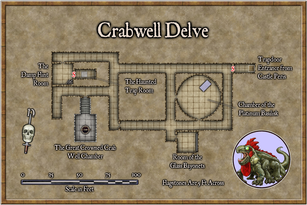
Jon Roberts Dungeon again, with a hint of Token Treasury 2! A nice, simple layout, and while it would have been pleasant to have more symbol options, a top-view statue of a Platinum Basilisk was always going to be unlikely, together with a gigantic Crowned Crab statue to fit over the top of, and around, the well. Hints of magic, fun and weirdness to be found in this long-abandoned, indeed long-lost, piece of subterranea, however, courtesy of those Story Engine card decks!
Next time, I'm apparently staying in the tropics, if a bit further south, to visit somewhere on the large island of Ethra in southwestern Doriant...


-
[WIP] Community Atlas Competition - Runcibor Dungeon
@Quenten asked:
I will probably change to X-section to show joining passage ways, by bending the red line - can that be done, ie would it be stupid to do it?
It's pretty much standard practice in a lot of real-world cross-sectional mapping to vary the line direction like this, often to follow a specific passageway, or series of linked passages and caves. The purpose of the cross-section is to provide useful detail that's not so easy to identify on the plan-view map, so any line that works best to show that is appropriate.
Indeed, if you take a look at the PDF mapping guide for CA7, Caves and Caverns, this is exactly what Ralf (I think?) did in drawing the sample cross-section for that cave using the modern cave mapping style.
Sometimes, it may even be helpful to use more than one such cross-section.
Looking at the cross-section on your first map above here, while it's interesting, in pointing out how variable the levels are in different parts of the cave system, it's not all that helpful, since it implies other parts of the caves may be at similarly variant levels, without indicating what those may be.
In some cases this may be of merely academic interest, where caves aren't directly linked to one another and are some considerable horizontal distance apart, for example. However, where the passages and adjoining caves are at different vertical levels, it can be much more important - i.e. if a passage enters in the ceiling of the next cave, say.
It may also be useful to add some cross-sections of individual passage segments next to the area on the main plan view too. For instance, there are a couple of clear choke-points towards the SE end of the narrow, SE passageway. This suggests they're more or less impassable, yet there's a mapped cave beyond them, so there must be a way through, if perhaps only a crawl-space. A cross-section of just the choke-points on that passage next to the narrowest parts would help clarify that.
-
Community Atlas: Embra - Constructed Places
Thanks very much everyone!
And on Quenten's point, the odd thing is the Character Artist portraits take hardly any time at all, by contrast to other types of map.
It is a shame that Character Artist doesn't get the same kind of updates and additions other parts of the CC3+ program suite do; some variant body and face shapes would be interesting, for instance, though I appreciate that would add a lot of extra work, fitting the various costumes and weapons, etc., to such alternate forms. Still, if you don't ask...


-
Community Atlas: Embra - Travelling Places
Travelling Place 1 is Toll Cross, which as we see, is an unusually heavily built-up area, surrounded by dense greenery, beyond which is open grassland or moor:
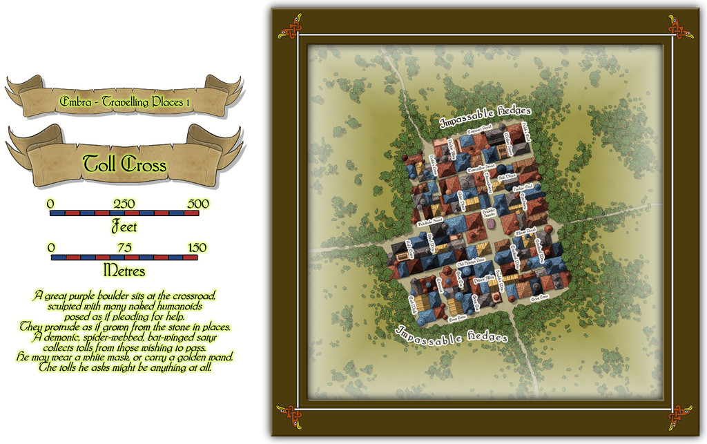
While the base-map was a similarly heavily-urbanised area, the nature of Toll Cross (and indeed even its final name) derived chiefly from the accompanying featured text, and especially that demonic satyr figure. The Impassable Hedges mean anyone wanting to visit the shops or houses here, or even just pass through it directly as a crossroads, is channelled into using one of the four access-routes. Then I adjusted the layout of the buildings slightly in places so those on foot can get to only a fraction of the properties inside unless they pass through the central Boulder Square, where Guess Who waits, like a spider in a web... This view is with the labels turned off to get a better impression of the settlement:
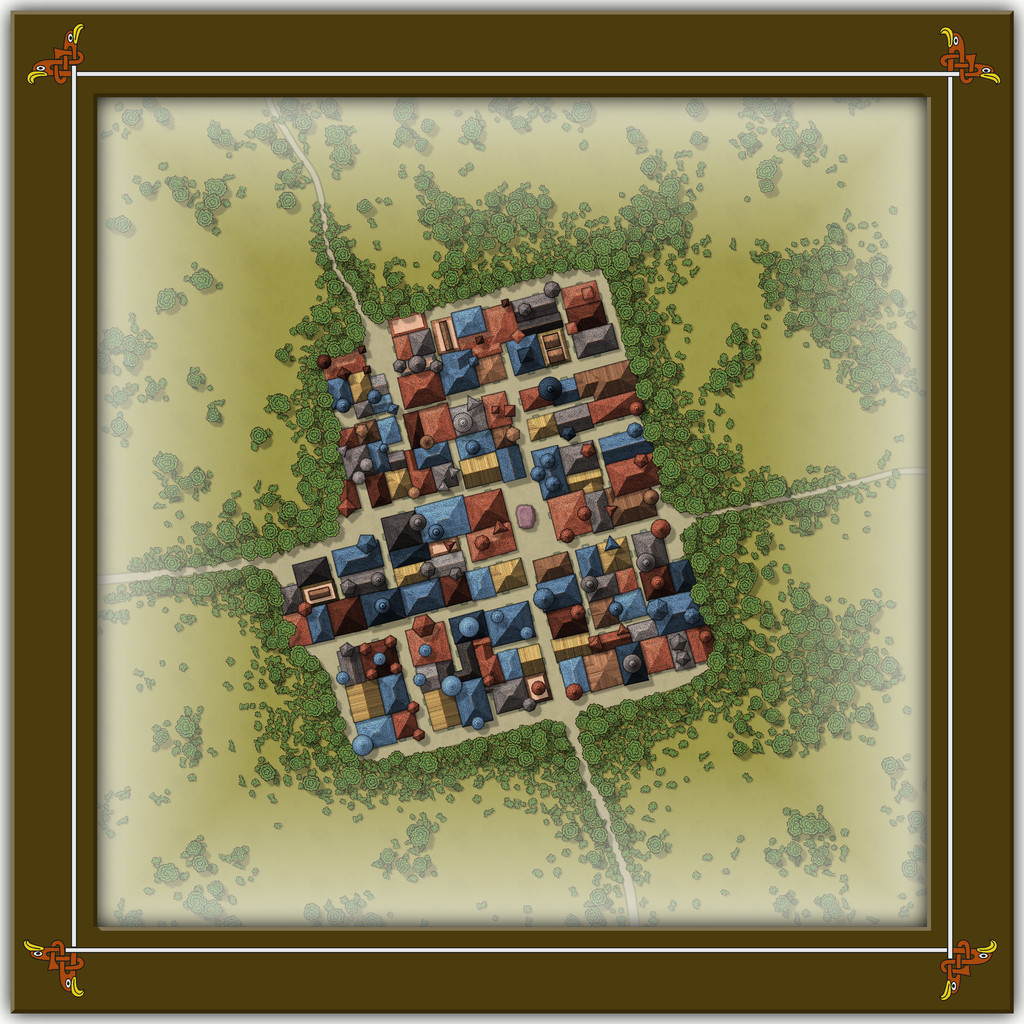
This looks a bit odd (or at least, it's meant to), with some strange rooflines, and what seem to be many towers. An extract from the accompanying text and PDF file may help explain:
There are...many tall spires and tower-like structures of different sizes and forms, some of which are visible above the trees from outside the settlement. These features are all entirely solid, and appear to have simply grown from the roofs and upper walls of the buildings. Few are straight, and many could pass for horns. Quite a number of roofs overhang their properties as well, and can give the impression of being ill-fitting, or as if they were worn as wigs that have slipped slightly. The whole can be quite unsettling for those not used to Faerie, and even those visitors with Faerie blood may feel there is something a little off-kilter about Toll Cross.
Despite the range of building shapes and sizes, they all have just a single accessible storey at ground level inside, as the toggled view to show the building interiors indicates:
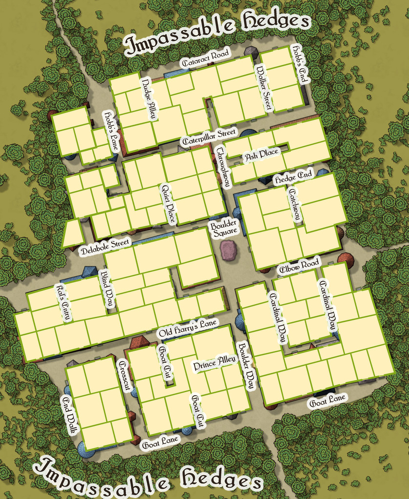
This also shows just how much some of the rooflines, and particularly those horn-towers, don't marry-up with the building outlines, yet the buildings, thanks to their lack of internal connections, further help block any attempts to avoid using Boulder Square. And if you try to fly in, it turns out those roofs aren't so immobile as they may appear...

-
Show me your science fiction maps!
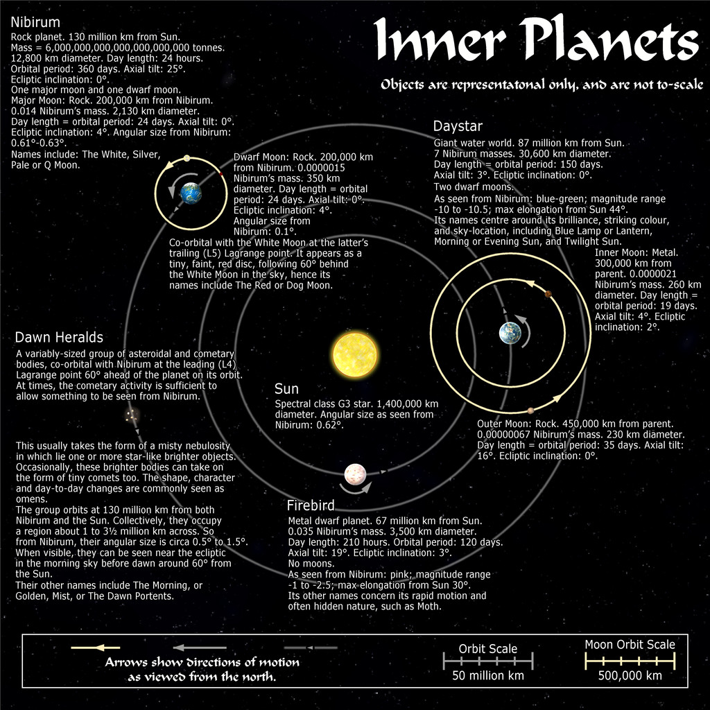
Not sci-fi, since they were all done for the Nibirum Community Atlas, which is all fantasy mapping, but they were done in the general style of planetary-system mapping, so may still be of interest. However, I did a series of maps for said Atlas back in 2018 - Forum thread here, Nibirum Solar System start page here, with a sample map to give you an idea, just for the inner planets:
All these maps are also in my Forum Gallery here.


-
Postcard Maps
In my accidental "voyage of discovery" of non-standard maps this year, following my learning of the playing card maps highlighted here earlier, recently I came across some old UK annotated postcard maps, not least one that the H P Lovecraft Historical Society reprinted as a physical prop with one of their series of 1920s-30s-style audio programmes, "The Iron Maiden", published early last year. Mostly, these "Dark Adventure Radio Theatre" shows are based on the works of H P Lovecraft and similar horror writers of that period and before. The prop in question was this map of the Isle of Wight off the south coast of England, from the 1920s:
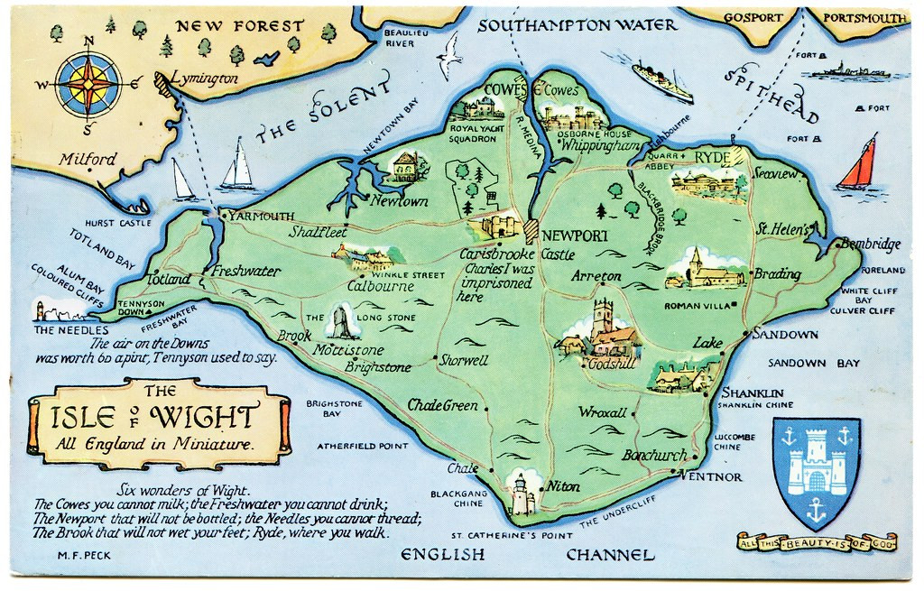
This style of map could be quite easily drawn using CC3+, and I particularly liked the annotations, as elements it would be easy to add to such a small-area map to inspire adventures in a fantasy setting, notably that short list, the "Six wonders of Wight".
Again, like the county playing card maps, this could be something readily adapted for RPG mapping use, I think, to give a fresh twist on how they appear. Of course, a dedicated style, with suitable feature symbol illustrations for CC3+, wouldn't go amiss either!


-
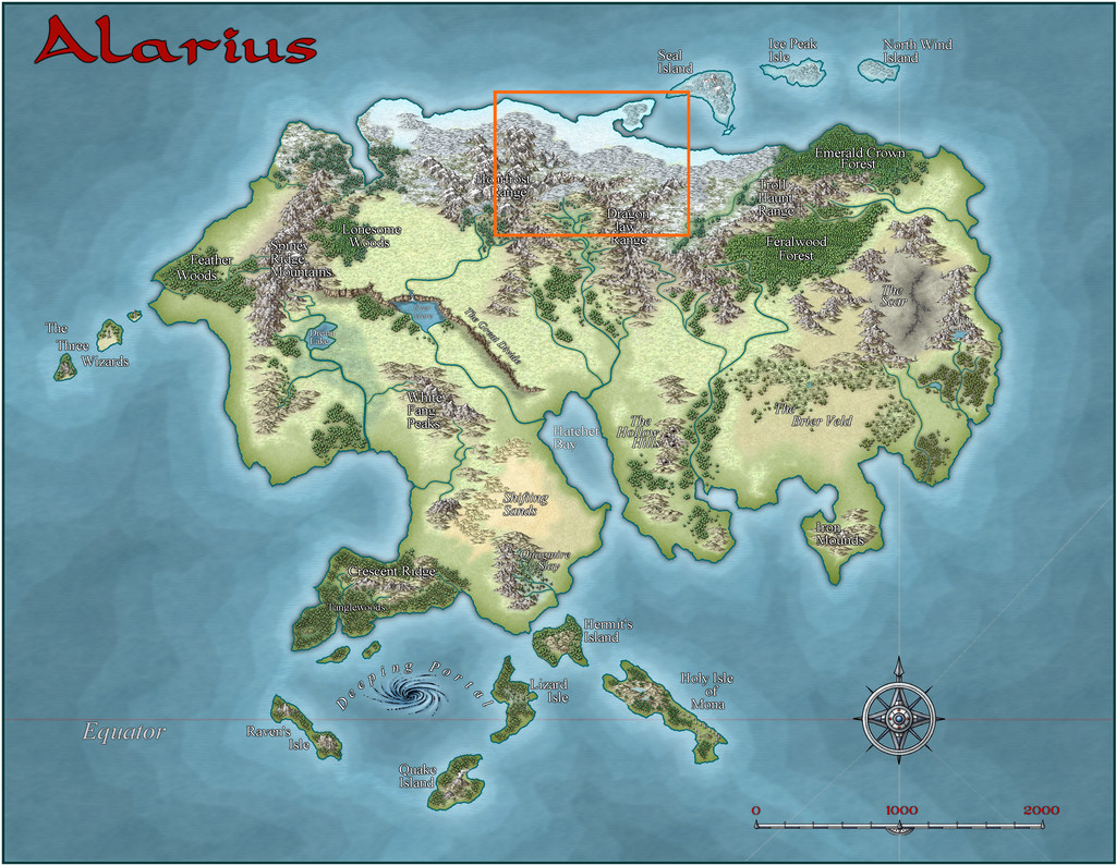
Community Atlas: Petroc Hills area, North Central Alarius
As mentioned with my previous map in this series (Gruvrå's Mine in Peredur), for the next, I'd be returning closer to my "home" territory in Alarius, as the map chosen to place this one in was the Alarius North Central region:
The base map from the Inkwell Ideas geomorphic dice rolls was another using just two designs from the "Delver" set, so I checked the Inkwell book for these (the "Dungeonmorph Book of Modular Encounters: Delver, Trailblazer & Voyager Edition"), finding there an interesting group of suggestions of which I ended-up using rather a lot in the final map and accompanying notes. They also influenced where the map could be placed within what is really a vast area of Alarius.
Indeed, several smaller maps have been set within the Alarius North Central region already, so I checked those. As I couldn't find quite what I was looking for among them, I decided to pick a fresh spot suitable for a new area map, on the edge of the large agricultural basin around the Elm River's headwaters (that's the river large and important enough to be shown even on the continental map above). In both the next images, the orange-outlined square of my selected area is 20 miles per side:
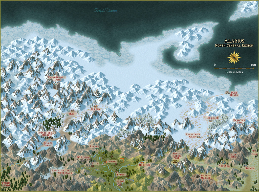
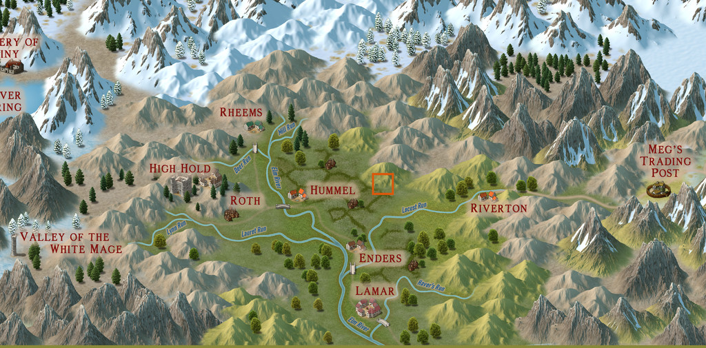
This is right on the edge of the "civilised" lands here, around 56° N latitude, and from the appearance of the terrain, a cool temperate spot, but not iced-in year round thanks to being sheltered by the mountains surrounding the fertile riverine plains. Then I devised a hand-drawn graph-paper map for it, with the main terrain types sketched-in, and randomly rolled up some feature options, this time chiefly using just my own random tables. These in turn led to the main watercourse layout, based on where the settlements and other points of interest were. During this process came a realisation that there were quite a few "awakened plant" and "interesting wildlife" features which fitted nicely with the loose druidic theme already generated from the Inkwell Ideas dice book.
And so to the CC3+ mapping. Following my attempts in recent maps of this group to combine more-or-less matching overland and dungeon styles, I thought it would be worth trying-out the Jon Roberts overland and dungeon styles, using the Cartographer's Annual 190 Jon Roberts Revisited overland style for the small area map:
So, welcome to the Petroc Hills! After finding I'd be having giant eagles on this map, I decided the local dialect term would be "petroc" for them, as meaning "small" or "little" roc (= gigantic bird), which also accounts in part for the repeated reuse of "roc" and "rock" in the names (because the pronunciation's the same!). As luck had it, the random locations for some of the settlements on the farmland were close to the map's southern edge, and I decided to site them right on, or extend them slightly over, that border, helping to reinforce that edge-of-civilisation theme. Plus I dislike having maps of this sort which show too marked an "edge of the world" effect. Thus of course, many hills are just peeping onto this map from beyond it too.
I found this style a delight to work with, as the terrain symbol drawings are of such high-quality, they can be greatly enlarged, yet still look superb, and I was especially pleased to find that by rescaling the farmland bitmap fill, the pattern in it would work perfectly for each diamond shape to represent the size of an individual farmstead or family group of smallholdings at this scale, without having to include every farmhouse. When it came to naming the features so-mapped, I found just the hill shapes and forms to be sufficiently inspiring, without having to resort to random tables for their names, and in some cases, their characters. And I did like that pastel grey-green, watercolour-like colouring; very restful 😎 .
However, the style's range beyond the non-terrain symbols is rather restricted, with just a single fashion of settlement types, and some basic trees, so I also used some of the Mike Schley, Herwin Wielink and standard CC3+ overland symbols to indicate others of the special features. Most don't seem all that out of place here, luckily.
For those interested in such things, most of the settlements are predominantly Human in population, although there is a sizable Hill Dwarf community in places (their main settlements are at Appleby, Strawberry Fields and Furzeholm), along with features such as a glassworks in the Strawberry Fields area and apple orchards at (naturally!) Appleby, while most places - even some of the small farmsteads - have their own minor breweries and distilleries, as the whisky from places here is highly prized elsewhere.
Out in the wilds, we have stingbats (that phrasing a minor in-joke for any Shadowdark RPG enthusiasts 😊), which are essentially the blood-sucking, small bat-like creatures called "stirges" in D&D, griffons, cave bears and wild boars, aside from the giant eagles, and also a community of Stone Trolls at the top of Stoneman Vale on the great hill of Stony Heights (also called Griffon Hill). Stone Trolls here highly prize certain kinds of stone, and especially jealously guard the magical Jewel Tree in "their" Vale (it fruits genuine gemstones each autumn).
And right in the middle of the map, at the foot of Rosebud hill, we have Rosebud Caverns, the little underground complex, and cause of all this mapping...


-
[WIP] Community Atlas, 1,000 Maps Contest: Villages in The Whispering Wastes of Haddmark, Peredur
Hex 005, Ljungby Village. There is no established pattern for settlement maps in the official Shadowdark supplements as yet. Individual buildings and small groups of structures tend to be shown on maps identical to those used for subterranean areas, without illustrating the broader regions beyond them. Naturally though, in selecting something suitable for the Atlas, I was going to stick with a black-and-white style, and selected the Annual 100 Black & White Towns option as suitable for all these smaller settlements.
The Shadowdark main rules do provide random systems for generating settlements and places of interest therein however, including the general layout for roads and districts, which is what I used for all the settlements here, although because I'd already mapped the surrounding region, some adjustments and additions were needed. These systems don't provide details on population size or the number of non-interesting buildings, so for those, I turned to an old standby, my trusty, if slightly worn, "Village Book 1" from Judges Guild back in 1978, as this has mechanics to generate numbers of shops, etc., based on a randomly-rolled population size. I simply back-calculated a rough population size based on the points of interest already chosen, which allowed me to estimate a number of additional properties for each place.
I ran into a few difficulties with the chosen mapping style, as the Grass and Road Dirt bitmap fills come out very weak and faint (the Road Dirt one especially), and are scarcely visible on an image of the map, despite experiments in adjusting the settings. The alternative road tools use the Road Stone fill, which is somewhat harsh. As I wanted the roads to look more like tracks here, I compromised on something that could be seen on the final image OK, if still looking a bit too "stony", by adding a Transparency effect to fade the lines down, without using the original Edge Fade, Inner effect, as that seemed to be part of the problem making the Road Dirt fill effectively invisible.
Symbols for the buildings needed tweaking to get them to reasonable sizes (the standard size for some is fine for sheds and similar, but a bit too small for houses), and the typical problem with a number of the "City" styles cropped up, in that houses drawn using the drawing tool stand out far better on the map than those from the symbol catalogue. I simply drew the buildings that needed highlighting with the drawing tool, saving the symbols for everything else. Chimneys were added by-hand, helping to indicate occupied properties (sheds and barns were left without). The area is about 69 degrees South latitude after all, so no chimneys was never an option!
This style uses the AquilineTwo font as standard. However, I found this wasn't clear enough to properly read the labels, so switched to Primitive in all cases here, which meant amending two of the symbols as well, the scalebar and the compass indicator, to switch fonts. With luck, this all should mean the subsequent maps are a little easier to achieve.
And so to Ljungby itself:
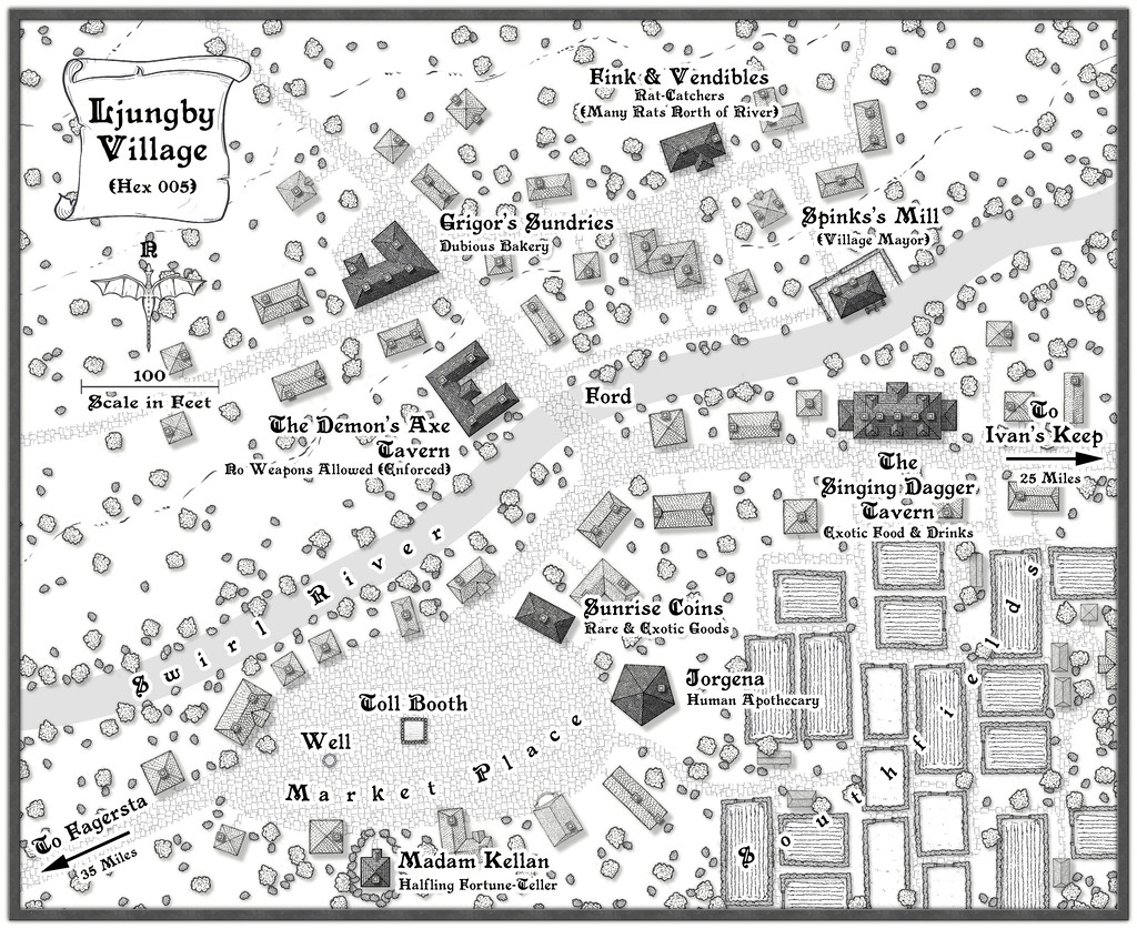
One advantage with using Transparency on the road fills, is it makes the ford on the Swirl River look more "ford-like". I also chose to add the series of small plots in the lower right corner as the start of the nearer farmlands, and to represent small-holdings used by the villagers. There are a few sheds and barns scattered about there as well. I found adding sheds nearer the village proper started to make it feel too cluttered, with the scatter of trees and shrubs. Adding some sketchy contour line symbols north of the river helped indicate the land was rising that way, for all these need to be placed as free from other map features as possible, or they quickly become lost - hence why there isn't another south of the river. The eye's natural tendency to fill-in gaps helps the illusion here.
The other significant additions beyond what randomness had provided included the mill, with the miller promoted also to be village mayor. There's a dodgy bakery (which rumour has it may be the source of the rat problems north of the river...), so I felt a mill would be useful as well. The Market Place was a bit too blank, so it received a Toll Booth for collecting tolls from the market traders, and a well for arriving draught animals.
Only nine more to go!

