Monsen
Monsen
About
- Username
- Monsen
- Joined
- Visits
- 660
- Last Active
- Roles
- Administrator
- Points
- 8,858
- Birthday
- May 14, 1976
- Location
- Bergen, Norway
- Website
- https://atlas.monsen.cc
- Real Name
- Remy Monsen
- Rank
- Cartographer
- Badges
- 27
Latest Images


-
Question about the sheets.
Basically yes. You can consider sheets a feature for visual grouping/ordering (+ effects), while layers are logical grouping.
Layers only end up important if you actually use them though. Having everything grouped according to feature, such as one layer for hills/mountain is nice and all, but if you never use the features layers provide (select by layer, hide layer, freeze layer) it becomes less important. I do find it useful to be able to select things like all the mountains though, for things like sorting symbols. While the layers doesn't themselves determine what goes on top of what, the ability they give you to select just the correct symbols is nice.
Layers are actually more important for the interlaces of the software than sheets though. For example, dungeon corridor tools rely on layers to figure out what is a floor and what is a wall when connecting to existing parts, cutting symbols rely on layers to align to and cut that wall when inserting a cutting door, and the edit feature of drawing tools relies on the layer to determine if this is an appropriate entity to edit, the background of the map is figured out from the BACKGROUND layer, and the extent of the map is determined by entities on the MAP BORDER layer to name some.
Usually though, tools set their own layer when you use them, so you don't really need to keep to much an eye on that yourself. If you create your own tools and symbols, you should always set up layer information so your own tools can also set layers automatically, but unless actively use your layers manually, it is usually just fine to then let the tools do their thing, but don't otherwise think too much about it.


-
August Mapping Competition - Building Floorplans - Win Prizes
Time for a new mapping competition. I hope as many people as possible can join in. Competitions are a great way of testing yourself and making something new. If you are short on time, pick something small and easy, participation is the main goal. And please compete even if you don't need the prize, competitions are more fun when many people participates.
Theme
So, the theme of this competition is building floorplans. More precisely, you will be making building floorplans for buildings in the city of Vertshusen from the Community Atlas.
The idea here is that you pick a single building and map it (or a few buildings if the other buildings belong to the main building, like outhouses, sheds, stables, etc, but the idea is to map a building, not a street or square view). The idea is to map the buildings from that map, so you are expected to keep to the general shape of the house you pick, but you are of course allowed to add additional details that are to small/insignificant to show up on the city map.
How to Participate
All you have to do is to make a CC3+ map of one of the buildings inside the city walls and post the exported images here (see below for map requirements and restrictions).
You are recommended to maintain a Work In Progress (WIP) thread showing your progress on the map, but this is no requirement, it's just fun to see the process. And it is still allowed to ask for feedback even if it is for a competition.
However, I do hope as many people as possible will also submit their competition entry to the community atlas. This is NOT a requirement to participate, but it is very much appreciated if you do. And to ensure people mapping for the atlas don't do the same building, I kindly ask you to reserve it first by simply claiming it in this thread. To claim it, simply edit the cropped image of the city below, mark your building clearly, and post the modified image. The claim belongs to the first one claiming it, don't wait for any confirmation of the claim. Of course, if you don't intend to submit your map to the community atlas, you don't need to claim a spot first either. And of course, when you are submitting to the community atlas, I also need the .fcw file. You can post this with your entry, or send it to me later.
Restrictions & Requirements
- The map must be made wholly in CC3+. No pre or postprocessing.
- Only artwork from official add-ons allowed, as well as the free artwork resources listed here. No custom symbols or artwork found elsewhere. (Edit: I realized after starting the competition that there was also a few links at the bottom of that page to other interesting art resources, but that are not properly integrated with CC3+. I won't change the competition rules midway through, but be aware that I cannot accept maps for the community atlas that uses these resources, only the resources listed int he first section - "Free Addons" - can be used for maps that go into the community atlas)
- The building should be one of the buildings inside the city walls of Vertshusen. All buildings are up for grabs, numbered and non-numbered, but for the numbered buildings you are obviously expected to stick to what the label tells the building is, while for unnumbered you are free to make the place whatever you think fits
- Your entry should be a single main building, but including buildings belonging to the main buildings like outhouses, sheds, stables etc is allowed. This means you can for example claim two buildings next by each other and say it is an inn and the connected stable for example, but you should not map several unrelated buildings. It is up to you how many floors the building will have, and it is up to you if you map all floors on a single map file next to each other, or if you use multiple files.
- The building floorplan is the main objective, it's up to you how much focus you will have on the outside of the building (garden, street, corners of other buildings sticking into your area, etc)
- Try to consider what the building located there would actually be/include. Probably won't be a farmhouse or windmill inside a city for example.
- Keep in mind that the city map is in metric when measuring the size of the houses to determine the size of your floorplan. You're free to make your floorplans in either metric or imperial, as per your preference, just remember to convert the size if you use imperial.
Time Limit
The contest ends on September 1st, 23:59 UTC. All entries must be in before that limit to be eligible for prizes.
Prizes
There are four prices available, in the following categories. Each person is only eligible for one prize, if the same name shows up multiple times, the prize continues on to the next in line. Same happens if someone declines their prize (like if you already own everything and don't have anyone in mind to give it to)
The top prize is a $50 store voucher provided by ProFantasy
Best Building - In this category, the best complete building is considered, with all floors. The building may consist of one or more map files, they'll be judged as a whole, and winner determined by community vote
Then we have three products gifted by Steve Smith. They are Cosmographer 3, Source Maps: Cities and Fractal Terrains 3. The winners of the following categories can pick their desired price from these three, pick order in the order listed below.
Most interesting floorplan - In this category, the winner will be the entry with the most interesting floorplan. This is judged per floor, not for the complete building. Judged by community vote.
Random Draw (x2) - We will also draw two random winners from the participants.
The Community Atlas
The community atlas is a collaborative world-building project. The city of Vertshusen is one of the cities in the atlas, and with this competition, we declare it the community city project for the atlas, which we are trying to map the floorplan for every building to flesh out the entire city. So please feel free to submit additional floor plans to this city at a later stage, also after this competition is done. Vertshusen vas chosen because it's size make it a realistic project to complete over time, and the map size ans style allows for individual buildings to be identified without resorting to district or street views.
Note that while Vertshusen is a community atlas city, you do not have to contribute to the community atlas to participate in this contest. Only people who submit their .fcw files will be included in the atlas, so you don't need to do anything in particular to not be included, but of course, we hope that as many participants as possible also contribute their entry to the atlas.
![vertshusen%20city[1].jpg](https://forum.profantasy.com/uploads/633/CGM4DK17SJC5.jpg)
Good Luck!


![[Deleted User]](https://secure.gravatar.com/avatar/c75d9a245b74d9c59be0999ea81ca541/?default=https%3A%2F%2Fvanillicon.com%2F92add7f8c954488718110edc4896ad39_200.png&rating=g&size=200)
-
Mapping Humor


-
Testing some anti-spam features
Hi everyone,
I am just testing some anti-spam measures. Ideally, no one should notice anything at all, but if you for some reason get the message that your comment will be posted once it has been approved instead of just appearing immediately, this is why. Rest assure that if it happens, I will approve your comment as soon as possible.
Now, please be aware that this should not happen to established users (rank newcomer or above), so if it happens, it will be because something is not working as intended. (This is why we test, right?)
Ideally, new users shouldn't notice anything either, but if your post is classified as potential spam, it means it goes to moderator review before being made public. My goal is to have as few of these cases as possible, because I know how annoying that is as a new user to encounter a mandatory spamblock just because you are new.
I would also remind everyone that the way a user is promoted up the ranks is by post count and points combined. Points comes from reactions (Like, Awsome, Insightful, LOL). It is therefore helpful if everyone refrains from helping spammers up the ranks by giving them reactions. This is mostly a problem when people give reactions to someone just because they post an introduction post and say they are new. If they actually say something sensible (gives a good introduction, says something about mapmaking, etc) by all means, go ahead and give them that like, but if their introduction is completely generic ("Hi, I am new", "looking forward to talking with everyone", etc..), please give the reaction a pass, otherwise you are more likely to aid a spammer bypass measures rather than send a kind signal to a new member. (In the latter case, maybe post a reply challenging them to tell something about their mapmaking instead, that way they both get a welcoming reply, as well as being tested)


-
Converting old CC-DOS maps to CC3+
Not reliably. The old CC-DOS used a list of numbered fonts. I can tell what font number they used, and if they used the default font list, I can do some assumptions from that, but I already know they didn't use the defaults thanks to the Symbols2 font which I had to manually add to position 7.
Arial is just a placeholder when the actual font is not found. I can guarantee that the old maps did not use arial, but due to the limited resolution in DOS, maps would tend to use mostly plain fonts.
Here is an export of the Sebrun map from CC-DOS, which you can compare to the CC3 result below. Mostly very similar, but you can pick out a few small differences.
I've put hi-res version of these in my gallery, but because on heavy reliance on 0-width lines, this makes them look horrible when zoomed out, but you can appreciate the detail when looking at them in 100% zoom (hint: middle click the thumbnails in the gallery to open the map in a new tab instead of the gallery viewer, this allows you to use the browser's zoom capabilities)


-
Live Mapping - Thursday 19:00 CET - SS2 Dungeon with a twist
For tomorrow's live stream, I will be looking at creating a dungeon with Symbol Set 2.
Click the video below to access the reminder button. The stream will be at Thursday, October 1st, 19:00 CET. Access the video below to get the time in your timezone.
Hope to see you all there.


-
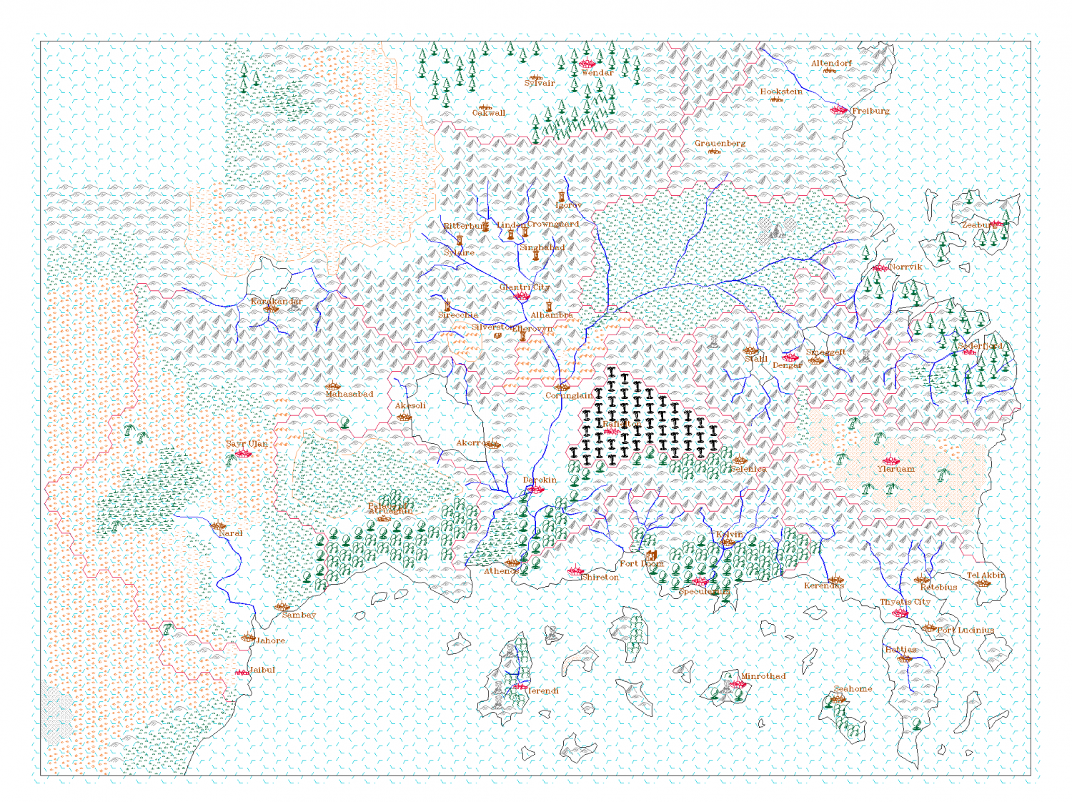
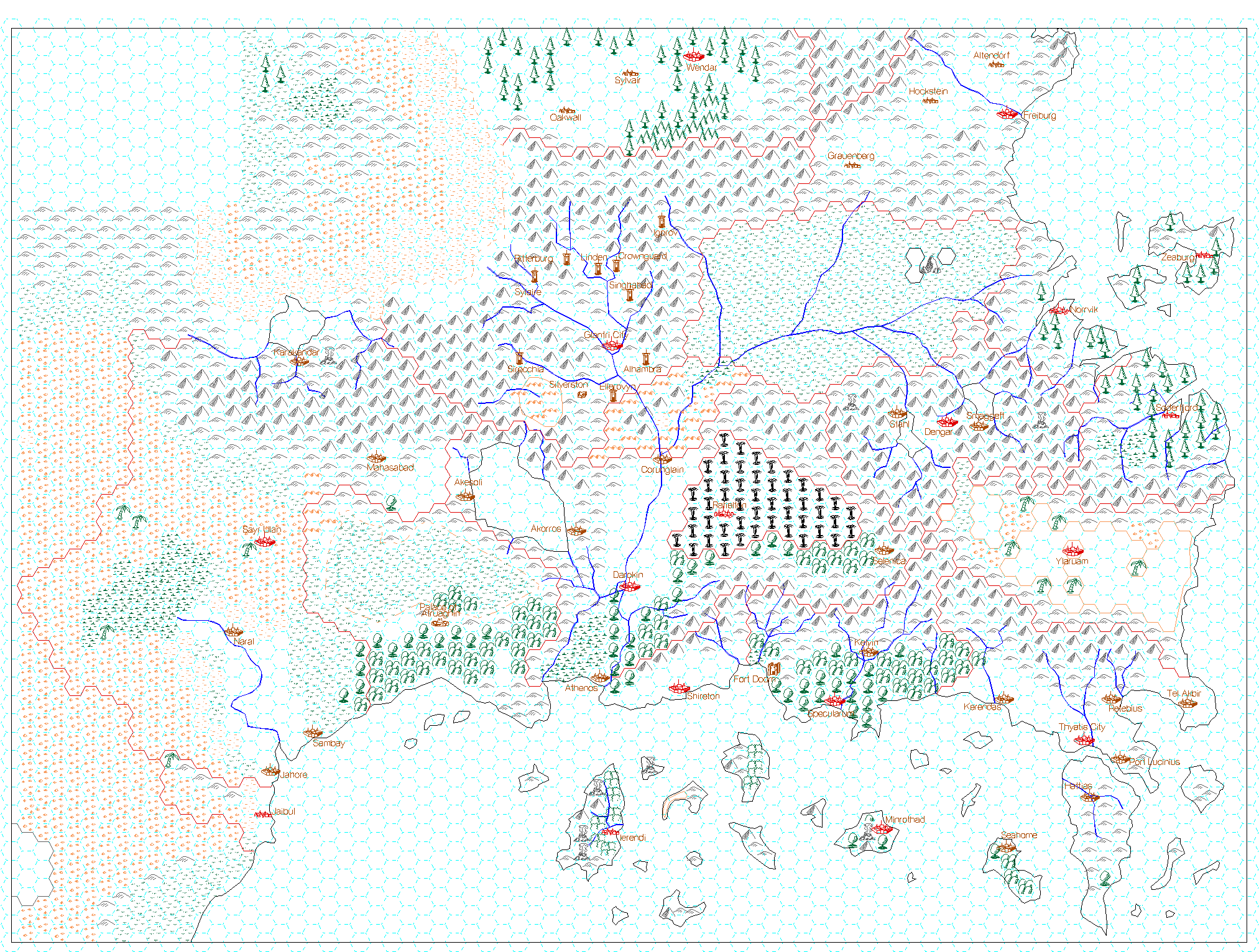
Community Atlas Project - Download information - Contributions Welcome
 The community atlas is a project where the ProFantasy community
comes together and map out the complete world of Nibirum for everyone to use. Here,
we provide all kinds of maps, from world maps to continent maps to area
maps to city maps to dungeon maps and much more, and they are all
hyperlinked together in an interactive atlas.
The community atlas is a project where the ProFantasy community
comes together and map out the complete world of Nibirum for everyone to use. Here,
we provide all kinds of maps, from world maps to continent maps to area
maps to city maps to dungeon maps and much more, and they are all
hyperlinked together in an interactive atlas.
Anyone who wants to can download this atlas. The files in it are in the Campaign Cartographer 3+ map format, meaning you can easily edit the maps for your own use, to make the maps better fit your world, or you can just use it as it is, either using individual maps, or just adopt the world mapped in the atlas as your own campaign world. You can also use the maps for inspiration, and examine them to figure out how they were made. And all the maps are hyperlinked together, meaning you can navigate through the world, they are not just a bunch of random maps. The
maps in the atlas are mapped by a wide variety of community members of
different skill and style, and the maps in the atlas reflects this as
well. And we are always looking for new maps to the atlas, so please
consider contributing. Contributing to the atlas is a great way of
testing out that latest annual style you wanted to try, to experiment
with your styles, or just get some additional mapping experience. And
everyone is welcome to contribute, you don't have to be a CC3+ expert.
The
maps in the atlas are mapped by a wide variety of community members of
different skill and style, and the maps in the atlas reflects this as
well. And we are always looking for new maps to the atlas, so please
consider contributing. Contributing to the atlas is a great way of
testing out that latest annual style you wanted to try, to experiment
with your styles, or just get some additional mapping experience. And
everyone is welcome to contribute, you don't have to be a CC3+ expert.
Download
The atlas can be downloaded from the Community Atlas Project web site. From here you can download the complete atlas package with all the maps made so far, over 400 in total.You can also browse the maps on the website and download high-resolution png versions for use outside CC3+.The website does contain a search facility if you are looking for something in particular, for example a city map, and you can download individual .fcw files if you prefer instead of grabbing the complete atlas.These maps are available to use freely for personal use, check the License Agreement for details.How to contribute
Anyone is welcome to contribute to the atlas. Basically, you just find an area that hasn't been mapped yet, then make a request here in this thread to be assigned that area. Once confirmed, you can start mapping it. More details and requirements here.
Also remember, this project is intended to be a long-term project. If you don't have the time to contribute this month, consider doing it next month. And there is no time-limit for finishing your maps, take the time you need. (Note that all reservations do get removed after 12 months. If you need more time than that, that is still fine, but you need to tell me about it to extend your reservation)
While working on a map for the atlas, we'd love to see you post your progress in the forum to get comments, feedback and suggestions for your map (Please start a new thread though, this thread isn't for individual map discussion.)A note about styles
This atlas contains maps in a wide variety of styles. Some maps works fine in the base CC3+ product, other require specific add-ons. This means that there will always be some maps that you cannot open unless you own all the add-ons for CC3+. For these maps, you won't be able to edit and manipulate them in CC3+, but you can still use the exported images found in the online map browser. The map notes for the map will tell you which styles was used and which products are required, so you can get this product if you want to view the map or make maps in this style yourself.
Please contribute and help make the atlas better, we always need more maps")


-
[WIP] Community Atlas: Kumarikandam - SE Tiantang Region
Thanks, that should work fine.
I don't know why your program doesn't recognize these stones and mine does.
The reason is that the file you imported isn't a proper CC3+ prepared resource. If you look at the path of the file, "C:\Program Files (x86)\ProFantasy\Symbol Set 4 - Dungeons of Schley\Textures\Inks\Stone Paving.PNG", there are two major indicators here.
First, the file is stored under the "c:\Program Files (x86)\..." folder on your computer. CC3+ only store the files needed for running the program here, art files and more are stored in the data directory which is located in "C:\ProgramData\ProFantasy\CC3Plus", notice the difference there? Nobody else is ever going to have an art file under "c:\Program Files (x86)\...", so any file you might find there would be something unique to your computer, and basically guaranteed not to work on anyone else.
The second part is the file name itself. All art files supplied with CC3+ and it's addons (with the exception of some more special files) are always distributed in four resolutions, meaning that if the base file is "stone", the four art files for it would be stone_VH.png, stone_HI.png, stone_LO.png and stone_VL.png. As you can see from the file name of your fill, "stone Paving.PNG" it does not have any one of these four suffixes, indicating it wasn't prepared for mapping with CC3+.
Now, the question is of course why you ended up with those erroneous files in there in the first place. My theory here is that you have enabled the "Install a separate Artwork folder" option during the installation of SS4, and told the installer to put that into the CC3+ installation directory. Most of our installers contain such an option, to allow users to install a standalone copy of the artwork for use with other software, be it mapping programs or image editors. This allows the use of the artwork even if they don't have CC3+ at all. But, the artwork in this folder is structured quite differently, because the CC3+ organization doesn't make sense for using the art with other programs, and nor does it contain the image files in four resolutions, because that is an optimization only available in CC3+ itself, image editors wouldn't understand that, so it only contain one file per fill and symbol. So this folder is intended ONLY for other programs, and not CC3+ itself (And normally should be installed somewhere else, like in your documents directory or something,, not inside the CC3+ installation directory)
Now, you can of course use files from this artwork folder inside CC3+, but it isn't recommended. Since it doesn't have the four resolution system it will make the map less performant, and as you also discovered here, you will end up with a .fcw that can't be shared, you would run into the same issues if you just tried to copy it over to another computer in your own home as well (Unless you painstakingly manually set up that artwork folder in the same location on each computer). Instead, when manually importing artwork from other add-ons you have installed, you should always make sure to source them from the CC3+ data directory ("c:\ProgramData\ProFantasy\CC3Plus+" by default) since this is where the stuff intended for use within CC3+ lives.
Hope this explanation made sense :)


-
Community Atlas 1000th Map Competition - The Winners
A new set of map have been parsed and added to the atlas. Slowly getting through them. This time it is all the villages from @Wyvern, in addition to the needed overland map they are located on and a related dungeon map, the latter two not part of the competition.
I also forgo to mention this in my last posting, but with the recent batches from the competition parsed and included, there are now actually 1000+ maps available in the atlas to download.

-
[WIP] - King's Shire - critique sought.
@Wyvern wrote:
Must admit, I've sometimes wished there was a way to group layers together, just as you can group sheets onto layers, so you could turn off or on an entire set of different layers at once. That's probably just me though
If you name them sensibly, you can achieve the same (But you do need to use a command, not the GUI). Say you have a bunch of layers with different kinds of GM secrets, then you can simply name them GM Secret Doors, GM Secret Traps, GM Secret Secrets, etc. Now, you can toggle the visibility of all of them with
TOGLF GM*, with the companion commandsSHOWFandHIDEF. ('F' here means 'Filter').