

[WIP] Atlas Contest: Village of Djayet (Gold Coast, west coast of Doriant)
 Royal Scribe
🖼️ 386 images Mapmaker
Royal Scribe
🖼️ 386 images Mapmaker
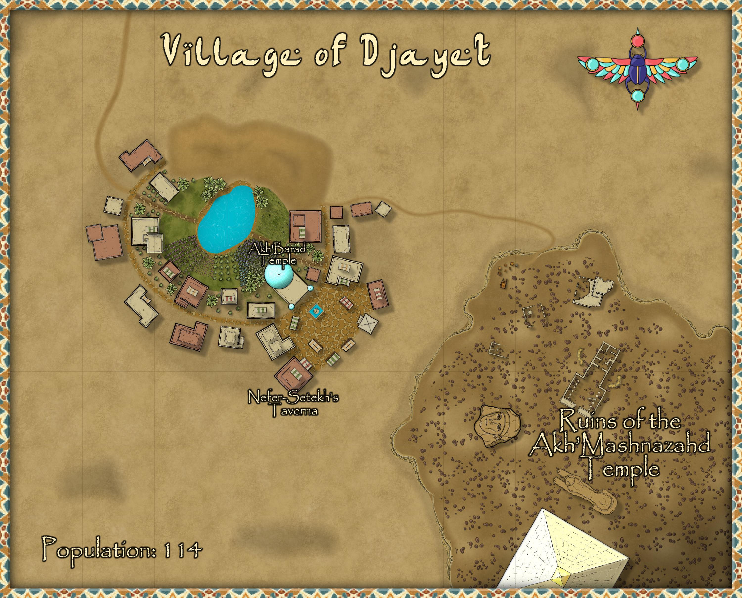
After my village of Per-Nezahd grew too large and is rightfully now a town, I went back to the drawing board and created a new village in the same Desert Oasis style. This one is significantly smaller.
[Note: this is in an area of the Atlas that has not yet been developed. I have parent maps almost ready to submit, and will start a thread later this weekend to submit them. Just finishing up the descriptions for them.]
There are 22 buildings that are either fully residential or mixed-use business/residential. I assumed an average population of 5.2 residents per residence, giving me a population of 114. Does that sound about right? I also spread things out a little more than you would in a walled city or town, but maybe I should spread things out even more?
I used varicolor bushes of different sizes to create crops. I don't know much about desert oases form, but I thought maybe a hill would be needed. I added a darker terrain below the hill to distinguish it from the smaller patches of hills scattered around, which were meant to be sand dunes.
I was going to use a ziggurat from SS5 as the temple, but the temple symbols in this annual were too irresistible to pass over. In the end, the only symbols I used outside of this annual were two broken columns in the ruins from CA49. For a village like this, it didn't seem necessary to label much in the village itself, just the temple and the taverna. I don't think a village of this size could support too much specialization, though there are market stalls available for the use of trade caravans that pass through. I also figured that this village was too small to afford to construct a wall (though maybe I should add a tower or two?).
In the lower right on a bit of an outcrop, I set some ruins of an ancient temple and city. Near the road that reaches the ruins, I placed a cart and scattered boxes and barrels to suggest that maybe an archeological dig is underway? Adventure hooks: maybe the archeologists have disturbed an ancient malevolence that should have remained untouched? Or maybe, Indiana Jones-style, the adventurers need to race to find an ancient artifact before the opposition finds it.
For the title, I used the default font for this annual, but it was too hard to read for other place names, so I used Papyrus for those labels. Is it okay to use a different font for the title? Should I switch the title to Papyrus? I didn't use the scale bar, as pretty as it is, because it says "miles" on it and this map is only 500 x 400 feet. (Although...if I ungroup it, maybe I can delete the "miles" text? I will have to try that.)
Any advice or feedback?


Comments
Made some tweaks. Got feedback that if the pyramid may be an adventure hook that someone may want to map, maybe it shouldn't get cropped off the screen. Moved a few things around on the outcrop so that it could fit on screen. Also added the scale bar. Figured out that to edit the text from "miles" to "feet," I had to explode it first, then ungroup it to edit the text. But now I have this nagging memory that we aren't supposed to include scale bars in the Atlas?
Any other feedback or thoughts?
Scalebars are fine in the Atlas.
You can change the font in any symbols like this in your map by making a new symbol with your preferred font in.
Select the symbol in Symbol Manager (in the Symbols drop-down menu), and Clone it, giving it a new name (this is very important, so you don't overwrite the original symbol).
Then, still in Symbol Manager, select your cloned symbol and click to Edit it. Draw your editing pane and then make whatever changes you wish - all the usual CC3+ tools are available to work on the symbol.
Once you're happy with the new version, click the cross box in the top right corner of the editing pane to dismiss it, and you'll get a terrifying message like this:
Despite the terror, click "Yes" - it's fine to do so with the cloned image.
Then your revised scalebar will be available to use in that map only.
Just saw your note, @Wyvern. Question: if I clone a symbol to modify it, can the modified version still be used in the Atlas?
Added two watch towers, one on the northern road and the other on the south side of the village. Moved the towers, the sphinx, and the temple to a new "Symbols Very High" sheet with longer shadows sufficient to show they are taller than the trees. Moved the pyramid to a new "Symbols Highest" to show it's the tallest thing around.
Any thoughts about the title font being different than the label fonts?
Question: if I clone a symbol to modify it, can the modified version still be used in the Atlas?
So far as I'm aware, yes. I've done it before certainly.
Wyvern is correct here. Basically, anything you can do with a symbol inside CC3+ is completely fine.
You're only running into problems with the atlas if you are doing anything to the actual .png files on disk, which includes copying, moving, renaming or modifying them. Also, if you import images as symbols into your map using the Import pngs command, you can only import images from atlas-legal sources in their original location, and make very sure NOT to check the "create other resolutions" or "copy to folder" options while doing so.