

[WIP] Community Atlas: Snakeden Swamp, Lizard Isle, Alarius - Dedicated to JimP
 Wyvern
🖼️ 287 images Cartographer
Wyvern
🖼️ 287 images Cartographer
Following the recent death of our long-standing regular Forum contributor, and most active Community Atlas mapper, Jim Pierce (JimP), I felt it would be appropriate to bring forward this small group of maps from my sort-of Dungeon24 project for the Atlas (now of course Dungeon25), and dedicate them to Jim's memory. They were already being planned while I was preparing those recently completed for the Demosthenes Swamp region in Artemisia, as while drawing the Seer's Hall Village map, I decided to use as its base the design from the Inkwell Ideas Dungeonmorph Dice "Cities" dice-face 6R, even though the "Ruins" dice-face 6R* version of that design was already intended for Lizard Isle, off southern Alarius. Working on the intact version set me wondering about the ruined one too, and ideas started to coalesce for that as well. Ordinarily, the 6R* map would have followed only much later in this project otherwise.
When I looked at the Lizard Isle map in the Atlas, I discovered it had been mapped by Remy Monsen for the second anniversary of the Atlas using the original CC2 mapping style, and the variant CC2 fantasy overland style from Symbol Set 1. That decided me to also construct this small set using similar "early CC" mapping styles, as something I'd not attempted before. The reason this linked with JimP in my mind was because such early styles reflect Jim's longevity as a CC mapper - longer than those still active as mappers with the program can now recall - and his longevity with role-playing games going back to the very earliest days, which latter was similar to my own. In addition, Jim was often keen to go with "no frills" mapping styles to sketch his ideas quickly, which again is reflected in the relative simplicity of such early drawing modes.
Further to that, although I'd already derived lists of items I wanted to include on the maps and in their descriptions, and decided where things were to go at least loosely, I'd not begun any CC mapping, so this topic is going to be something of a work-in-progress effort, something else Jim was noted for on the Forum, albeit I cannot match either his speed in mapping, nor his regularity of posts here. So as with this being a sort-of Dungeon25 project, this is a sort-of WIP topic!
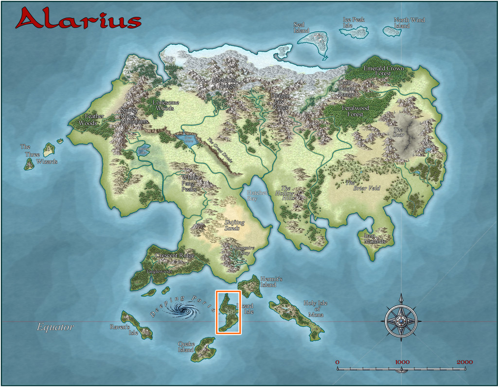
This is where Lizard Isle is:
And this is how it was mapped, along with the location I chose for these maps, the small orange square in the north-central area of both versions. "Small" is relative at this mapping scale, however, as that square is really 20 miles per side. The fancier SS1 map is shown in the second image below:
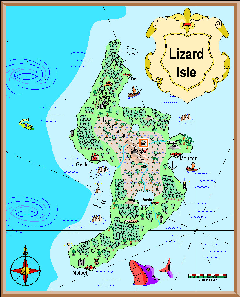
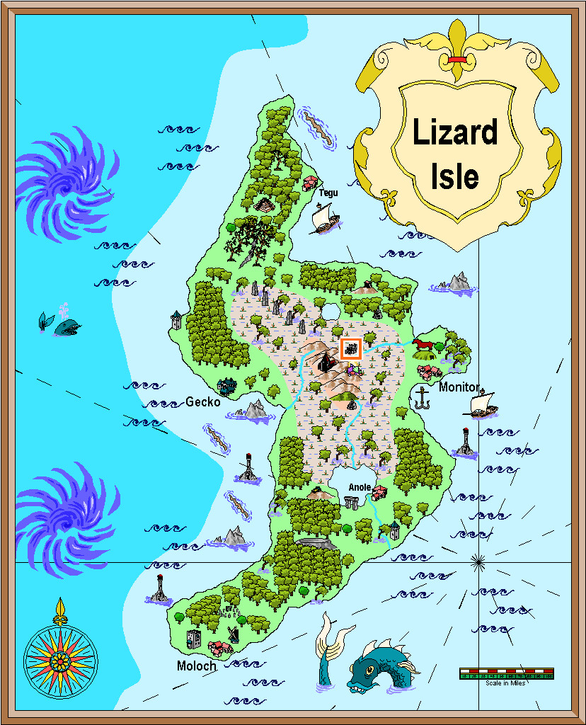
It may not be obvious at this resolution, but my chosen feature is a ruin symbol, as might be expected, given the base map I'm working with is also a ruin. The first shows a large ruin (there's also a small ruin in the style), while the SS1 map has a ruined town symbol (and there are ruins available in the style from city down to hamlet, castle, keep and tower in size), so that helped establish better what would be appropriate here.


Comments
With the location selected, I extracted details from both map versions, as shown by the following pair of images covering just that 20-mile area, now gridded-up into number-labelled one-mile squares. The red dots indicate which were to be randomly allocated some new feature or other. The red star is where the main 6R* map will be going eventually, more or less in the centre of the ruin symbol (as in my previous post, the SS1 map is again the lower of the pair):
I prepared these two versions, as it wasn't always clear when zoomed-in this far where some of the pre-mapped features were, aside from the variation in shape and size of the ruin symbols in each. Much of the area is covered with swamplands, and as the location is at roughly 7°N latitude (the equator line is shown on both versions of the full island map), that means equatorial-tropical conditions. There are though hills to the southwest, and a major river to the southeast, plus of course that "huge" ruin.
From early on, I felt Lizardfolk would be the suitable main humanoids here, largely from the island's name and location, coupled with what some of the random-feature rolls had indicated. I was using a combination of items determined from tables in "Dread Thingonomicon" and "Dread Laironomicon" by Raging Swan Press, as also for the recent Artemisia maps, and some from Atelier Clandestin's "Sandbox Generator" and supplements, that I've used from time to time in this project before. Plus I'd also been thinking a lot about Lizardfolk more generally because of the set of Artemisia swampland maps, as they were the dominant humanoids there.
Oversized symbols are a fact of life with many fantasy mapping styles. There's often a general assumption that the actual feature illustrated will be located around the mid-point of that object on the map, and not be of the same apparent scale-size as shown by the map. Even so, it can be interesting to think beyond this sometimes. I did that with the weirdly gigantic barrows in Feralwood Forest elsewhere in Alarius earlier in this project, for instance. Here, the fact both symbols chosen for the ruins were town-sized, and not something smaller, set me thinking that scattered over a roughly 20-mile-square area, this might once have been the site of a city-state-sized realm, and so maybe there'd be other ruins besides the main "central" one I'd be mapping later, in other parts of the area occupied by the original symbol. Random-feature table options were then selected appropriately for that idea, as I came to think it would be interesting if outsiders might get the mistaken impression this had once been a gigantic settlement of some kind. The surrounding swamplands create an ideal means to mask that former reality here, if it was, of course.
With the preliminaries sorted, it was time to start mapping - next time!
That's awesome. So kind of you to dedicate it to his memory.
Just a thought - how about also mapping in one of the areas already done by Jim, mainly on the island in the Forlorn Archipelago. He did quite a lot of regional maps there, especially on Fisher Island. And perhaps it might be a nice community effore to have others map in regional maps done by Jim. Just a thought.
It's great to see work being done to expand on Jim's gifts to us.
Thanks very much folks.
Ideas and concepts for this little map group just seemed to fall into place around the time of Jim's death, and Jim's insatiable mapping efforts and enthusiasm, both for the Atlas and his other numerous projects, had already helped maintain my own focus on the Atlas mapping I'd embarked on, albeit at a far slower rate than Jim's. So it all started to seem as if it was somehow intended.
As I'd already mapped something for Kraken Island in Jim's Forlorn Archipelago last year (Haunted Cloud Mesa), and as the locations for all these D24/D25 maps were decided a year ago, I didn't want to switch sites for this one, as I've set things up to only place one map (or map group, where there's an area map as well as the dungeon one) per regional area selected.
Ricko's already suggested an additional map of his own for another spot on Lizard Isle, and will post that here shortly, I think.
With permission, I add JimQuetzal's Pyramids to the map.
The Legend of the Pyramid of the Sun of Jimquetzal
Deep in the sweltering jungle, where trees stand like ancient sentinels and sunlight barely touches the ground, lies the legendary Pyramid of the Sun of Jimquetzal. Over the centuries, the jungle, like a patient beast, has reclaimed what was once its own. Lianas twine around the black stones of the pyramid, while colossal roots crack the ancient steps. Its blocks of black stone, covered in moss and grotesque roots, emerge like the teeth of a sleeping colossus, a scar on the earth forgotten by time.
Legends whisper that the pyramid of Jimquetzal was the throne of a long-lost sun god, whose name has dissolved like dust in the wind. It is said that the ancients who lived there did not build the pyramid, but dug it up, guided by feverish visions that drove them mad.
Other stories tell of the Faceless Guardian, a figure shaped by eternity, half man, half beast. He patrols the steps of the pyramid, protecting the secret of a hidden relic: the Eye of the Sun, a gem of living gold that, according to the elders, is the source of divine power. Anyone who dares to touch it is instantly consumed, their body transformed into ash that the wind carries away to feed the hungry jungle.
I used Google Translate, I apologize for any mistakes.
Cheers
So, back for an update today!
Opening the New Drawing Wizard, and naturally picking the CCPro Overland style, I set-up a 30 by 30 mile square area (to give room around the base 20-mile-square mapped region for a title, possibly some labels, and suchlike), and changed the background colour from its default sea-blue to green, to fit the landlocked swamp I had in mind. Then I went to set-up a new BITMAP sheet and layer to import the base map image into, and was surprised to find there was more than just a single sheet available (which was what I'd expected), and that some of those sheets already had effects on them. I'd been assuming I'd be working without sheet effects (beyond a transparency on the BITMAP sheet, at least). This though opened up some fresh possibilities, as one concern I'd had was that a lot of the early vector symbols and fills use zero-width lines, which tend to vanish when extracting higher-res images. Being able to add elements like glows could help them stand out better, so this was going to be a somewhat more sophisticated map than I'd anticipated!
This is the opening scene with just the imported bitmap image in the map (I'm keeping these opening images deliberately under-sized for the Forum, as there's fairly little detail on them):
And this is it with the transparency effect on:
Next, I started sketching-in some base terrain elements beyond the centrally-mapped area, using only symbols, to have more control over their sizes. Here, I'm working with the BITMAP sheet's transparency turned off:
This is the appearance without the bitmap image entirely:
One advantage of this vector mapping style is that you can add effects such as transparency to the symbols sheets, and see - as here - that the symbols fade out a little, which is what I wanted to do for the area beyond the mapped zone, showing the terrain there still, yet without so much detail. There's no need for technicalities like the forced redraw command that would be needed for raster symbols, though these were all set-up on their own new sheet, of course. The symbols, incidentally, were all from the extensive "Filled" vector set available under the CC3+ overland style, which was the default set available on opening the new map.
The next snapshot shows this whole border zone completed, with the hills and river added, as well as a background colour showing the full extent of the hills into the central region as well:
I amended the edge fade on the terrain sheet to retain the softer transition at the edge of the hilly area. The perceptive may notice too that one hill seems a little less transparent than the others, as that one's now on the main symbols sheet, that has no transparency effect on it. That difference is a little more obvious as the central area gradually fills-in fully:
With that completed, deciding what symbols would be suitable to highlight the features on the fully-mapped area could begin - next time!
Next bit!
I'd already had to adjust the symbol sizes to be sufficiently visible on the map for the base design, as the default setting had proven much too small and hard to see. When I started adding the feature elements, those felt still a little too small even using that adjustment:
So I tried this higher-res test - this and the subsequent images are all at the standard, larger, Forum size-resolution, here concentrating on just that key central map portion:
The new symbols indeed look awfully small here as well, so were quickly changed to larger sizes, although that in turn meant some further adjustments in positioning to retain clarity, and sometimes even swapping-out the symbols for alternatives, a process that was likely to continue for the rest of the mapping (which I find to be a very common occurrence). The central area with resized symbols:
Followed by a shot of the whole-map view:
At about this stage, although it seems I didn't preserve any of the screenshots I took during it, I tried adding some of the Character Artist vector monster symbols, to show what creatures might be found where in some of these locations. While that seemed worth an experiment, as the general drawing style is comparable with the other symbols in the Filled set, there's a little too much detail on the CA creature drawings to work at a suitably rescaled size here, so ultimately that idea was dropped, which is probably why I overwrote the images showing the attempt. Hey ho!
Finally for today, we have the map with all the inner-zone features added, albeit these are still little more than place-markers at this stage, before a range of adjustments takes place to settle them in better with one another, and so that aspects such as the stream-lines make better sense with those in the larger region, etc.
Edging a bit closer to a finished map, at least!
Sometimes, the Forum throws weird notices at you while you're doing other things. That can be because you've been sent a new message by someone, or somebody's just posted in one of your topics, or someone's added a new post to the topic you were typing your notes into, for instance. Here, I just posted the above, and suddenly it announced I had achieved the rank of "Cartographer".
Now, these labels are just for a bit of fun on the Forum here, of course. However, it seemed very apt that this should have happened by chance while I was adding to this topic, because our departed dear friend JimP was also of that rank. It just made stop, think and remember again for a moment. Which was also part of the purpose in my doing these maps in the way I am.
Congratulations :D
Thanks Sue! It caught me quite by surprise!
Congratulations, Wyvern -- and indeed, very apt to come when you're designing a map in Jim's memory. I've been pondering ideas for something to do in his memory, too. Maybe a temple or shrine dedicated to "Saint Jimpey, patron saint of navigators."
Nice idea, @Royal Scribe - maybe you could do something using one of the isometric dungeon styles from the Annuals, if you have any, as they were one of the styles Jim did a number of maps and experiments with. I thought about those as well for this map set's subterranean maps, but the Inkwell dice designs I'm using as a base are all purely top-down views, and I want to stick with that for now.
Yes, I was thinking about an isometric dungeon since that's what I remember best of his work. (I now have Perspectives, Symbol Sets 1 through 6, and all of the annuals except 1, 3, and 6, so I should have some isometric options available.) My other thought was something that looked very old-school early D&D, like CA97 OSR Dungeons, to reflect his long experience as a cartographer. But isometric is what I most remember him for, and it's a bit out of my comfort zone and therefore a worthy challenge.
That adjustment process mentioned previously ended-up spread over several days, as time wasn't available to try to do everything together otherwise. Thus there's just the one version showing the end product of all that, after some further vegetation and streams had been added. I did at least manage to slip in a couple of streams that simply vanish into the swamps though, instead of continuing off-map, which is something I wanted to do from quite early on.
I'd thought initially that simply the faded outer ring of basic terrain would be sufficient to indicate the fully-mapped central zone. As the mapping proceeded though, it grew more obvious that that wasn't enough, so I'd started thinking of alternatives from quite an early stage, without settling on anything definite (hence the continued absence of anything like this so far). Now, I felt what was needed was a new frame of some kind, yet one which wouldn't have the hard cut-off of the traditional map border, because it was going to go inside the whole map, surrounding that middle square.
What I chose was a heavily rescaled version of one of the bamboo symbols, with separate X and Y axis adjustments, placed as if done quite casually. That though also made the original outer frame redundant, so it was swapped out for a simpler coloured line instead to give this:
The bamboo poles were placed on the CARTOUCHES sheet, which already had a helpful Drop Shadow effect on it, which with a suitable adjustment, is what we see here. When I began adding labels to the final map version though, I found this new bamboo frame - which already looks a little too awkwardly small and close to the feature markers in places - needed a further slight enlargement. After that a few further changes were needed on the map, to help get a better placement for the labels, and also to correct a few errors in the symbols when checking again with my descriptive notes. Plus some extra embellishments were added to complete the map - as I just couldn't get away without adding a couple of those CA monster symbols after all!
Eventually, there will be text and PDF files on all this for the Atlas version, once I've fully deciphered my hand-scrawled notes, as there are still more maps to prepare in this area, as we zoom-in to Snakeden Hollow and those ruins that started it all...
The surface map for Snakeden Hollow presented an unusual challenge, as there is no equivalent to the old CC2 style for city-type maps available with CC3+. Source Maps Cities - City Map is perhaps the closest we get, although the symbol options for that alone are rather limited, and don't have options to easily show, or create, ruins, which I'd need for what this map's to illustrate. Instead, I opted for the CD3 Vector Shaded style, using the Vector Classic symbols. These provide a very large range of options in a clean, simple, drawn look; in fact if anything, it's difficult to hold in mind exactly what's where among the series of extensive symbol catalogues in this style. There are five different sets of options just for trees, for example, each in a separate catalogue (there is a sixth, but I think that's a duplicate). As this wasn't a style I've done anything with before, I spent some time - the equivalent of a full mapping session - simply exploring the range of symbols available, and also the drawing tools, to get a better feel for what was available.
In the meantime, I'd also sketched out a general layout for the ruined settlement. The Inkwell dice design was to form one tiny segment of that whole, as I was influenced by the symbol from the Lizard Isle map that showed there to be a substantial ruin here. You can get an impression of the Inkwell design's appearance and original size from the Seer's Hall Village map in Ezrute (as this is the intact version of the Snakeden ruin die-face), discussed on the Forum here earlier. However, during the planning process for this map, I decided it might be better to double its size in this case, partly to stop it from being lost here, partly to make the surviving buildings a bit larger and more imposing. The Inkwell dice designs aren't specifically scaled, although there is a basic assumption that the subterranean ones will be scaled to around 100 feet per side.
That settlement sketch-plan was determined initially using the standard Shadowdark RPG's system for randomly generating settlements, as far as its layout and some additional major structures were concerned, with more additions from the old Judges Guild ruins system, presented almost 50 years ago now (groan...) in their first "Wilderlands" products, all tweaked appropriately. This led to the sketch-map becoming so cluttered and confused that even I'm not sure what all the scribbles mean now, thus I've avoided showing it on any of the following WIP images! I have though left the little Ruins dice sketch design on the first two screenshots, to help give a degree of orientation and scaling.
As with the area map, on creating the new CC3+ file, I found there were several sheets with effects already on them, so again this was going to be a more relatively sophisticated map than I'd earlier anticipated. The shots that follow are also of a reduced size, as previously, as they're really little more than impressions of progress at this stage. This one's with the base terrain colours and main streams sketched-in:
For a bit better clarity, I've turned off the transparency effect on the bitmap sheet with the dice-design sketch. The yellow-green towards the edges is the general swamp terrain, the darker green where the jungle-woods are going, and the "other" green is the basic background.
Next came the road-lines:
Again, these are simply to indicate the general layout at this point, and their relative widths. These were soon to be altered, as the widths were simplified here to get the lines drawn quickly.
Next, some contours were added to help suggest the "Hollow" aspect from the place-name - hence why those swampy patches were drawn as they were too - and the first elements from the Inkwell dice-face were added as well:
There are no suitable escarpment symbols available to fit what was needed here for the cliff-face, so I simply dropped one into the map at an appropriate scale size nearby, and drew a set of suitably-spaced and sized lines for the cliff-face as sketched, and then discarded the symbol.
Moving on, the rest of that small square segment was completed, a process that included finding and testing various of the rubble, ruins and similar options spread among several symbol catalogues. The perceptive may notice too an experiment in adding a second height contour to some of the hills. Ultimately, that was dropped as showing nothing useful, once more symbols and elements were filled-in elsewhere. It does feature on the next couple of images before that decision was made though.
There is a reason too why the ruins are chiefly on the southern side of that little square area, which will only be revealed later!
Various fresh symbol elements were added at this stage, including where the main Lizardfolk groups are situated across the settlement (hut clusters), a few more ruins and still-standing buildings, some of which were from the main new features randomly added during preparation, and the start of the vegetation symbols.
Of course, at this point, nothing is too firmly-fixed, but I was liking how the trees worked with the whole. Wasn't so sure about leaving the base vegetation colouring behind the trees at this point, although this was the stage I realised the higher contour colours just weren't working with the tree cover.
So this is where I'm up to currently, with all the trees set-up across the woody areas (there will be more elsewhere in time, though less densely), the higher contours gone, and decisions to be made next as to how best to show the swamp vegetation. More to follow...
Clearly, something was needed to add further character to the swamps, and the first thing was slotting-in some lakes, ponds and smaller watercourses:
The new river lines were all kept deliberately the same size, and perhaps a little wider than necessary, to try to ensure they'd still be sufficiently visible after adding the vegetation. That latter was to be a mixture of mostly lower (lesser shadow), smaller, patches of greenery, including little-shadowed palm tree symbols to represent stands of swamp reeds, with a scatter of taller, = longer-shadowed, trees. This next shot shows the opening trial of this in the central hollow, although the sharp-eyed may also spot a couple of fresh structures have appeared in the northeastern woods as well, as I'd missed a couple of still-standing places there earlier, hidden among the chaos of my hand-scrawled base map:
Another two screenshots help indicate the general "vegetising" process over the top left swampy region, the first image with just the flattened-palm-tree "reeds", and the second with the remaining bushes and trees:
Two more images illustrate how the remaining regions were similarly filled-in, and how some vegetation scatter was added to the stream-lines linking between the edges of the swamps and woodlands:
I've left the swampland vegetation somewhat sparser on the right side of the map to give some space for possible other features to be added, as I hadn't firmly decided if some of the roads and tracks might be continued into it at this stage, or exactly what structures might be near those there already. Plus I also wanted to add some more stream lines at some stage later on (still haven't done those).
Here we see the first segment of "new" ruins being added, around the originating dice-map segment in the lower centre-left:
It was at about this point I realised it was growing harder to define the road lines, and where the hill contours were, a problem that worsened when the vegetation scatter began to be added around those previously clearer areas. Thus a lengthy spell of experimentation, changing the effects and colouring involved, followed. That in turn needed more features adding elsewhere, using the central section adjoining that already completed, just to make sure everything still worked OK. The results of all that:
Which only brought up a further issue, as it's obvious that the reduced-resolution images are all looking rather too dark and messy now, especially over those ruined structures. So more experimentation followed with higher-res images and some antialiasing, to get to this degree of clarity (same image as above):
Following all of which, there wasn't much time to do more than a few further additions ahead of today's postings, which is where things are currently:
Not too far from completion now, at least, albeit still with the labelling to begin, not to mention those extra streams!
Pretty awesome I like the vibe of the map.
I even don't mind the first ones, give me the Forgotten Realms Interactive Atlas feel.
The final stages of mapping took a bit longer than expected, as that top area, still incomplete last time, had been allocated more ruins and features than many other spots. Along with this, the additional minor stream channels were emplaced in the swamp too, with a few more shrubs and trees in places:
I'd always intended to replace the map border with something more rustic, like that for the Snakeden Swamp map earlier, and settled on the angled fence-line symbols from the options available in the CD3 Vector Shaded style. They also look like sharp teeth a little, a happy accident. Getting these to look right took quite a degree of trial and error though, and while the corners don't perfectly match on this final version, I was happy with that, because I didn't really want the frame to look too perfect anyway - Lizardfolk fences, after all!
After which it was time to start thinking of labelling the map, adding a north pointer and a scale. Unfortunately, there aren't options for the latter two in this style, so alternatives from what symbols were available had to be drafted-in, again with some experimentation, and tweaking of effects:
At this point, the pale brown lettering seemed fine. However, when some place-name labels started being added across the map, it rapidly became clear that both this colouring and the black shadow and glows were interfering with the effects on the mapped symbols, creating irritating bleed-through lines on parts of the text. More experiments followed to adjust both to something that was still sufficiently clear, yet which wasn't equally causing such problems. Which turned out to be this:
With this map finished, it's now time to head underground, since although the little square surface map with the cliff-line (the area now labelled as "Undercroft") was the original dice design that prompted these maps, it was obvious to me from the outset that the two cave entrances in the cliff would demand more attention - as to be shown next time, if all goes to plan!
Having decided to add an underground map for the Snakeden Hollow one, showing to where those two cliff entrances lead, an extra floorplan was needed from the Inkwell dice designs to accommodate it. I opted for a caves-only layout, and because I already had in mind what the main critter was going to be in there, it needed to be a sufficiently large and interesting layout too. The size and shape of Temple Hill had already indicated a two-dice pattern was going to be more likely, so I dug through the options available for cavern layouts that hadn't been used already, or weren't already planned, and rolled a few dice, before finally selecting one die-face each from the "Lairs" and "Spellunker" dice sets.
That pattern was sketched onto graph-paper as usual, and then scanned-in ready to be redrawn in CC3+. This first image (reduced-size at this point, as typical from the above) shows the basic wall lines over that hand-drawn scan, done using the DD Pro Dungeon style (which, much as the other "early" styles used in this map-group, turned out to have more sheets and effects present than originally expected).
As this indicates, there are going to be various internal levels within this single layout, which promises an increasing degree of complexity in the map-drawing. I feel an attack of the sheets (and more effects) could be imminent!
There are obvious elements in need of adjusting already. Both entrances have solid wall lines across them, for instance. Plus of course, as anyone who's used this drawing style may realise, the wall lines don't just draw themselves, as they're half of the basic caves drawing tool with the floors (hidden here for clarity of the scanned JPG). Oh and that word in the lower right corner actually says "Well", as that's what that circle-and-dot symbol nearby represents. I couldn't read it either, when it came to it...
As the perceptive may appreciate from this, some CC3+ magic has already been applied here, laying down Color Key polygons for the internal solid-rock elements, by copying the relevant wall lines to the Floors sheet, and converting them to filled polys of suitable colour. The same map without the bitmap and with the floors:
and then with the effects turned off:
Next task was to break the wall lines for the two entrances, and then add a series of masks to hide the unwanted segments of wall shadow in the solid rock. Not sure the shadows will remain ultimately. However, the masks help clean-up the overall look somewhat:
Well, actually a bit too much, as the wall lines are now almost invisible. I could just have thickened up the lines, although that starts to encroach into the available space in the caves, so instead, I just copied the wall lines onto a new sheet above the mask with no effects on, and thickened those up a little instead:
As is probably obvious, the map layout has been deliberately off-centred to allow a sliver of the exterior to be added along the right-hand edge, hence why the wall shadows at that end haven't been fully masked yet. When I dropped-in the exterior JPG scan though, it was immediately obvious that both tunnels needed extending further, to better allow the cliff line's curvature to fit to the interior design, so that was the next step:
That proved more problematic than expected, as for reasons I never got the bottom of, while extending the floor was simple enough using the "Edit" function for the cave drawing tool, as was editing three of the four wall lines with a suitable new drawing tool, the uppermost little new wall section would not connect to the rest of itself after completing the edit process. The line drew just fine there, but as a separate entity, something I only discovered when copying the lines to the above-mask sheet. I tried redrawing it, with no better success, and as it looks OK, decided to just leave well enough alone!
It did though take rather more time than expected to get to this stage, so that's where we'll have to leave it for today.
Looks good, can't wait to see how it ends up. Thanks for sharing the process.
Well, actually a bit too much, as the wall lines are now almost invisible. I could just have thickened up the lines, although that starts to encroach into the available space in the caves, so instead, I just copied the wall lines onto a new sheet above the mask with no effects on, and thickened those up a little instead:
This is a clever approach and it looks very nice. I always learn so much when cartographers share their tricks and techniques. Thank you!
Thanks very much folks!
Much of the process is just remembering all the things CC3+ can do for you, and then applying those when (if...) you recall them in time. I'm not sure if this applies to others, but having spent many years hand-drawing maps in various formats does seem to help in understanding better what might be tried to change up the appearance of what I'm doing in CC. If not always 😁...
Resuming where we left off, the next phase was to add the external segment at the map's right side. Rather than redraw that, I simply copied and pasted what was required from the Snakeden Hollow map, added, and in some cases amended, the relevant sheet effects to better fit this different map-view scaling, and adjusted the cliff to be a simple line, separating interior from exterior.
The vegetation looks a bit sparse there now, so that may need adjusting too later on. I also had to add an extra mask segment to hide the wall shadow from the new cliff line near the top, where it was showing on the interior of the rock. Other tweaks seemed likely as well, but I wanted to get on with the complexities of the internal layout, so switched to that.
Which brings us to something of a hiatus in screenshots, because this process turned out to be a lot more complex than expected. Looks great as a simple hand-sketched view - five minutes to draw that... Yeah, right! Basically, it turned into two full sessions spread across a couple of days, with a lot of switching and changing, during which I completely forgot I was meant to be recording such things as I went along.
So, imagine a burst of gentle harp-music, water-on-glass visuals, as we fade back to where this got me finally:
Main obvious change, aside from the range of new features, is that the interior floor colouring has been darkened. At the same time, much of the internal wall shadows have been reduced significantly, while still helping to differentiate the various levels in a more subtle way than the original shadows. In practical terms though, the whole interior floor has been redrawn as separate pieces, because it proved impossible to retain the complete original floor even for the lower part (darker, extensive, left-hand segment, except the darkest cave's floor there). That was largely because of the glows on each floor element, and the stair symbols, interfering with one another. Several now have separator sheets and underlying mask polygons added, to further help keep things clean.
At which point, I remembered I should have been taking more screenshots, so here's one where the changes are so subtle you may be hard-pressed to spot them:
The well's been added as a first test for how the internal lower symbols would look (lower right, on yet another new sheet) and the basal shadows for the two sets of stairs in the darker leftward part of the drawing have gone. Well, masked now, at least, to look less steep-drop-floaty!
It was about this point I stood-back and examined the map as a whole for once, always useful in the latter stages, to see how things are working together as a complete map, not just how individual bits are holding up when zoomed-right in to fine-tune things. Which made me realise I was struggling to differentiate between the separate internal solid wall blocks and the floor levels. Thus with a few clicks, the interior rock colouring was changed to:
Some further amendments have been made as well. The tunnel through the raised floor in the large right-side cavern has been added (no, it hadn't been forgotten, although earlier I had forgotten the steps up on the south side of that extended raised platform, leading to the rounded cavern at its end, during the unrecorded mapping sessions). The other changes are likely too subtle to be spotted, adding masking patches to tone-down the upper-level shadowing glow by the three small drop-lines at the cave-mouths in the left-hand section. I tested a similar idea on the longer ledges as well, but felt those looked better without them in the end - as they are here. That mild shadowing suggests a slight dip towards the drop-line that seems to help fool the eye better.
With that all completed, it was time to start adding some symbols to give a little more life to the whole, as well as a scaling grid for the interior (I decided against adding one for the outside too, as this is really a map of the interior, after all). A couple of sloping-passage arrows were added along the way:
The wall shadows mask had to be extended to hide unwanted bits of the grid, although because the original mask followed the complexities of the fractal cave wall, that proved unworkably slow and impossible to control by the normal node-editing processes, so fresh patches of suitably-coloured polygons were dropped-in instead. After which (higher-res map now - must be approaching the end!) it was time to break-out the labels, north pointer, etc.:
Plus a decorative SS2 Lizardman. And sans grid:
On the CC3+ version, these labels all looked fine and clear. As soon as these JPG test versions were done, it was obvious the labels weren't working nearly so nicely. I also didn't like the faintness of the scale square here. So more changes followed to reach these final versions (unless I decide otherwise before submission to the Atlas, anyway!), with and without the grid:
A trio of external labels were added in the process too.
Now I need to make some progress getting the notes for all three of these typed-up and finalised so they can head-off to further swell Remy's queue of maps for the Atlas!
I'll post again when that's done.
Oh, and the critter in the Undercroft. It's a huge, serpent-bodied, 20-headed hydra!
I loved the retro feel and the colors match really well.
Thanks very much! The styles to do this trio of maps are really pleasant to work with in general, and are nicely straightforward, with clean lines. I also like the simpler vector styles because if you need to draw your own symbols or features, it's not that hard to do. The bitmap symbol styles require Genuine Artistic Ability too often; general lack of which is how I came to prefer mapping on computer in the first place!
So finally, these maps have now been sent of to Remy for inclusion in the Atlas. Nothing much to add to what was last mentioned here about them, although for those interested, the three PDF files of notes for the set are here:
And I forgot to mention that next time's mapping is to be for a location in Statrippe, Artemisia, where I've already found a curious small island just offshore with a ruined castle...
These maps are now integrated into the atlas. Thanks @Wyvern and @Ricko