

[WIP] Community Atlas - Rhaghiant (western Doriant)
 Royal Scribe
🖼️ 388 images Mapmaker
Royal Scribe
🖼️ 388 images Mapmaker
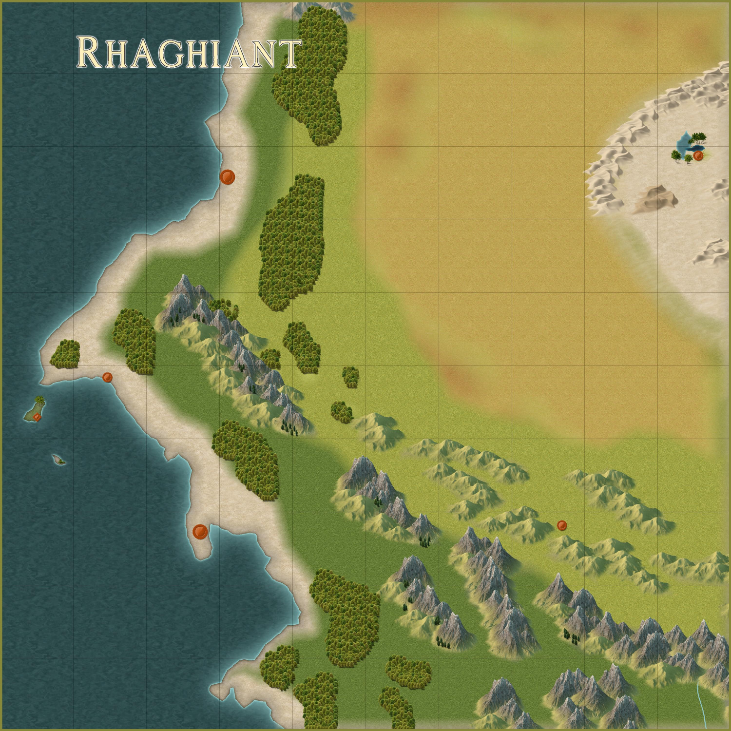
Okay, here's a first pass at the portion of the map I've adopted for the Community Atlas. This was done using the Spectrum Overland style. So far, this is mostly just terrain converted from the parent map.
I want to add more individual trees around the edges of the forests where they look too squared off. I still need to add rivers (this map only came with one in the bottom right), and if necessary, more hills or small mountains at the source of the rivers.
This map came with five settlements. At this scale (each grid square is 100 miles), should I keep the beveled dots from the parent map or use the lovely Spectrum Overland symbols? I created a diamond-shaped one (on the larger island) for other points of interest. (I'm thinking that island may be a resort playground for the rich and famous, like a cross between Monte Carlo and Las Vegas, that operates outside of the reach of the country's law enforcement.)
I wasn't thrilled with how the savannah/grasslands blur into the desert on the right. I may need to adjust the sheet effects. I also thought about encircling the desert with dunes. I did it half of it that way so you can see it with and without the dunes. Thoughts? Oh, and I need to add some saguaro cacti or joshua trees.
I'd like to add a swamp somewhere. I plan to add a henge at one of the northern forests, surrounded by more trees -- that's where elves live. And a dwarven fortress in one of the southern mountains.
Roads will come last, once I've determined the rivers, major settlements, and points of interest, and then need to connect them.
Advice welcome, including the name.


Comments
Here's how it's progressed so far today. (Still not wed to the name.) Still need to do more in the middle area that I am mentally calling the Midwest, even if it's just adding some hills with tiny rivers coming out of them. Trying to figure out where to place my existing maps and the future ones I'm planning.
I redid the two northern forests to add rivers, a road, and a few smaller settlements...and a henge of stones. That northernmost forest will be an elven community that is outside of the kingdom. (This style doesn't have a political borders tool, does it? I may have to create one, or just rely on labeling.) There's a tepui at the northern edge of the second forest. I haven't decided what will go on top of it. Maybe a castle? Maybe a temple with an oracle, like the Oracle of Delphi?
Here's a closer look at the desert. You can see where I plan to place my ziggurat. The obelisk to the south is apparently all that remains of an ancient temple that was long-ago swallowed up by the sands.
Added some cliffs near the coast. The whirlpool on the western side is about where my Octopus' Garden will go. The upper island, as I said before, will be a playground for the rich and famous, like a Monte Carlo.
And I made a little swampy river delta with a settlement akin to New Orleans that I envision being rife with smugglers and ne'er-do-wells.
In the southern mountains, which is outside of the kingdom's borders, there's a dwarven fortress. You can't see it, but you can see the pair of towers (towards the southeast corner of the map) that guard the mountain pass leading up to the fortress.
Let me know if you have thoughts, feedback, or ideas for more adventure hooks to add.
Use the symbols, rather than the dots, IMO.
You're right, the symbols are better. I scaled the settlements down to 0.25 scale because at full size, they felt cartoonishly overlarge, even though they're meant to be a symbolic representation and not to scale. For example, I put a full scale city off to the side (in the ocean) for comparison. It takes up 75 miles!
Here's the full map, though admittedly the settlement symbols are harder to see scaled down here. Do you think scaling them to half size instead of quarter size would be better?
I won't show zooms of every area until it's ready for final inspection, but I did want to show off the desert.
The symbols here have inspired me to expand on the maps I was planning to do. The oasis city will be where my ziggurat will go, and the town midway down the river will be for the Ancient Cities map I did (which I will expand to cover the whole town and not just the northern edge). I decided to add another city at the western edge of the desert so that I have an excuse to design something with the Desert Oasis style from the 2023 annual.
When it comes to symbol sizes, I think an important part of a map is that information is legible when zoomed out. Exactly how large that is depends on the map obviously, but in most cases, it will mean the symbols will be covering more area than the settlement actually takes up.
Currently, the settlement symbols do look a bit small IMHO. They don't have to be scale 1, but I think they could probably be 0.5.
More "precision" is usually better done by making a new local map from parts of the main map, which can show more details, and "more correct" settlement scaling. Exactly where the cutoff point for detail level lies between those maps of course differ based on the map itself.
Thank you, that's helpful advice.
I guess Remy and I disagree on this matter, as I always tend to favour smaller symbol sizes than he does. But perhaps they could be increased in size from what they are there. I would increase their current size by about 50%, again IMHO
I tried at 50% of the original size (which is double the size I used). Does this work, or are the symbols still too small?
Am I correct in understanding that if I later want to work on a local map of this, say a 200 x 200 mile section, I can add smaller towns and streams to that? For example, I have a small town I did before that I'd like to find a home for, but it's only about a quarter of a mile wide, so I'm thinking it's too small to register on this scale.
Also, I should come up with names now for settlements shown here, and other major geographical features, rather than waiting to name them in more detailed local maps?
That looks a lot better. I can see that they are towns rather than something I can't interpret as being anything in particular.
Can you add smaller towns in the local maps? Yes. The whole point of doing local maps is to be able to add the details that aren't appropriate for the regional map.
I think that is about right.
I would name at least the major features, and since the settlements you have added are major, I would name them.
Just to confirm what others already said, yes, you can add additional details to local maps. That's the main idea, and the same thing you see in any printed atlas. The country maps only have the major details, but the regional and local maps have more details.
Obviously, the local maps shouldn't add features that are so large they should have been on the higher level map. For example, it would be weird to add a major river or a capital city if those weren't on the larger scale map, but adding smaller features, like settlements smaller/less important than those on the main map, smaller rivers, and so on is completely fine.
After all, if you don't add any detail to the local map, it hardly have a reason for existing at all.
As for naming, I think most features added to the map should be named. Names make it easier for those making lower-level maps to be consistent, and it makes a map into a map. After all, a map is for showing where things are, it is a map after all, not an aerial photo, and without names it gets kind of meaningless. Humans tend to name every feature around them, and my line of thinking is more along the line of "If it isn't worth naming, do it really belong on the map at all?". Some symbols may appear just for decoration and naturally don't get a name, but otherwise, most features should be named; settlements, rivers, oceans, forests, mountain/hill ranges, points of interest, major areas, etc.....
Detail maps will typically have more than enough new features to name.
That makes sense about making sure the major things are captured on the map, while being able to add smaller ones on the local area maps. And naming the features as well. I will have to come up with some names that aren't subconsciously lifting from literature. (Can't tell you how many times over the years I've thought, "Oh, Imladris is a good name for my elven kingdom -- no, wait!") I keep a running list on my phone of potential NPC character names. Some of those names may be suitable for place names instead (especially since so many place names are named after people.)
Here's the map as it stands with more hills in the "midwest" area, more rivers and settlements, roads and a few major bridges. (My thought is that except if I name where a road crossing a river something like "Blah Blah Blah Ford," there's a bridge there, but I added a few bridges that are meant to be unusually grand ones.)
Let me know if you spot anything weird or geographically improbable, or if there's anything missing. I also need to double check the Atlas maps to the north of the area I claimed to make sure there aren't features like hills or rivers that extend past the southern edges of those maps.
I renamed the regional map and therefore started a new thread for it: [WIP] Community Atlas - Gold Coast, Doriant. Just wanted to post a link here so that anyone stumbling on this post can find the rest of the conversation over there.