

[WIP] Community Atlas - Gold Coast, Doriant
 Royal Scribe
🖼️ 388 images Mapmaker
Royal Scribe
🖼️ 388 images Mapmaker
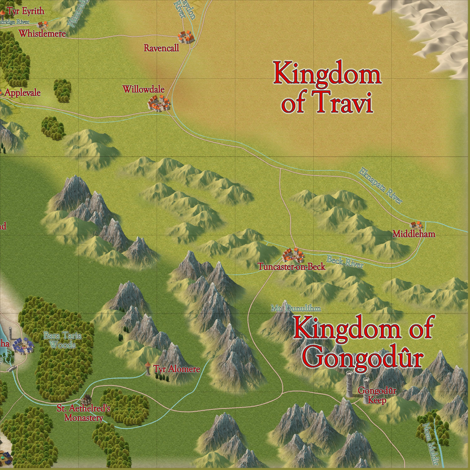
I've been working on a 1000 x 1000 mile part of western Doriant that I adopted. (This is separate from the elvish town in Verinress Arl, Artemisia, that I adopted for the 1000th map contest.) I know that new maps for the Atlas aren't being accepted until October, but that's perfect because it will give me a chance to do more detailed maps of specific settlements and points of interest at the same time.
I previously posted about this map in a previous thread, but I've decided to rename it, so I'm starting a new thread.
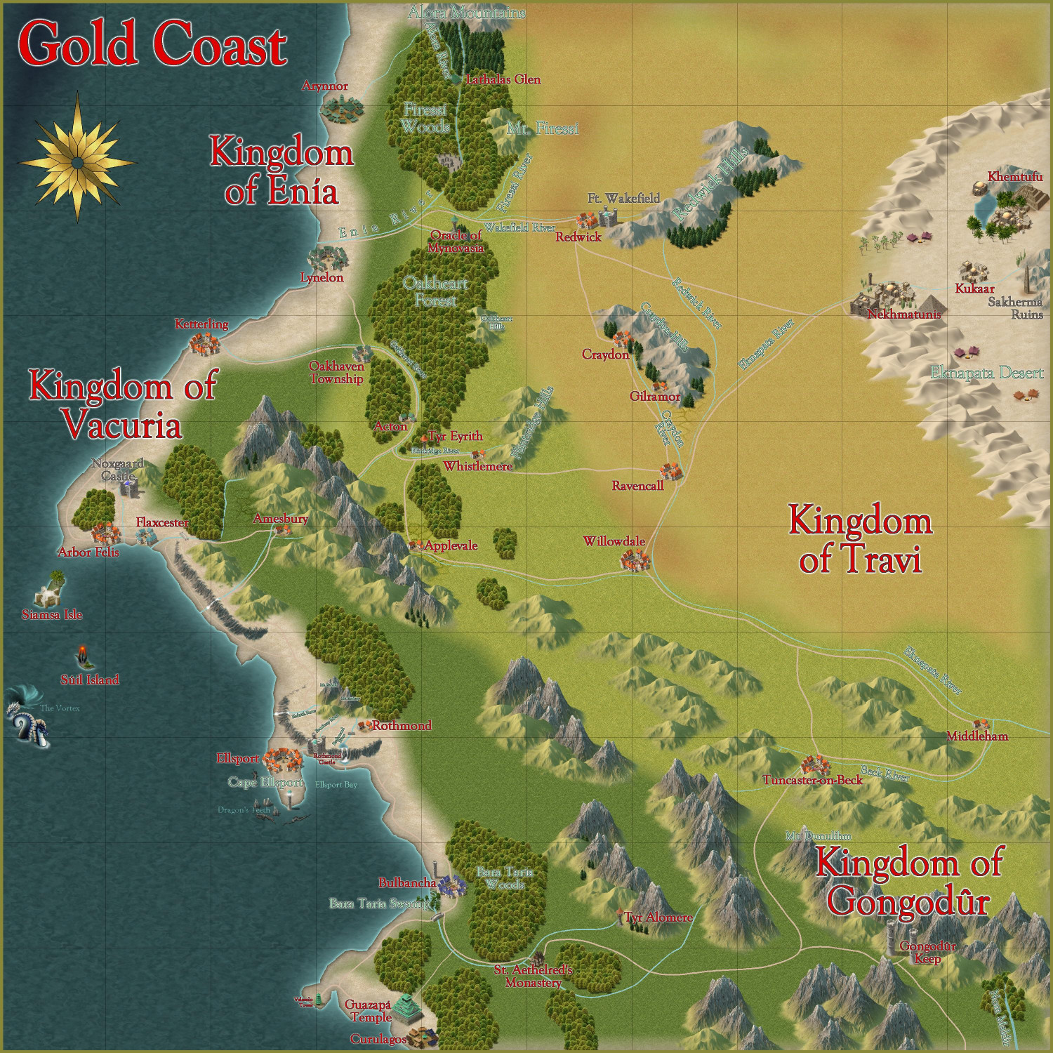
If it's okay, I would like to rename this the "Gold Coast," a regional term for an area so named because of the sandy beaches and tawny dried coastal grasses in the summer. It's an area that encompasses a region that includes a predominantly human kingdom of Vacuria, the inland human kingdom of Travi, a small elven kingdom to the north called Enía (a constitutional monarchy with a hereditary monarch and an elected Assembly), and a small dwarven kingdom in the southern mountains called the Kingdom of Gongodûr.
I still want to create a Borders drawing tool to draw the borders of each kingdom, but for now, this is what I have:
I have discovered that naming things is one of my bigger challenges. For several years, I've been maintaining a list on my phone of fantasy RPG character names, some of which could just as easily be used as place names. I also tried an old trick I used for naming gods in different pantheons in my campaign world: pick a language available on Google Translate and then look up words to find something tweakable for the god. (For a Thor-like god, for example, I might look up words for thunder, lightning, storms, etc. to find a word that could be modified a little to be a name.) And I also found a Wikipedia list of small towns in England and tweaked them (like changing the suffix from -ford to -port). And there are also a whole lot of patterns: a river that flows from a mountain may take its name from the mountain, and the village beside the river might as well.
Questions:
- What did I miss that should be named?
- Do you have any changes to recommend for fonts, font colors, or sheet effects on text labels?
- Any other thoughts?
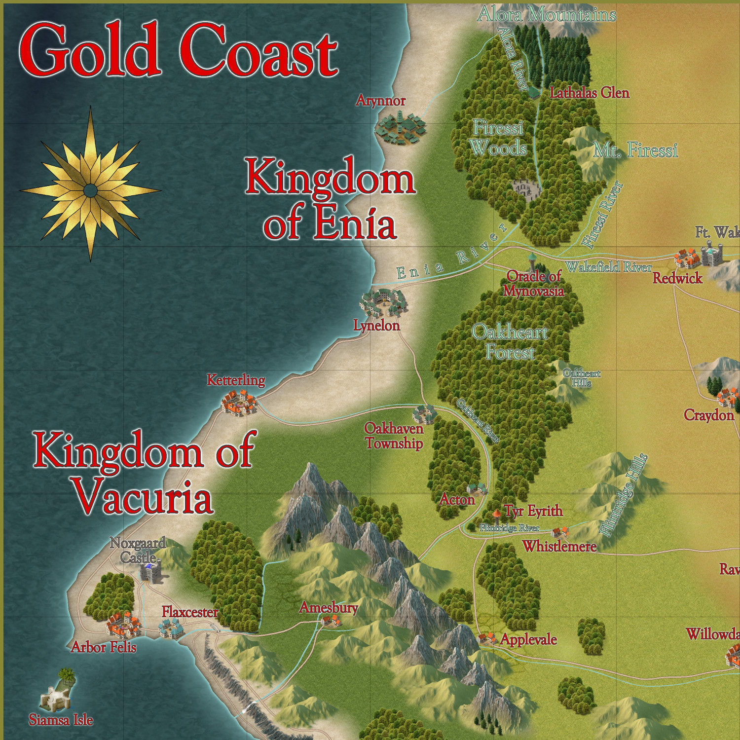
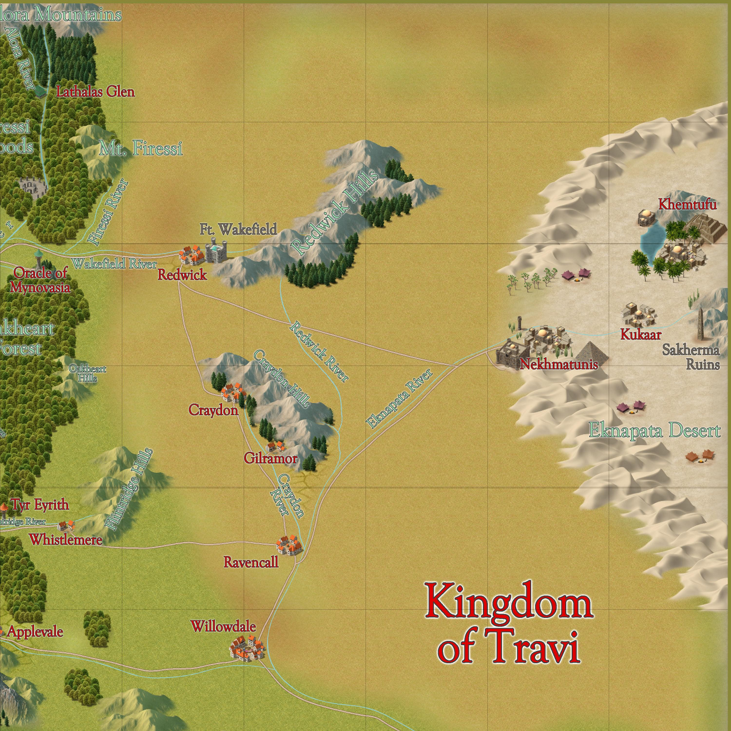
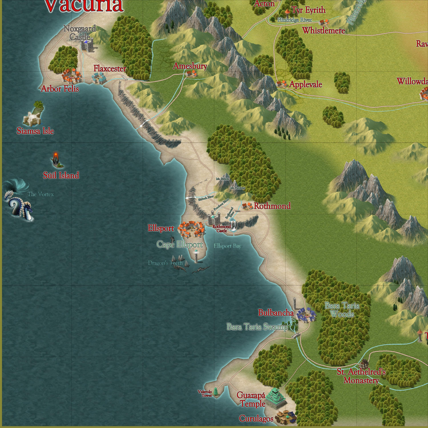
Here are some zoomed-in views to make it easier to see. In the future, would be better to post the larger map in my galleries so that folks can zoom in?


Comments
What did I miss that should be named?
Everything can be named of course, but I feel that huge plain between the desert and the coastal ares deserves a name. It is such a prominent feature. The rest of the mountain ranges, hills and forests would also love a name.
In the future, would be better to post the larger map in my galleries so that folks can zoom in?
If you want people to freely look around the map and zoom in where they want, the gallery is a better option, but if there are specific places you wish to highlight, it may be better to post those views in the post like this. But you'll always have the option of doing both as well.
A good naming site is Fantasy name generators. Names for all your fantasy characters.
Thank you, I've been using it to death! It's the first result when I searched Google for "fantasy city names." Trying to tweak the spelling, or mix up prefixes and suffixes, just so I don't inadvertently end up with a lot of the same names as other people's maps.
I added some names and then posted it to my galleries to make it easier to Zoom in closer if you want. Let me know if you spot anything else I should name, or any other adventure hooks to add at this level (certainly more to come when I start working on detail maps). My plan is to flesh out some of my favorite places by October 1 so there will be a a flood to unleash on October 1.
Remy said two things about the 1000th map contest that I have taken to heart:
With that in mind, I have been working on this Gold Coast map as well as an area map for the Kingdom of Enia, an elvish kingdom on the northern side of the coast. I have two villages in Enia that I will submit. If this works best for you, @Monsen, I will create a thread for all of the non-contest Atlas submissions once they're finalized, and then the actual villages for the competition will be posted in the competition thread when they're ready to submit.
Gold Coast
Here is the Gold Coast region, first without and then with political borders (which can be toggled). I am writing up the description now.
Without Political Borders
With Political Borders
Thoughts?
And then here's a map of the Kingdom of Enia, with more smaller hamlets and other small details added, this time in the Mike Schley style:
Oh, here's a version of Enia with the political borders shown:
Here's an area map of the Eknapata Desert region on the northeast corner of the Gold Coast map. I decided to do it in the Scorching Sun annual. The mapping guide for the annual recommended Mike Schley Overland as a complementary style for additional symbols, so I used that for the pyramid at the city of Nekhmatunis, the ziggurat at the city of Khemtufu, and the half-buried statue and obelisk at the Sakherma Ruins. I also threw in a few of his camel-with-guide symbols to represent nomadic tribes, and a sandworm just for fun. There are a few more villages, too, and another monastery that I figured were too small to be on the parent map for the entire Gold Coast region. I also added a volcano, but figured that would be on the parent map. Since the parent map hasn't been submitted to the Atlas yet, I went back and added it to the parent map, too.
I'm enjoying the opportunity to try out different map styles with this project. I plan to design one city with Mike Schley's Mideastern symbols from SS5, and another with the Desert Oasis annual.
I have a question for @Monsen regarding the Kingdom of Enia area map above. In the lower part of the Firessi Woods, you'll see a little henge and village called Firessi Temple. (The village now has a name, too.) I have a map of that temple and village to submit for the contest. Is it sufficient for the Atlas purposes to link to that village map from this one, or is it preferred that I also do an in-between step, like a map of the Firessi Woods?
That's completely up to you.
The main thing I very strongly encourage when making a non-overland map, is that there is a symbol (or equivalent) on the parent map to link it to. No making an inn and linking it to a blank spot near the road on the parent map because "there could feasibly be an inn here". It is the mappers responsibility to place interesting places in their maps for others to link from, and if no marker for such an interesting place exist on the map, well, then an intermediate map may be required. So generally, the idea with an intermediary map is to make up for "shortcomings" of the parent map.