

Community Atlas: Barrows of the Ferine Magi area, Feralwood Forest, Alarius
 Wyvern
🖼️ 284 images Cartographer
Wyvern
🖼️ 284 images Cartographer
Back for another visit to Alarius for the next segment in my sort-of Dungeon24 mapping (now so delayed, it's increasingly likely to become "Dungeon25" soon...). I noted in the topic for my immediately prior maps, set in the Whispering Wastes of Haddmark, Peredur, that this was scheduled for somewhere in the Feralwood Forest region of northeastern Alarius:
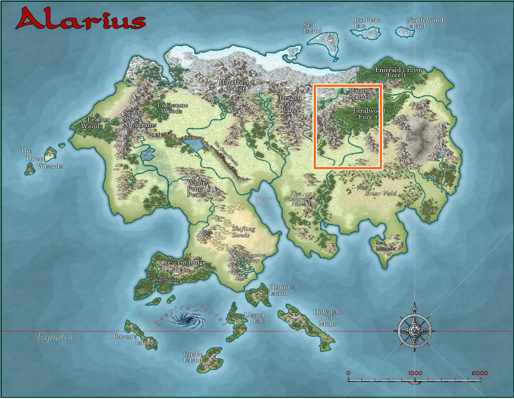
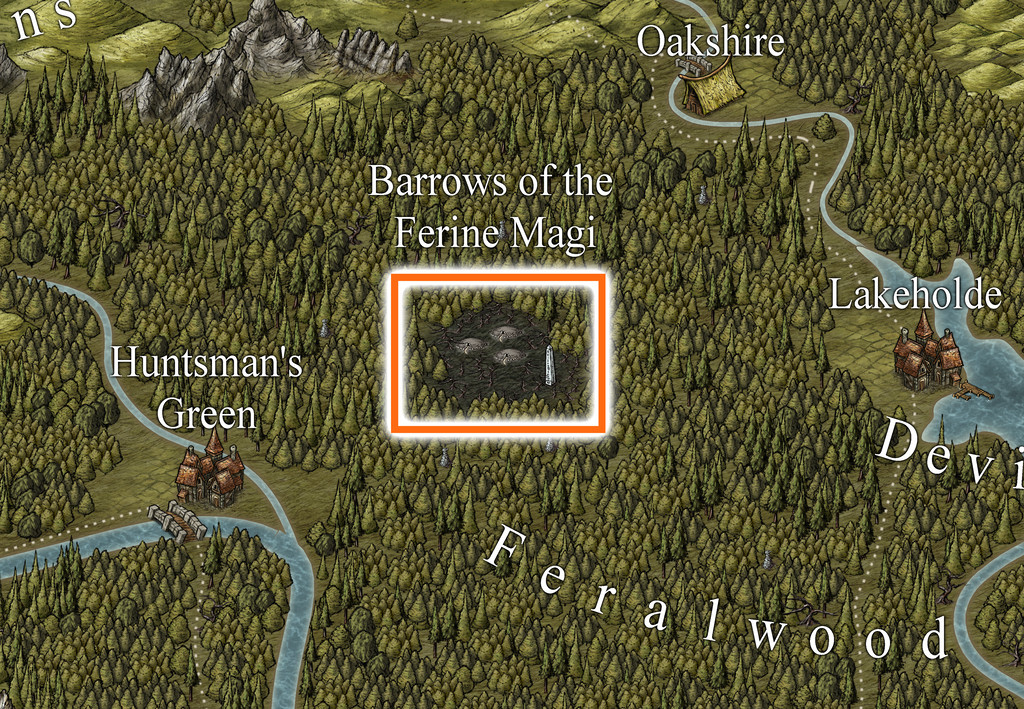
That's a big area, so from the start, I expected I'd be needing to prepare another area map, as well as that for the dungeon. Examining the Feralwood Forest map, it didn't take long to zero-in on a suitably intriguing-looking area, the Barrows of the Ferine Magi:
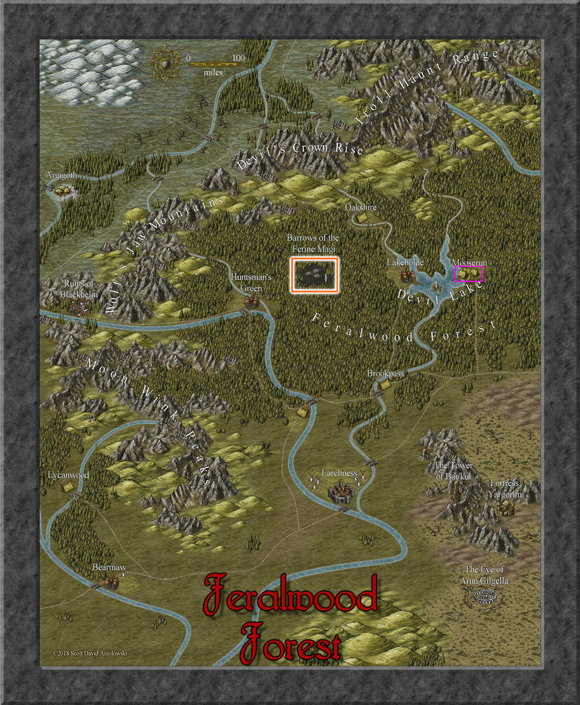
Since the base map for the dungeon was derived from the third of the four generated using the Inkwell Ideas Dungeonmorph "Explorer" dice set, I'd again be aiming for a similar black-and-white design look to the previous couple of dungeon and area maps in this series, including that for this new general area one, which would be done as a hex map once more. So I generated a suitable hex-gridded version of the area, from which to start thinking more about the setting:
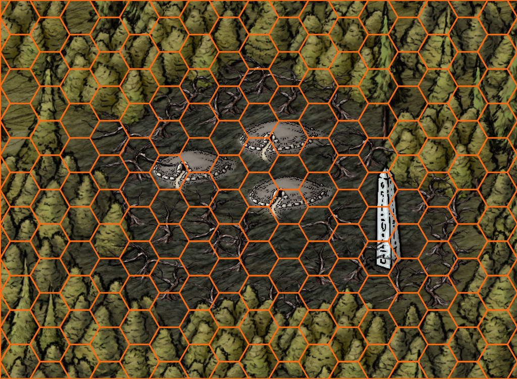
The hexes here are each six miles across in their north-south dimensions.
During the latter stages of the village mapping for the Whispering Wastes, I'd already begun thinking about what might be in this area, as there are no settlements, roads or watercourses shown, just the woods, the central region of dead land, the three barrow markers and the obelisk.
Ordinarily, I, and perhaps many of us, would assume the over-sized barrows were simply markers indicative of a large area, within which might be numerous burial mounds. However, having earlier been working with some of Ricko Hasche's delightfully pictorial maps, where the images for places and features are often hugely over-scaled compared to the physical land area, had set me wondering as to what if those were indeed to-scale depictions of the objects/places involved. An eighteen-mile high obelisk might be pushing things rather, although it could still be taller than might seem "normal". The concept of ten-mile-diameter round barrows though started to take hold.
While the dungeon map to be fitted now to one of these barrows was of the usual quite small size, that needn't prevent it being within a gigantic barrow mound. Burial chambers inside real-world barrows can be very small, compared to the overall barrow's size, for instance. The place-name and that vast tract of dead land all around the barrows also needed to be considered; wild magic from the wild magi that got out of hand in a big way, say.
From that, it was a short step to declare much of the inner zone drained and now devoid of magical energy, so no magic will work there, surrounded by a one-hex-wide ring where wild magic holds sway (the pale white circuit in the next image), and where using magic can be especially dangerous and unpredictable. This is Alarius, after all, perhaps the most magical of Nibirum's continents, so safety catch off! Outside that ring, things are more "normal", albeit creatures from the wild magic zone still might have wandered off there, of course, or indeed into the inner zone, unless they required magic to exist (a magically-powered construct would fail at the border, for instance).
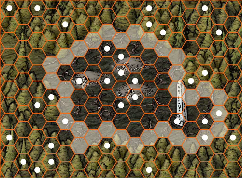
The white small circles on the image above show the randomly-chosen hexes in which there is something of note. The three barrow entrances have also been marked thus, and the location of the obelisk.
What of the barrows? Are they burial mounds, perhaps ones gigantically enlarged by the magical event that blasted the woodlands around them? Or the squashed remnants of once-soaring mage towers? Or something else entirely - such as spacecraft magically ported-in from another dimension? That latter concept intrigued, and in a greatly modified form became the basis for the eventual dungeons (yes, yes, three barrows so now there will be three identical-form dungeon maps from the dice-set base one too!). This drew on ideas from the 3rd edition "Hyperborea" RPG by North Wind Adventures (formerly "Astonishing Swordsmen & Sorcerers of Hyperborea"), whose tagline is "Swords, Sorcery, and Weird Science-Fantasy", the "Metamorphosis Alpha" RPG by James M Ward (in both its original TSR and current, largely unchanged, Goodman Games formats), and especially - thanks to its degree of oddness - Monte Cook Games' "Numenera" RPG, which runs with the concept attributed to Arthur C Clarke, that "any sufficiently advanced technology is indistinguishable from magic", in a world setting of the distant future, where tech is essentially treated like magic. That idea is also an aspect of Metamorphosis Alpha, set on a small-country-sized spacecraft lost among the stars, whose inhabitants have long forgotten they were once its crew and passengers. Thus the "magic" that still functions in the barrow-dungeons is really all technology. For anyone concerned about that in a stricter fantasy setting, I also adopted the Numenera idea that many smaller devices are one-use items. Thus things in the barrows mostly still work most of the time. Things portable enough to be removed may only work once.
So expect a degree of weirdness in the map notes to follow. You have been warned!


Comments
Wow, Wyvern! So much detail.
Lovely maps :)
But do remember Sue, none of these are mine as yet (they're not black-and-white, after all 😉)! The Alarius map was by Shessar, and the Feralwood Forest one was by ScottA. I'm still finishing the CC3+ area map, and haven't started on the dungeon ones yet!
Oh aren't they?
Well, wonderful work by the original artists :)
So finally, an actual map I DID make here!
The area map was going to be drawn and filled first. While the basic format for the style of hex-map was already established, I had some new sets of random design mechanics I wanted to try, to determine what was going to be in those identified hexes. These would later have Shadowdark notes added into the map's PDF file, where relevant, to keep a degree of consistency with the other maps in this current collection.
So the contents for each labelled hex were determined using, or adapted from, tables and random processes in "Into the Wild - Omnibus Edition" (from Third Kingdom Games, 2023). This is designed to work with the Old-School Essentials RPG by Necrotic Gnome, so it draws on creatures from that, and other associated sources among the established "old-school-rules" form of the RPG hobby (as to an extent does Shadowdark). This was my first time using Into the Wild, and it proved something of a challenge, as its layout is not the clearest to find things quickly, or avoid accidentally missing some key element. It did though come up with a lot of interesting ideas, sometimes after a little tweaking, and with occasional additions from the random Shadowdark tables.
The nature of the area, having wildly magical, magic-free and normal magic regions, meant I was looking primarily for unusual creatures or aspects for whatever came up randomly, and so often chose tables accordingly. I also opted to check for both features and creatures in each highlighted hex, again with adaptations, so not everywhere ended up with both elements. One aspect I decided against was involving any high-tech aspects from the barrows also appearing on the surface, as I quite liked the idea that only if a party of adventurers opened one of the barrow entrances and failed to close it properly, might those denizens begin creeping out into the world.
As noted for previous of my area maps, once the features list is decided, other aspects of the map start to fall into place, here including where the streams might lie, as well as larger areas of new terrain types, including some odd, black-sand dunes, and low hills, notably towards the eastern side of the magic-free and wild magic regions. After which it was time to progress to the CC3+ mapping:
This too proved quite a challenge, since the forest density originally hid too much of the normal hex lines (those not highlighted) and had to be revised a couple of times, to try to keep things clear enough while not looking too hex-based. Similarly, ensuring the highlighted-hex symbols weren't overwhelmed by the trees involved more tinkering. The No Magic Zone was possibly the easiest, as it was just the background colour revealed by punching a Color Key hole though the overlying terrain fills, creating the Wild Magic Zone's circuit simultaneously - that circuit achieved by a desert (dot-shaded) terrain fill polygon, without any effects to ensure the edges were sufficiently obvious.
A few extra symbol-shapes had to be hand drawn, such as the little pools (of mercury) in Hex 807, and the depressions in Hex 905 (harpy dust baths), one more of which items was resized and reused as the sinkhole for the stream in Hex 1102. Most other highlighted hex features were either normal symbols, or resized ones (sometimes resized differently in one or both dimensions).
The main drawn items were the three gigantic barrows, which were so large, they needed preparing as specific items. From the start, I thought they'd be more interesting as definite circles, as that seemed weirder than making them less neat and regular, aside from, of course, being easier to draw! Ultimately, I simply drew the first one, then copied it to the other two locations. Initially, I created a new drawing tool to prepare the outer circuit as white with a dark grey outline. However, that proved problematic at the join where the avenue leading in to the centre of the barrow was, with the darker outline showing a break there. Thus that idea was scrapped, and the outer circuit drawn instead using a dark and a white line of different widths on separate sheets. The little cross-lines, helping to suggest the outer stone walling (I've pretty much envisaged these as gigantic versions of the great Newgrange barrow in Ireland), were simply hand-drawn, and are deliberately not all straight or evenly-spaced, to hint at something maybe less manufactured about these structures, despite their overall regular forms. The interior dome was drawn using a Solid White 10 fill circle, or more accurately, copied and amended to be so from one of the outer circuit lines, onto a new Barrows sheet. This had a suitable lighted bevel effect added, tweaked to help darken the domes to make them stand out better. For some reason, the Solid White fill worked better than the Solid one in doing so.
Labelling the map wasn't altogether straightforward either, trying not to hide too many of the dead tree symbols, and avoiding the highlighted hexes, while still making clear what was being labelled. The "Scale" note was the most trying (bottom right corner), as having just squeezed in a "Feralwood Forest" label on that side of the map, I couldn't decide if I should lose the eleventh hex in column 1600 to keep the scaling comment on two lines, or lengthen it to three. In the end, the latter won out, as the map felt lopsided because of that missing end-hex. Well, I kept noticing it, at least!
Onward now to the subterranea!
[EDIT 19 November 2024: Although I originally added the provisional PDF description for the map to this post, I've removed it now, as the final version has been submitted for the Atlas!]
Having decided to prepare three identical layouts for the interior Barrow "dungeons", the obvious first step was to get a version of the hand-drawn map traced in to CC3+ which would then act as a template to be refilled and adjusted for each separate interior, given their contents were not going to be identical. As the general mapping style was already well-established, drawing this was pretty quick and straightforward:
The walls are paler than those in the two previous dungeons in this group, so as to indicate their different character to the typical stonework. The semi-tech setting was going to have plastic-coated metal panelled walls (or something similar), hence this choice of wall texture. While it looks quite straightforward initially, the layout here is actually on three different levels - the rectangular pit in the lower-right quadrant has a raised pathway/passage around it, and a trapdoor access from below into it, as well as two side passageways opening directly into it, for instance, and the elongated side-passages/rooms flanking the long, straight entrance passage (with wall slits into that long corridor) have a bridge accessway over the passage, connecting them to each other and, by secret door, the rest of the complex, though not directly into the entrance route. Took me a while to get to grips with this as well!
While that was all fine, as I was drawing this out, I started wondering about how the semi-tech-world's inhabitants were going to get in and out of here. I'd already drawn-up lists of items and potential denizens from the sources noted back in my first post in this topic, especially the Numenera RPG, and had realized the three layouts would work best with these as workshops, laboratories or a museum. Ultimately, we'll be going with one of each of those. Naturally, some kind of teleportation/transporter beam option was a possibility, for all that felt a little contrived.
Ordinarily, as explained previously, any segments of the geomorphic dice designs that don't link to the main part of the layout, including the connections off the dice edges, are simply skimmed away in preparing the Atlas version. However, now, I started thinking of adding some or all of those external links to this map too, as passages/doors only the semi-tech inhabitants could see and use. This is a shot of the two Inkwell Ideas Explorer dice designs I was using here to indicate what those possibilities were (from dice "V" and "K", in case anyone might wonder about those letter labels):
And this is how they were drawn into the CC3+ plan:
Each new passageway has a wavy line ending it, to show the route goes elsewhere beyond this map, without indicating where that might be, in the semi-tech land that isn't Nibirum. In addition, they've all been set up on the GAME MASTER ONLY Layer, and a series of new Sheets (for the walls, floors, grid lines, and dot-shading symbols), so they can be shown, or not, for each individual layout, something that's intended to be possible via a toggle in the final Atlas version. Each separate layout will have a variable number of these accessways only; the rest will be removed in those final maps. It made sense to draw the set together though, because there is quite an art to doing so, so as not to forget some key element.
While doing this, I next realised the long entrance passage and the rooms/corridors flanking it probably would be in the original Barrow stonework, not the semi-tech walls. This was mostly to avoid the complications of why the semi-tech folks hadn't wandered off into Nibirum at some stage, and more importantly, why they'd have set up a passage with viewing slits to watch for nobody ever coming in down that long passageway! Instead, if this was all the original stonework by the Barrow builders, simple anti-tomb-robber floor pressure-plate traps to shoot darts from magazines that had to be emplaced before the Barrow was sealed, began to crystallize, and were ultimately adopted, as a concept. Thus the wall texture there was changed:
Plus, it no longer made sense to have any linking passageways attached to the semi-tech world from this segment of the layout, so they were removed:
The perceptive among you will doubtless have realised that one other change has been made here, to the semi-tech wall texture. This happened because when I adjusted the new darker wall texture's bitmap scaling, I discovered that, as sometimes happens with the older Annual styles, I had to force the system to use the very high res bitmaps. I hadn't realised sooner that this wasn't happening automatically, partly because the walls lines are quite thin, I suspect. When I did that though, the selected semi-tech texture - the only one that gave a suitably pale appearance - started to vanish into the dot-shading exterior texture in places. This image shows a comparison test, where just the top left room's texture remains as it had been earlier:
Thus I ended up with simple, solid, pale grey wall lines for the semi-tech areas, rather than bitmap-textured ones.
Clearly, this is all still WIP, given that the entrance passageway doesn't go anywhere right now, nor have a blocking doorway to the outside, and the wall around the pit is likely to change too, so it doesn't look like the same solid walls as everywhere else, albeit that may be different for each of the three final layouts anyway. Plus everything needs fitting-out and labelling, something which is still rather in-flux currently, as the lists of items and denizens are allocated and consolidated to their respective layouts. Some progress though, at least!
Well, that was a longer break than I'd anticipated. However, I can now update progress with this project today, having completed the first map, for the Barrow of the Emerald Guardians, and its notes. Typically, if unintentionally, along with other RL issues this month has brought so far, this first map was also the more complicated of the trio to prepare, as it had been randomly assigned both a light generator and lamps, and a pneumatic tube communications system, both of which needed adding to the map. The lamps and generator were straightforward enough, as simple individual fixtures. The pneumatic tubes though needed drawing-in as well, however, given each is meant to be about a foot, 30 cm, in pipe cross-sectional diameter. Lines are, of course, simple enough to draw onto a CC3+ map, but getting the colouring to work well enough in greyscale turned into a bit more of a challenge, and ultimately, I opted for a thin, dark outlining glow effect as well to get the tubes to stand out without making the walls seem like irrelevances. Plus the wall colouring had to be changed as well (several times, in fact, though that doesn't show here, of course...).
This then is the (probably, subject to later checking) final map in its "ordinary Nibirran" view:
And this is the view with the hidden passages those not from Nibirum can ordinarily see, displayed:
In terms of map contents and denizens/potential denizens, these were drawn, and then adapted, from, primarily, the Numenera RPG for this map. In the notes, I've identified the original source object or creature type, in case anyone should want to use the "standard" versions instead of my amended ones, for which I've also provided Shadowdark stats and comments. We have a couple of Human inhabitants, both tech-savvy mage-like inventors of sorts, and a host of curious magic-like gadgets they may have constructed or be working on (or indeed, even be using). There are also oddities from the non-Nibirum world outside (since I've assumed there is a settlement of some sort beyond one or other of the "exit" passageways), creatures that have wandered, or may wander, in, including a particularly vicious group of vaguely humanoid, communal, raiders that communicate purely by telepathy, and which have a thick, long tentacle each instead of a head. There's also a wandering envoy, a loosely insect-like humanoid, jerky of motion, actually a technological construct, liable to be off-putting to folks, despite only wanting to establish peaceful contact with other humanoids. That one can summon a group of warriors of similar type should the need arise, since there seems the possibility for some curious alliances to form among the folks here when added-to by a group of Nibirran adventurers. And then there's also the Mysterion (as I've called it), essentially a Vorlon from the old Babylon 5 TV series, should you recall that. That one's going to be in all three of the Barrows, being extremely cryptical and enigmatic. I did promise weird!
Hopefully, not quite so long a gap till the next map's ready from this trio.
[EDIT 19 November 2024: Although I originally added the provisional PDF description for the map to this post, I've removed it now, as the final version has been submitted for the Atlas!]
A little quicker this time, as the second Barrow map, for the Barrow of the Noble Jewels, had already had much of its layout prepared in advance through last time's "Emerald Guardians" one. This is its "normal" view:
While this is the view with the non-Nibirum passageways revealed:
There was a degree of copying and pasting of items over from "Emerald Guardians" here, including where things had changed since the base map for all three of these designs was laid-out, although I retained the original non-Nibirum wall-line colouring here, as not needing to add the pneumatic tube lines for this map. The Ceiling Lamps are still present in this drawing though. While I did consider moving some about, that really didn't make any sense, as they shed light over a limited area, and with only 20 Lamps to play with, that had already restricted the options in the previous map anyway. I did try to make the exterior sliver on the far left map edge look a little different, and I changed up the look of the railings around the lower level pit in area C, as here, they're meant to be floor-to-ceiling glass or crystal panes, with metal frames, isolating the lower level from the upper walkway completely.
In terms of the contents, most derived from Numenera again, with items and inhabitants both randomly chosen and distributed, although the identical Mysterion makes another appearance, something which, while unstated, gives GMs the opportunity to make things still more weird for visitors from Nibirum who have already met this character previously. There are curious others here as well, including a couple of sort-of, yet not undead, "ghosts", and a superstitious Human Crafter of technology (he's living in a haunted workshop, as he believes it, after all!). Possibly the deadliest creatures are three living-steel spiders, whose web-strands are essentially monomolecular steel threads. They've been set up so opening the door into the chamber they're in will slice off part of the metal door without slowing it, as a warning...
One more of these identical dungeon layouts to come!
[EDIT 19 November 2024: Although I originally added the provisional PDF description for the map to this post, I've removed it now, as the final version has been submitted for the Atlas!]
The last of this, as it turned out, quartet of maps from the heart of the Feralwood Forest region in Alarius, is for the Barrow of the Forgotten Wardens. The layout, of course, is more or less identical to the previous "Noble Jewels" Barrow, except this one has no lights inside, and two of the hidden Transdimensional Passageways are in slightly different places:
It was a little curious that there turned out to be three random exits selected for each of the Barrow maps, and that there was some duplication between the trio for where those exits were. I did consider changing them up for more variety, but in the end decided to let randomness have its way.
I reused the glass-panel railing for the pit section of area C from Noble Jewels, although here the railing is just a metre, 3 feet, high, leaving the central area fully open to the lower level. There are also a couple of new features here, both larger techno-magical items. The Undersea Walker is a vehicle adapted from the Hyperborea RPG. In the accompanying text notes, and as originally intended on the drawing, it partly hides the floor trapdoor on the lower level of area C. However, that wasn't practical on the map for clarity. The Amber Fountain, drawn from the Numenera RPG, is a main food source for the external community not represented on the map, on the world outside that isn't Nibirum, and for which the first Transdimensional Passageway provided a useful choice for its location.
Internally, this layout is essentially an ancient museum, so there are display cabinets with all manner of items extracted from both Numenera and Hyperborea in them, most still functional, if anyone can work out how they operate without draining their power (one-shot items) or accidentally killing someone in finding out. To assist, there is a semi-resident Technosage from beyond Nibirum here, and the whole non-Nibirum section of the complex is surrounded by a functional loop of telepathy wire (also listed among the items from Noble Jewels), so the Nibirese may be able to communicate with her. Rho the Mysterion makes its third identical appearance here as well - another telepathic communicator - along with a couple of weirder denizens from outside Nibirum, as the map notes will reveal.
I've not added the PDF notes here this time, and have now also removed the earlier ones, as the final PDFs and textfiles have been submitted for the Atlas, which should hopefully avoid any confusion as to which version to prefer! I have though added higher-res versions for this map to my Gallery, and am now preparing to move on to the last of the four "Explorer" Dungeonmorph Dice designs in this project, which is scheduled for a home somewhere in the Glaciär Kristol region of Ezrute...
TL;DR But awesome as always @Wyvern
These are now integrated into the atlas. Thanks for the submission.
Thanks very much Remy. And apologies for sending yet another batch of new maps to you for the Atlas yesterday... Still, this way we get to watch the Atlas grow and grow!
Thanks very much Remy. And apologies for sending yet another batch of new maps to you for the Atlas yesterday... Still, this way we get to watch the Atlas grow and grow! 2 🤣