How to use connecting symbols in map with metric system ?
 nxsnexus
Traveler
Hi !
I just bought the Annual 2020 to draw Cliffs. I noticed that this connecting symbol doesn't work well in metric maps. Each symbol is spaced widely making it unusable. I would like to prefer to avoid using maps that are not in the metric system as I quite don't understand the imperial system and don't want to do conversions. I'm not sure it's that big of a deal in the end but it would be nice to have those symbols in a working and usable state for metric maps.
So what can I do to fix that?
Thanks :)
Best Answer
-
 Loopysue
ProFantasy 🖼️ 41 images Cartographer
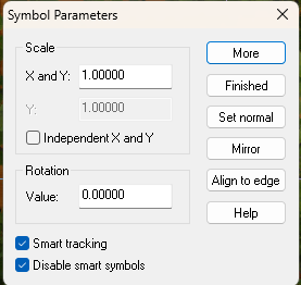
You can do small edits in your metric map by checking the 'Disable smart symbols' box when you right click the map with a symbol on your crosshairs.
Then you can use the individual cliff pieces as regular non-connecting symbols and place or replace them by hand.
The connecting symbol system was developed in the early days of CC when most maps were imperial. Unfortunately the system doesn't work in a metric map if you have connecting symbols with actual corner pieces.
The only kind of connecting symbol that works in a metric map is one that has no corner angle pieces. Unfortunately I didn't realise the problem until after I created the City Cliffs styles, but in more recent years I've tried to create only cornerless connecting symbols where I can - which is why things like the hedges and stone walls in Darklands City and Winter Village will work in both types of map.
EDIT: if you create it in an imperial map and then edit it in a metric map, take care to use the imperial symbols throughout and just scale them up as you edit your cliff in the metric map.


Answers
If you create a blank imperial map in the same number of feet as you want there to be metres in your metric map, and draw the cliffs there, you can then copy and paste them into your metric map and scale them up to fit the metric map borders.
So every modification would make me do a back and forth between the blank imperial map and the metric one, right? That seems rather... Unpractical. I will probably have to simply do a map in the imperial system then.
Cannot we adjust some kind of offset between connecting symbols? Or adjust their settings in some way?
You can do small edits in your metric map by checking the 'Disable smart symbols' box when you right click the map with a symbol on your crosshairs.
Then you can use the individual cliff pieces as regular non-connecting symbols and place or replace them by hand.
The connecting symbol system was developed in the early days of CC when most maps were imperial. Unfortunately the system doesn't work in a metric map if you have connecting symbols with actual corner pieces.
The only kind of connecting symbol that works in a metric map is one that has no corner angle pieces. Unfortunately I didn't realise the problem until after I created the City Cliffs styles, but in more recent years I've tried to create only cornerless connecting symbols where I can - which is why things like the hedges and stone walls in Darklands City and Winter Village will work in both types of map.
EDIT: if you create it in an imperial map and then edit it in a metric map, take care to use the imperial symbols throughout and just scale them up as you edit your cliff in the metric map.
Thank you very much. I could live with manual adjustments!
That's ok. It's still a wonderful software and I absolutely love those Cliffs. I still have trouble using CC3+ properly but I'll get it someday. And corners are what ties the cliffs together. I'll try to do a complete map with it and share it with some Fluff text to illustrate what I tried to do based on my game master's description.
Have a great rest of the day! Thanks again.
You're very welcome :)
If you have any problems just shout.