

Map critique
 JackTheMapper
🖼️ 4 images Traveler
JackTheMapper
🖼️ 4 images Traveler
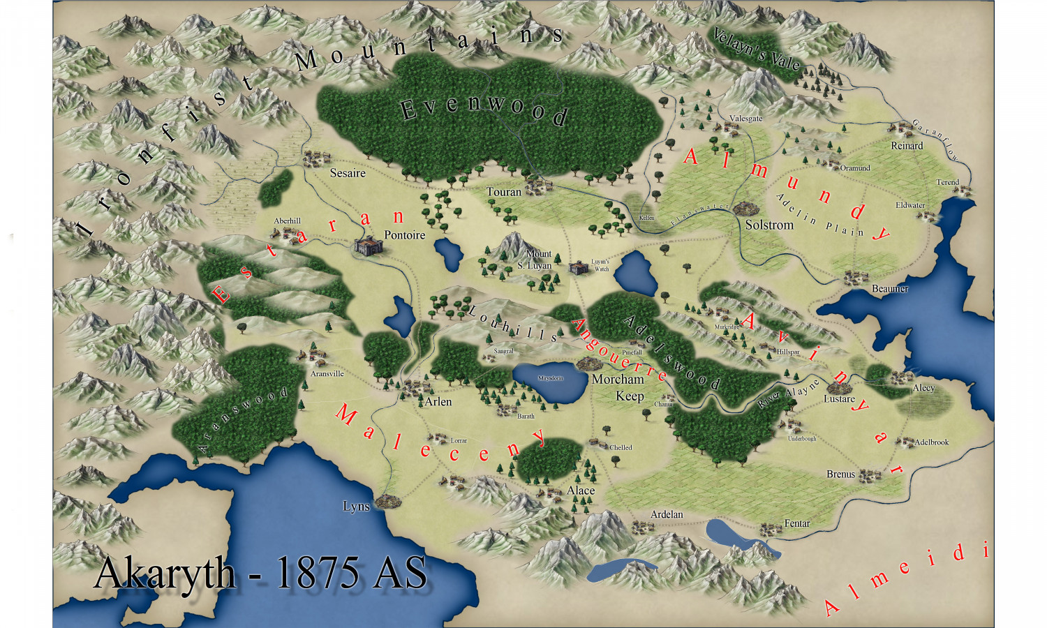
Being new back to using CC3 and related software, this is a project from this morning. It's busy, but it's meant to be as a resource for an RPG campaign I'm running. I'm quite out of practice, so tips, critiques, suggestions, and anything else would be greatly appreciated!


Comments
I think it’s great. My one confusion is that you have lakes that don’t seem to have rovers or streams flowing into nor out of them. Maybe that’s the scale — lots of little streams and creeks but no rivers that would register on a map of this scale?
AH, that's an oversight. I had a weird glitch where some rivers were showing a line in the middle, not curved, like a path overlaid. Couldn't figure out why, so I deleted those rivers and meant to redraw them, but hadn't. Thank you for that catch, I'll add them back in!
It's a nice map, but I think the Ironfist Mountains look a bit sparse right now. Unless it is the intention to have a spare mountain range, I would recommend placing the symbols closer together, making it more dense. Don't be afraid of some overlaps.
Thank you--the Ironfists are meant to be a robust range like the Rockies, that are difficult to cross, forming a natural barrier between Akaryth and the kingdom to the west, Keledon. I considered increasing the size of the mountain icons, and found it hard to fill in the area without it looking too packed. I'll play with it some more. Thank you!
For context here's a map of Keledon that shows its Reaches, or provinces, and a slightly better view of how I think of the Ironfists, seen in the east.
There's a possibility your system's showing "frames" (white lines connecting the nodes on a line or polygon). You can clear those from view using Ctrl + F, if memory serves (and if that's what was happening). It can be useful to show frames, as it makes picking out the nodes easier if you're trying to adjust them individually, but it quickly gets irritating when you're not doing that!
Nice-looking map, certainly!
If you're thinking of further tweaking beyond the point about the mountains (it's never easy deciding how much or how little you can cluster these things; it often depends on the style too, as some flow together better than others, and some styles won't overlap symbols properly), it might be worth adjusting the bitmap fill scaling for the woods and fields a little, to stop the repetition creeping in so much (most obvious in Evenwood), although that's quite a minor distraction once it catches your eye - so, sorry for mentioning it 😏😉...
I'd probably want to tweak the effect settings on the text too, especially the regional red labels that are fading into the terrain a little too much for my eye presently. Text tweaking is always one of the more difficult aspects of CC3+ mapping, as text is something the program doesn't handle as well as it might. It helps if you remember to set the fixed point before placing the text (albeit that gets a bit tedious if you need to change it every time), knowing the text may expand away from that point for different zoom and saved-image settings, or moving it about a little after placement, so that things like text on a curved line avoid having a letter over some key terrain element (always seems to happen for me...). I'd also be inclined to reduce the drop-shadow on the title text, and give that a somewhat broader outlining glow effect, just to help it stand out more than the "normal" text labels.
None of this is essential, or even all that significant, but you did invite comments!
All of this is excellent advice, and Ctrl+F did the trick! Thank you kindly. I'm incorporate your advice and play with the fill scaling on the forests. This is exactly the kind of info I was hoping for!