

WIP - Eastern Continent Of Anarra
 Elfling
🖼️ 1 images Traveler
Elfling
🖼️ 1 images Traveler
Hey all,
I created this map a few years ago for my book, but didn't have the ability at that time to finish it completely. I really like the shape of the land and some of the land features I've laid down. As you can see, I haven't maxed it out with a bunch of symbols yet. Just mainly mountains, rivers and one huge forest at this point. I've recently had more time on my hands and I want to finish it one of these days, especially as I start work on the second book of my trilogy. I would greatly appreciate any thoughts or comments as I plunge back into the task at hand.
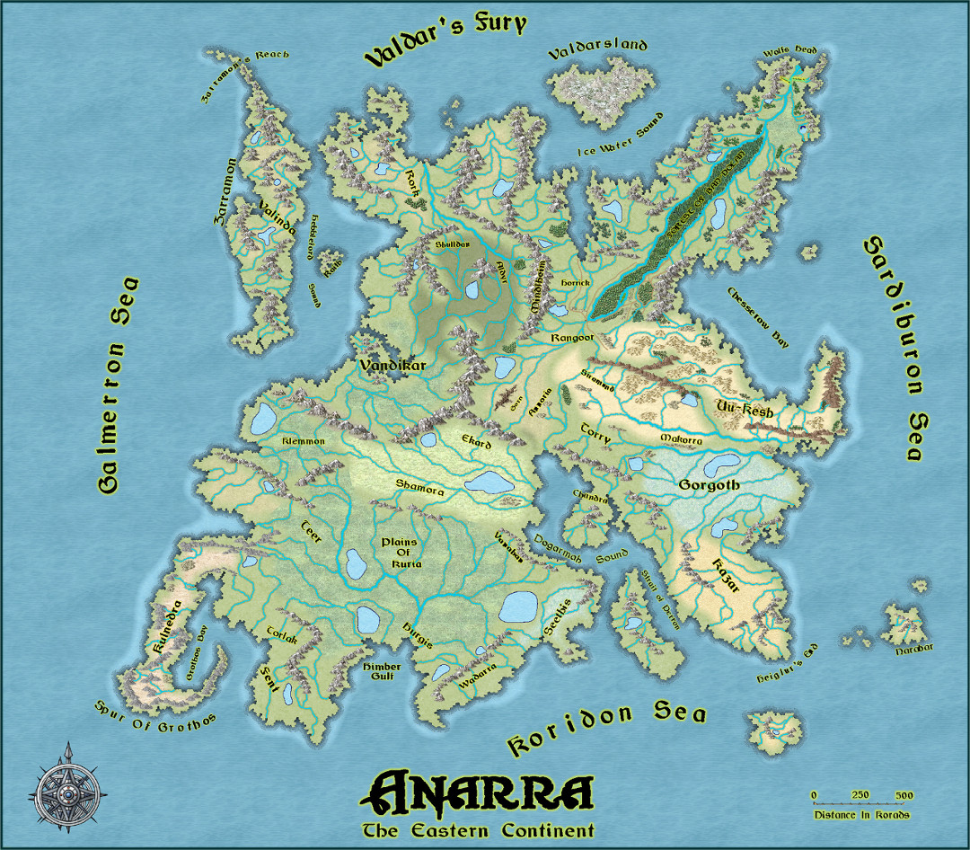
It's about 3500 korads from east to west, and pretty much the same north and south, which works out to be about 2100 miles in each direction. This eastern continent is called Ythira, with the rest of Anarra being completely terra incognita to its inhabitants.
There are vast open grasslands to the southwest called the Plains of Kuria. Jutting out from that is the Spur of Grothos, where the blighted land of Kulnedra is home to foul hordes of Gorguls, loathsome, evil soldiers spawned long ago by Muurdra, the Fallen One. On the eastern portion of the continent, near the equator, lies the great deserts of Uu-Kesh, where rival chieftains engage in constant warfare against one another. Far to the west is the ruined kingdom of Vandikar, once home to the Keldar, noble races of Elves, now scattered across the face of Anarra into seven clans or Noble Houses by the hatred of Muurdra. Imprisoned for a thousand years with some of his mightiest minions in the Outer Darkness, the Dark One even now seeks to free himself from his prison, to once again roam the land, destroying all that is good and pure upon Anarra.
Anyway, please let me know what you think. Thanks,
Elfling


Comments
Yes, it is a nice shape isn't it, but my goodness, that's a very wiggly coastline!
How about making some of the lowland bays a bit smoother so there's a bit of contrast with the wiggly bits?
Other than that it looks really good.
@Loopysue Thanks for the kind words. Yes, it is a rather wiggly coastline, but I tend to think of it as extremely rugged, rather than overly smooth. It's sort of reminiscent of the coast of Norway with lots of twists and turns. The main reason, Sue, is that this map started out long ago as a product of my imagination, long before I discovered Campaign Cartographer, and perhaps even before there was such a thing as ProFantasy Software. I took hex paper, taped a bunch of sheets together, and drew out everything with a felt-tip pen. Different colored pens, as a matter of fact. I was really determined to stay only on the hex lines themselves to see what I could come up with, rather than drawing across them. It was perhaps a lit clunky, I admit, but I actually found it somehow appealing. I'm not really an artist, and it just seemed to give it more of a natural ruggedness that I liked.
I took that old map and scanned all the different pieces of hex paper to give me my coastal outline. I loaded that image into CC3 and traced over it with a fractal coast tool. I tried to follow mountain and river schemes as best as I could, but I haven't completely filled in all the other details as yet. The overall general shape and skeletal structure of the world helps me to visualize where to place things as I write. I guess it's more functional to me than trying to make it into a piece of artwork. I still have only a basic grasp of the software, but I'm learning. Who said you can't teach an old dog new tricks?
Interesting map.
Like Sue, I wondered about the coastline too. It looked a little like some of the automated random map designs that use a hex-map base to generate their outlines; it seems you'd done the earlier analogue version of that!
The river lines seem a little overwhelming currently, and for a map of this scale, there are probably too many. From how you'd prepared the original hex maps, that's likely unsurprising, as you'd be drawing each in far more detail than a continental map would need.
There's an art to working out what should be preserved when scaling-out like this, from a regional/local level to a continent-sized area, which generally devolves to settling on those few, major features to keep, and greatly increasing the smoothing of elements such as coasts and river lines. Not often easy to decide, however, particularly when you're heavily-invested in each little detail!
The relative sparsity of the mountains and forests seems about right for this mapping-scale by contrast, and is perhaps what leads to the rivers and coasts not looking quite right.
Maybe add a few names for some of the larger inland seas?
@Wyvern Thanks for you comments. Maybe I'll try to modify the coastline a bit, if I can figure out how to do that without totally screwing up the whole map. The rivers probably seem a little over the top without a bunch of other symbols to balance them out. Maybe I should tame them down a bit, as well. I do have names for all kinds of places strewn across the map, Alastair, but they can get a little overwhelming when I activate all of them at the same time. To keep things from getting too cluttered I spread the text names out over three different sheets. That way I can activate only the ones I want at any given time. Hence, the first sheet is a sort of minamalist approach. But as it is, things do seem a little sparse across the Plains of Kuria, for example. I should probably move a few more place names to the first sheet, but I don't want to overdo it.
Thanks to both you and @Loopysue for your insight. As I said above, it is still just a work in progress.
I don't have any issue with the coastline. It just seemed like a style choice. However, if it is to look like Norway, it does not. It looks mechanical.
If you want to edit the coastline, you can delete nodes and move some other ones around to alter the look.