

Annual 1, issue 4 - Sarah Wroot map. My example after the Live Mapping session
![[Deleted User]](https://secure.gravatar.com/avatar/c75d9a245b74d9c59be0999ea81ca541/?default=https%3A%2F%2Fvanillicon.com%2F92add7f8c954488718110edc4896ad39_200.png&rating=g&size=200)
I have already done 2 maps for the Atlas in this style. Here is another one for the Atlas, on the East coast of Kentoria.
I have used all shades of blue rather than different colours.

Comments
Some effects on that text would probably be good, much of it is really hard to read. You may wish to remove that hill just north-west behind mt. fanzerut, the line from that one really overlaps the other mountains in a bad way.
Didn't comment on all the maps, but overall a nice set of maps you posted today.
Thanks, will do. Feel free to press the Like button ?
I believe I did :)
Yes, I see them now. Sorry.
No worries. In general, I would encourage people to use the like button as much as possible. That's how people see that others appreciate what they posted. (A nice post is even better, but I know it isn't always easy to have something to say about every map even if you liked it, so the like button is a nice alternative.)
Ok, Mr. Quenten
You and Sue have changed my mind on the Sarah Wroot style ?
I just found her pen and ink mapping style frustrating to try and read in the Dying Earth RPG. It was making my eyes hurt! ?
thanks for giving me the opportunity to appreciate this style!
Cal
An update - corrected text - the glow wasn't showing until I changed from % to map size. I increased font size of the five cities. I changed the colour of the background on some hills. And I fixed all those pesky mountain overlaps. I added shallow and deep sea shading as well.
No idea what the 4 small squares below the top ship are - will delve into that later - I am on someone else's computer today, and so no access to my CC3+ files.
I also created some more vector symbols for a tower, a castle, a lighthouse a wrecked ship and a village. I will also do an oriental city, a few more villages/towns, a ruin symbol, a few religious symbols, another ship symbol and some rocks. I will make them all variable colours, and then give them to ProFantasy for free as a Sarah Wroot add-on if they want them (and to anyone else as well).
I just have to go over the use of symbol background colour to make these symbols the same as Sarah Wroot's. I suspect some of the settlement symbols in the Mercator style would also be reasonably compatible. Instructions would be helpful, and i am rewatching the Mercator video again later today where I think Ralf touched on this.
Here is the final map - a few minor changes, and the map notes. I will submit this to Remy Monsen tomorrow, unless there are some changes suggested by others.
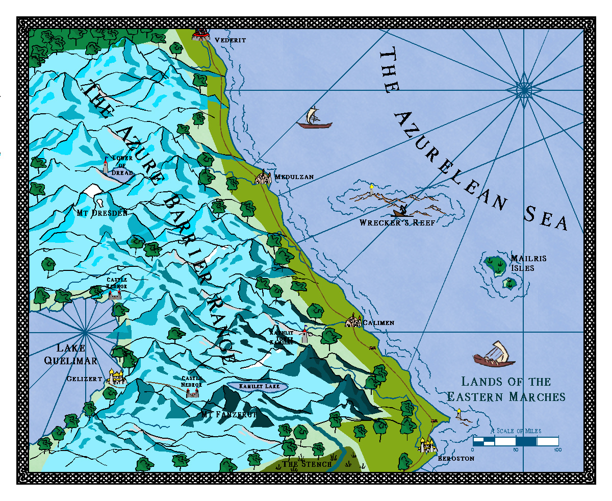
Lands of the Eastern Marches
This region marks the eastern limits of the Kentorian Empire, where imperial rule only exists in the cities of Beroston, Calimen, Medulzan and Vederit. Medulzan is the small provincial capital, where the provincial governor resides.
The coast is well watered, but has stony soils and is not as fertile as the inner provinces of the Empire. The farmers and herders are true frontiersmen, and suspicious of imperial officials.
Apart from the four cities (really large towns), there are several area of interest.
In the Azurlean Sea, is the notorious Wrecker’s Reef, the graveyard of over 30 ships, whose treasures have not all been recovered. A beacon light was installed some 72 years ago, and there have been no more wrecks since then.
Two islands to the south-east of the reef, the Mailris Isles, are windswept and covered with tall grasses and low shrubs. A few hardy souls live there, eking out a living raising sheep and fishing. Their wool is the finest, and they are celebrated for the patterns on their fleecy cardigans.
The coast is bordered to the west by the mighty Azure Barrier Range, the tallest mountains being Mt Dresden and Mt Fanzerut. There are a number of small valleys, where totally self-reliant and hardy folks make a living, with barter replacing money. There is a pass between Calimen and the city of Gelizert on Lake Quelimar, a prosperous city of an inner province. The pass is guarded at the western end by the garrison of Castle Nedror, and at the eastern end by the troops for Magister Rathlit. The pass follows along the beautiful Kamilet Lake before entering the rugged hill and mountain country on either side.
Finally, there is the mysterious Tower of Dread. It has no windows or doors, and is made of a smooth black rock that cannot be scratched, let alone broken. At times, a sinister hum and purple mists emanate from it. No one knows what it is for, but a number of people who have attempted to investigate it have all vanished.
I seem to have missed this earlier, and it's been a bit of a battle to get to it tonight - Forum kept redirecting me for about 15-20 seconds, but it seems to have stabilised for the moment. I hope...
Interesting looking map, certainly.
The trees seem a bit overwhelming in places, contrasted with the settlement sizes. I'm not sure if it's as much the transparency issue though with this style; placement is everything to avoid overlaps, and this looks a little messy in places to my eye. Struggling to follow the river lines in places, for instance.
The settlement and ship symbols seem to have ended up on different Sheets, as some are transparent, others not, which also looks odd, as I'm assuming the lack of a key means these variants don't have some particular meaning.
The navigation lines out of Lake Quelimar into the sea also look a bit confusing, unless there's some concealed connection between the two the lines are meant to represent?
Vederit's too close to the northern map border, I think.
Does the darker shading on some of the more southerly mountains have an especial significance?
I will take some of these suggestions on board, esp the trees.
Once again, thanks for your critique, Wyvern. Here are the changes I have made.
Added to the atlas: