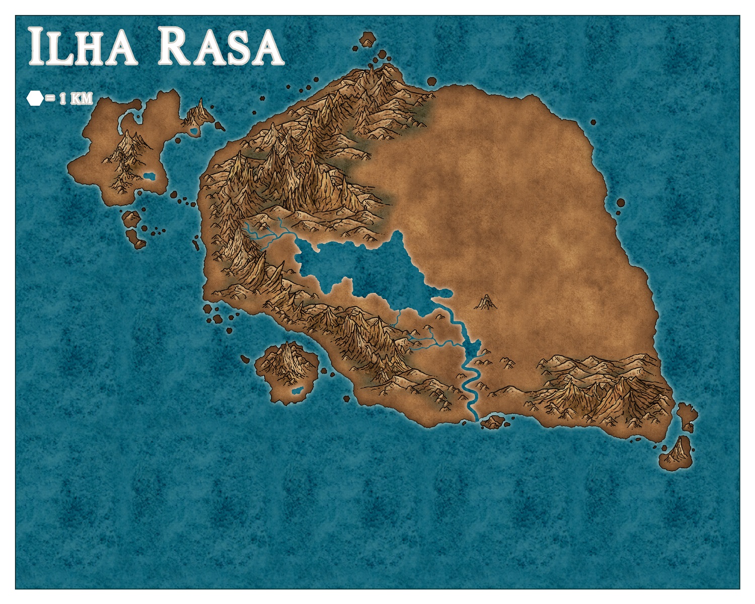
[WIP] Panorica: Ilha Rasa

Just to show the WIP of my latest map =)

I am done with the landmasses and the mounstains/hills. Now I am working on the rivers. Also, do anybody have suggestions in howw can I draw the beaches?

Edit: Final Version
«1

Comments

  • Maybe draw polygons with the same texture as your land and add an inner glow with a sandy colour.

    Just guessing though, the regulars likely have a better way ;)
  • LoopysueLoopysue ProFantasy 🖼️ 39 images Cartographer
    I think Merion has a pretty good idea :)

    Lovely map, Mateus :D
  • LoopysueLoopysue ProFantasy 🖼️ 39 images Cartographer
  • MonsenMonsen Administrator 🖼️ 46 images Cartographer
    Looking nice. I think this will turn out to be a great map.
  • Posted By: MonsenLooking nice. I think this will turn out to be a great map.
    Do you think that I got the scale of the symbols right?
  • MonsenMonsen Administrator 🖼️ 46 images Cartographer
    Looks good to me, but the scale of individual symbols is more what you want to do with the map, there isn't a single solution there.
  • Mateus090985Mateus090985 Traveler
    edited March 2020
    What about these beaches? I created it tracing the coast. Then I add a Edge Fade Inner with 50% opacity
  • Looks great!

    If I had to find some criticism though, it's that in the real world, there are seldom beaches all around. They usually just are on one side of an island - due to currents or only on the concave parts of the coastline, where the sand is caught and on the tips of land inbetween the currents take the sand away and leave rock. But that's just a minor point and does not apply always. In a shallow, sandy sea you could definitely have something like this. And in a fantasy world anyway ;)
  • Posted By: MerionLooks great!

    If I had to find some criticism though, it's that in the real world, there are seldom beaches all around. They usually just are on one side of an island - due to currents or only on the concave parts of the coastline, where the sand is caught and on the tips of land inbetween the currents take the sand away and leave rock. But that's just a minor point and does not apply always. In a shallow, sandy sea you could definitely have something like this. And in a fantasy world anyway ;)
    Excelent point Merion. I did not knew that. Help me here. The mountain part of this island is the side that is oriented to the main continent and the most vicious currents ran there. So the beaches makes more sense there or on the other side?
  • MedioMedio Surveyor
    Looking good!

    The beaches need to be a bit more polished. They look too ... poligonish. The forest background needs some effects ( some edge blur for sure). The river and lakes placement is fantastic, although im not too sold on the bright contour, i´d try a dark one.

    Apart from these small things which will improve over the development of the map, everything is going fine. Good job!
  • Posted By: MedioLooking good!

    The beaches need to be a bit more polished. They look too ... poligonish. The forest background needs some effects ( some edge blur for sure). The river and lakes placement is fantastic, although im not too sold on the bright contour, i´d try a dark one.

    Apart from these small things which will improve over the development of the map, everything is going fine. Good job!
    Thank you very much =).

    About the beaches. How do you think that I can made them less "poligonish"? I am out of ideas here...
  • LoopysueLoopysue ProFantasy 🖼️ 39 images Cartographer
    I too am curious to know what is meant by "polygonish". Do you mean the hard edge?
  • I forgot how the effects order worrk... What is better to come on top? Blur or Edge Fade?
  • MedioMedio Surveyor
    Posted By: LoopysueI too am curious to know what is meant by "polygonish". Do you mean the hard edge?
    I mean that it´s too noticeable the polygon which he put there (which btw mostly fills every single inch of coast). Too... regular. I know it´s not as easy, but i´d play with it giving it a way more irregular shape.
  • LoopysueLoopysue ProFantasy 🖼️ 39 images Cartographer
    Medio - sorry, I'm not really getting what you mean, but don't worry too much about it. I quite often completely misunderstand things :)

    Mateus - it depends what you want it to look like. The topmost effect will happen first, so the order you have it in the shape will be edge faded, then blurred. If you have them the other way around it will be blurred first.

    What does your shape look like without effects on? And what do you want it to look like?
  • MedioMedio Surveyor
    My poor English must be the issue - what i was trying to say is that the smooth polygon he created to make beaches looks like that, a polygon, if you look the map. You can clearly see it´s a smooth curve polygon going close to the coastline.


    Not sure if im doing it well :D
  • LoopysueLoopysue ProFantasy 🖼️ 39 images Cartographer
    Oh, right.

    I think that's how its supposed to look, Medio. I don't know. Maybe it will look different to that when Mateus has finished the map ;)
  • edited March 2020
    To me, the beach polygon currently looks too much like a contour line, so it makes me think there should be others inland. It also makes me think there's a sudden drop - like a low cliff-line - towards the coast (so there should be waterfalls on the rivers, which there clearly aren't!).

    I suspect only adding some beaches in selected places, rather than all round the island, would be the solution, as mentioned already.

    Beaches tend to form in coastal bays, or anywhere the coastline bends concavely into the island and the water runs a bit less fiercely. Headlands tend to be rocky, ending up that way as they're more resistant to wave erosion. There can be exceptions (like a beach on one side of a headland, where it's protected from the currents, say), and finding explanations for why things don't fit with expectations in both the real and fantasy worlds, can be a large part of the interest in examining or adding such features.

    For symbol sizes, aside from whether they look right to the creator's eye, it's useful to know what the scale of the map is. Without that, it becomes just a guessing-game for anyone else trying to comment :)

    To my eye, the mountains seem large and very numerous compared to the paucity and general narrowness of the streams coming off them, but that's just me! The size of the woods suggests more streams are still to be added, so this comment probably isn't much use just now, for instance.

    With the Sheet Effects order, use trial and error. Some Effects create a massively different look to the map by being in one order than another, though not all. Move the dialogue boxes to one side, so you can view part of the map where the Effects will happen most clearly. Then using the check-boxes, editing values per Effect, or swapping the order of the Effects, hit the Apply button to see what difference each change makes to the map. Once you're happy, you can click "OK" and move on!

    It is worth playing around with these things, because sometimes you'll find a completely unexpected thing happens which is better than anything you'd thought of (and by "you" here, I really mean "I"!).
  • Thank you very much Wyvern for your comments! The scale is already in the map. 1hex is 1km. I am still drawing the woods/forests and the rivers. I also still need to add terrains in many parts.I would love to add at least one waterfall but I have no idea how to draw them...

    I will try to work in the beaches a bit more. Thank you guys for the suggestions.
  • Sorry Mateus, I should have been clearer about the scale issue; one of the dangers of typing while not still looking at the thing you're typing about... I find it difficult to translate a hex scale with any precision, because which part of the hex is actually the scale length? Flat to flat, or point to point? Or somewhere in between? In this case, the hex is quite small, so that's maybe not so important, but then the mapped area is vast compared to the scale hex, so there's the problem of trying to extrapolate from that one tiny hex to features that are many kilometres across. If the map is a hex map, this isn't a problem. Here, to me at least, I think a linear scale would be more helpful.

    On the waterfalls problem, you may find this topic by Loopysue useful. It's from mid 2016, but is just as useful now as it was then, I think, and is largely - from about halfway down the first page - about creating waterfalls and effects to enhance them.
  • Here is my progress. I gave some steps back and some foward =)

    I did a lot of more work in the rivers. They are almost done I think. I also improved the work in the vegetation and used a drop shadow effect (it can probably just be seen in the zoom cut). And I tryed again the beaches. I did just one.
  • Mateus090985Mateus090985 Traveler
    edited April 2020
    Here the cut. Can some one help me in one thing? How can I put the shadow comming from the base of the tree?
  • edited April 2020
    I think by changing the angle for the Global Sun setting (trial and error, as I can't recall how it works offhand right now!), and also the distance the drop shadow will be from the symbols. Unfortunately, the Effects look only at the opaque parts of the symbol; the system doesn't recognise which is the "base" and which the "top" of a symbol, so the work is down to the map creator to get the shadows to look right. You also have to watch for where the shadows are drawn on the symbols themselves, because that can't be changed, of course. Indeed, some symbols already come with drop shadows added.
  • MonsenMonsen Administrator 🖼️ 46 images Cartographer
    edited April 2020
    Also make sure you use Wall Shadows, and not Drop Shadows. Drop shadows are meant to give an illusion of "floating" objects, which is not what you want.
  • MedioMedio Surveyor
    That beach now looks great :) Congratulations
  • Ooooooook. I am not done yet. But I am near finishing the map. What you people think about it?

    And, one question. How can I make the program to not cut my decorative border? I have to export it using the "rectangular section" option?
  • LoopysueLoopysue ProFantasy 🖼️ 39 images Cartographer
    That's looking really nice :)

    Now to solve the cropping issue.

    How are you exporting the map? What sort of bitmap export are you using, and what are the settings?
  • LoopysueLoopysue ProFantasy 🖼️ 39 images Cartographer
    Ok.

    Move the nice frame you've added onto the MAP BORDER layer using the change properties tool. Please note - that's the layer I'm talking about. It can stay on whatever sheet you've put it on.

    Things on the MAP BORDER layer affect how CC3 crops the export when you have the Restrict image to map border checked in the options.

    Try it now :)
Sign In or Register to comment.