

Importing SRTM data (realworld high resolution terrain data) into FT3

If you want to import high resolution real world terrain data directly into FT3 (Fractal Terrains 3) then you can do this quite easily by following these steps:
1) Download SRTM terrain data (the files can be downloaded for free).
-> there are 1" and 3" resolution files. While the 3" resolution files can be found for nearly all over the world, 1" resolution files are somewhat harder to find and not for all regions as far as I know.
-> 1" resolution is about 30 meters and 3" about 90 meters horisontal
-> 1" are about 25 Mb in size, 3" about 2,5 Mb.
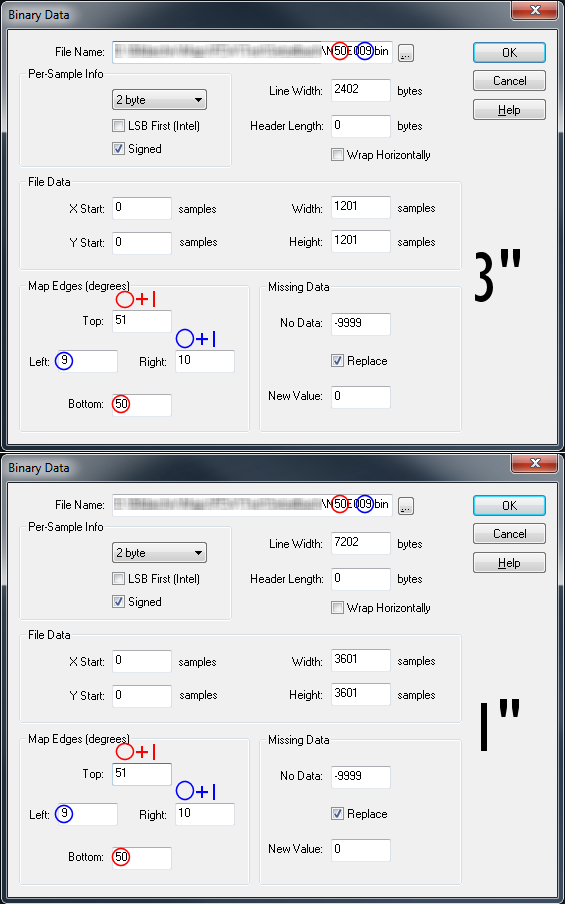
-> 1" contain 3601 x 3601 height points in a 1 x 1 degree square, while the 3" only contain 1201 x 1201 points
-> the file name contains the coordinates of the southwestern corner eg. N50E009.hgt contains data from 50 degrees north to 51 degrees north and from 9 degrees east to 10 degrees east
(1a) Rename the .hgt file to .bin (this is not really necessary)
2) Choose the SRTM file by -> New -> Binary File -> Choose Elevation File -> click on the ...
---- If you renamed the file to .bin you can find it directly with the file-filter "Binary Files *.bin" (default) or by selecting "All Files *.*" if you did not rename the file as mentioned in 1a)
3) Fill in the values in the "Binary Data" dialogue as shown below
4) Possibly you do not see anything in the equatorial map at first. You have to zoom in to the area that your SRTM file covers - keep in mind that it is a rather small part of our the world.
This works only for one file at a time.
I have even a solution for multiple files but that is quite a little more complicated...
/André
1) Download SRTM terrain data (the files can be downloaded for free).
-> there are 1" and 3" resolution files. While the 3" resolution files can be found for nearly all over the world, 1" resolution files are somewhat harder to find and not for all regions as far as I know.
-> 1" resolution is about 30 meters and 3" about 90 meters horisontal
-> 1" are about 25 Mb in size, 3" about 2,5 Mb.
-> 1" contain 3601 x 3601 height points in a 1 x 1 degree square, while the 3" only contain 1201 x 1201 points
-> the file name contains the coordinates of the southwestern corner eg. N50E009.hgt contains data from 50 degrees north to 51 degrees north and from 9 degrees east to 10 degrees east
(1a) Rename the .hgt file to .bin (this is not really necessary)
2) Choose the SRTM file by -> New -> Binary File -> Choose Elevation File -> click on the ...
---- If you renamed the file to .bin you can find it directly with the file-filter "Binary Files *.bin" (default) or by selecting "All Files *.*" if you did not rename the file as mentioned in 1a)
3) Fill in the values in the "Binary Data" dialogue as shown below
4) Possibly you do not see anything in the equatorial map at first. You have to zoom in to the area that your SRTM file covers - keep in mind that it is a rather small part of our the world.
This works only for one file at a time.
I have even a solution for multiple files but that is quite a little more complicated...
/André
Comments
There is some other GUI where you can input the map center. Is that supposed to keep the map centered in the desired location?