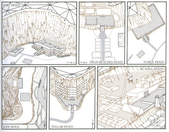
Idea for an Annual or Help so I can create maps like this!
I would love to see Annual done so I could make maps like the one in this Photo Ive Attacted. Ive been trying to work it out but can't seem to do it yet. For those of you who have Read any of Anne McCaffery's "Dragonriders of Pern" you should now what these maps are. I would love to be able to create the Floor plan veiw like the one labled "High Reaches Hold". The others Give you the Idea of versitility I would like. But Im having a hard time with it as I would think it would need to use City Designer, Dungeon Designer with floorplans. I've seen maps done with either one or the other but not a combination even though I believe it is suppose to be possible. I think that a style like this done not exactly like the drawings but like the color dungeon and city style would be great use to all Mappers out there. So I would really like to see This as a "ANNUAL ISSUE" for those of use that are not able to figure out how to use different addons in one map or or create a template to use to do this. I would love to see either a video tutorial to show how to create some thing like this or the Regular annual issue, either with templates to create these style in Color. Please help


Comments
It's difficult to create a ready-to-go style for this, as depending on the layout of the depicted stucture/area, the setup of sheets and layers might need to be pretty different.
I'm also reluctant to do it as an Annual style, because it would require Perspective to work, an add-on that is not so widely present as DD3 or CD3. We'll think about it.
(unhide the MAP BORDER sheet to see your plan underneath)
I will try the annual out and see if it helps me to create the style pack I want. I just know that Im not the expert that you guys creating the annual style packs are. Plus I've noticed in the Version 3 like CC3, DD3, and CD3 that you can not switch between them using the buttons and then use the basic tools located up in the top left corner as you could with the CC2 versions.
I'll work on seeing what I can do, but I just thought that you guys would be better able to do it as your the experts and it would be a great annual issue and many mappers could use it.
The X is where I put your jpeg (the relevant part, that is). And I traced over it.
I used lines, arcs, offsets, triming and fractal lines with a low fractal depth.
I don't really see how you can involve symbols in such a drawing except perhaps in ready made cliff faces.
I' ll look at the mentionned video asap.