

Fractal Terrains Project - Caledis (WIP)
 LadieStorm
🖼️ 50 images Surveyor
LadieStorm
🖼️ 50 images Surveyor
I got Fractal Terrains for my birthday, and I've been doing a lot of playing around with it, trying things out, attempting to see what does what, trying to figure out how to use it. I actually have been reading the Tome Fractal Terrains chapter, but I'm afraid most of it is going right over my head. There are a lot of 'technical' terms that might as well be a foreign language for all that I understand it! That's not a complaint, just an observation  .
.
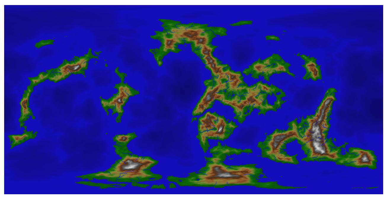
Never the less, I am attempting my first FT world, one I call Caledis. I'm trying to do as much of it as I can in Fractal Terrains, then finish it up in CC3+. But I'm having some issues. I'll post my project, issues will follow in next post.
Never the less, I am attempting my first FT world, one I call Caledis. I'm trying to do as much of it as I can in Fractal Terrains, then finish it up in CC3+. But I'm having some issues. I'll post my project, issues will follow in next post.
Comments
Now, as you can see, I have already set my rivers. And I've already noticed that I need to lower elevations in certain areas, so that my rivers will flow all the way to the sea... right now, most of them do, but some of them don't. I think I have a handle on how to do that.
Here's issue number one - I have land masses, with rivers. I have elevations. I believe there should be a way to add mountains, different types of forests and other terrains, based on buttons down the left side of my work window. First question: Does Fractal Terrains calculate where the forests and different terrains are likely to be, based on climate, rainfall, temperature, river flow and whatnot? From what I understand, Fractal Terrains is designed to make worlds that are 'more real' based on these things.
Second question: Those greyed out buttons on the left that are for mountains, grassland, forests and what not... how do we use those? I can't seem to activate them... and I've probably read something about it in the Tome, but didn't realize what I was reading, because the Tome kind of went over my head when it came to FT3.
I will probably have a multitude of questions as I work through this project... but these two are most prevalent at this time.
FRACTAL TERRAINS DESIGN
Setup
On the Map menu –
World Settings:
Fractal Function:
• RMF with Perlin’s Improved Noise;
• Automatically set Parms;
• Parms > Octaves 24
Primary:
• Altitude: 30,000’ - -30,000’
• 25,000 miles circum
• Roughness: 0.85
• % Sea: 70
• Land Size: 2.0 – 2.1
Secondary:
• Continental shelves to ~ 1000’
• Change to metric if you prefer
Editing:
• Custom size: 4096
• Allow prescale offset editing
Keep Temperature and Rainfall as is, and I also keep Selection as is.
Change Projection:
Whatever you want, say equirectangular (the most popular)
Lighting and Colour:
Colouring Scheme:
• Try them out, but I suggest 15-9 to begin with. You can always change them later.
The rest I leave as is till I have my map done.
Add grid - use white colour, and the default settings. Finish up with lines at 0, 30 60 latitude, which helps in deciding climatic zones.
Initial Creation
Tools menu
Go to Paint Raise/Lower> Prescale Offset
Set at 0.01 – 0.05, tool size 100 – 250 (change the size of the tool when getting to really small details like small islands.
Go to Actions submenu
A Fill in lakes
B Expand land on 1 side of mountains, and reduce it on other, and generally raise and lower altitude for both mountain ranges, tinkering with coastlines, adding islands great and small, even substantial land masses, and don’t forget ocean highs and lows, if you want believable tectonic plates.
C Global Smooth > Prescale Land Offset value 1
D Tools > Actions > Fill basins in offset
E Global Smooth > Land Offset (NOT Prescale) value 1
F Tools > Actions > Incise Flow: amount 3.5; Flow 0.35; Effect 0.25; Blur 2
G Fill Basins
H Global Smooth > Land Offset value 2
I Tools > Actions > Incise Flow: amount 2; Flow 0.1; Effect 0.1; Blur 0.5
J Fill Basins
K Global Smooth> Land Offset value 2
L Planetary Bombardment
M Tools > Rivers > Find Rivers > Fine. Pick value of 2.0, Potential flow.
Climate
Use Tool size of 100-200.
Increase Temperature and Wetness in latitudes 20 N to 20 S
Reduce Temperature and Wetness in latitudes 40 N – 20 N; and 40 S to 20 S
Reduce Temperature and Wetness in highest latitudes N and S (~ 75N and S)
Check Climate Map. If necessary, paint climate, esp ice and deseret. in poles. Can also get ice at poles by dramatically reducing temperature in the 75-90 latitudes N and S.
Export to CC3+ another cheat sheet will follow if you like.
Here is a world created just for an example at the beginning (about 1 minute to find it, and 1 min to set the settings at what I wanted, as above):
You can directly force-paint a climate type using Tools>>Paint Values>>Climate. I would generally recommend not doing so for two main reasons: (1) the painted climate won't blend smoothly into the surroundings, but will have square edges at your editing resolution and (2) the temperature and rainfall under your painted climate areas won't be affected by the painted climate. At one point I had considered trying to make a climate painter that actually would drive temperature and rainfall into the nearest bin of the selected climate type, but it would be painfully slow (at least it would have been 15 years ago) and most likely drive some intermediate climate types into some unpleasant states.
Quenten, I realize you are trying to help, by telling what to set tools, climate etc... on, and I really appreciate you doing so. The problem for me is... If you are telling me WHAT to do, without explaining HOW, or more importantly, WHY I'm doing this.... then it's just gibberish to me. It doesn't really tell me anything. Or, more accurately, I'm not really learning how the program works to make what [b][i]I[/i][/b] want.
For example... everything I've read, says to set the Altitude range at 30000 to -30000. Why? From what I've seen so far of FT3, when you use those ranges, most of the terrain on the worlds that are created, tend to be around midrange, around 10000-20000 ft. If I'm building a 'realistic' world... at those ranges, most of my land masses are uninhabitable by anything that breathes oxygen, because oxygen is too thin to breathe at altitudes higher than 12000 ft? And having depths beyond a certain range will cause water pressure to crush anything down there. So I don't want those altitude ranges for my world. I want a world where even my highest peaks 'could' be inhabited.
RMF with Perlins Improved Noise? What does that do? Why is it different from any of the other options?
Automatically set Parms? What in world are Parms? And why do I want to set Parms> octaves 24? What does that mean? What does it do?
The roughness, land size, and ocean size I have set the way I want. That much I understand.... playing around with things showed me what they do, so I can determine what I want, and set those parameters accordingly.
Custom size : 4096. Why that number? What happens if I go higher? lower? What does the custom size tell the program? How does it change my map?
Basically, Quenten, what I'm trying to say, is that as much as you were trying to help... and I really appreciate you were trying to help!... you went right over my head, just like the FT tutorial and the Tome.
Joe, the tutorial link you gave me is a little better, it explains that the tools I've been using so far is a little outdated, I guess? Or, rather, the default tools better serve older computers that don't have the memory, or the ram that computers of today have. I get that part. I CC3+ and FT3 on my main laptop, where it needs to be to function correctly... but ALL of my maps are on my external hard drive, which is a terabyte hard drive... so I think I'm good on that.
The one issue I have with the tutorial link you sent me, is the same issue I've had with all the others... it doesn't quite explain the why's and the what's... for example : using the Prescale Offset Editing... what is that? how is it different from the defaults? HOW do I set the parameters of these tools?
One of the things I've noticed, changing between the different... views... I guess they would be? Altitude, temperature, rainfall, climate... You can't seem to overlay them, or combine them. What I mean is... take my map above... you are seeing the altitude view. This is the view I've been using to shape the continents and islands on my world. Now, let's say I decide to switch to the rainfall view, so I can determine if that needs to be tweaked(even though I'm not sure how, or why to tweak it). When I switch to the rainfall view, everything changes. I can no longer see where my landmasses are. Rainfall happens over landmasses as much as it does over water, but as far as I can tell, my heaviest rainfalls occur out in the oceans. I'm not sure about that, however, because in rainfall view, it's showing me where most of my rain falls... but it doesn't over lay the altitude map, so I can't tell for sure if it's raining over my landmasses or not. So I can't tell if they need to be moved, tweaked... and I'm not sure I know how to tweak my rainfall if it does need it! I mean, I know I use the tools to do it, but how does it work? Why would I want one set of values over the other?
I guess what I'm observing, is that all of the tutorials I've seen, assume I understand what these terms mean, so telling me to set this one as opposed to that one it's assumed that I understand what I'm doing. I don't know the difference between equitangular and the others. I dont' know the difference between prescale offset, and regular offset. I don't know what Incise Flow is... the list could go on.
FT3 is a whole different story! I feel like I have to be a computer programmer to understand the tutorials and the Tome at this point! I know that's not the way it's meant to be...but it's like I need a programmers dictionary to translate. Which is why I'm so lost
Prescale Offset gives much finer control over raising and lowering altitude. (how, is a program thing i don't begin to understand; why.. well it gives better control)
Incise flow is found in the Tools>Actions submenu. This gets better more realistic mountain ranges and valleys.
The ranges are not too bad on my maps, but you can set the range at the top to a lower level.
The custom size gives more detail the higher it is set, and 4096 is the maximum. You get an idea of the detail by the distance given in miles (Resolutuion) at the price of a large memory map, on the Editing submenu on the World Settings tab, in the Map pull-down menu.
To change to size of the brush, go to the bottom line of the screen where you see a number for width, height and value. Change these as you wish. Use the values I gave as suggestions first, to get a feel. You have to select an action (raise or lower altitude/rain/temp/prescale offset/roughness first, of course, then the bottom line should automatically appear. Hope this helps. I think I have gone over most of your questions.
Okay, so Prescale Offset is a better version of the default tool. I noticed that the 'allow prescale offset' is already checked. Does that mean my brush is already working at the higher function?
I also noticed that you mentioned expanding land on one side of mountain ranges, and lowering it on the other side... I'm assuming that is so my mountain ranges aren't all in the middle of the land masses?
And I tried using the actions fill in lakes, as far as I can tell... nothing happened. Does that mean I need create basins? How do I know where to make believable basins for lakes?
I also notice that I do have a couple of lakes that have now ingress or egress. And I didn't quite understand how to fix that.
I can't help with why you no longer get the paintbrush menu showing when you select an action - hasn't happened to me (so far).
You are right about the mountain thing - FT tends to put the mountains in the middle.
If the prescale is already checked, then it means prescale is on and you can select it either from the Tools menu, or the buttons at the left hand side. But the values you use must be small - it is VERY sensitive, hence the values I gave you.
Hope this helps. You have to experiment, of course.
There is a lot of information in these threads, but I think that they touch on most of your questions. It will take a while to read them, though, and there is some extraneous chatter in there. If I get a day or so, I might pull out the msot relevant bits into a discussion, but that will probably not happen for a couple of weeks.
https://www.cartographersguild.com/showthread.php?t=34777 describes some of the basic implementation details of FT.
https://www.cartographersguild.com/showthread.php?t=28371 is a lengthy discussion of Wilbur and FT that goes into many of the technical aspects of both pieces of software. Starting at page 2 and going for a bit is a discussion of how FT does things that you may find useful.
https://www.cartographersguild.com/showthread.php?t=27718 is a long discussion about FT that includes a lot of technical details.
https://www.cartographersguild.com/showthread.php?t=23049 is a short one that talks about more implementation details in FT. As I stated in there: "If I were starting development today, I would do a lot of things differently. The world is very much unlike it was when the Pentium II 450MHz machine with 128MB and running Windows 98 was king." I left out the "and I know way more than I did back then" part, though.
https://www.cartographersguild.com/showthread.php?t=16480 has the short form of FT's altitude computation that may also be present in other threads.
The two hardest parts to understand about FT seem to be:
1) FT implements a model with varying parts for the world. That model gets evaluated to determine altitude, rainfall, temperature, and climate type, which is used to color the pretty picture that shows on the screen. You can affect that model by editing some of its input parameters (sometimes refered to as "Parms" on the user interface because that's what arrogant youngsters do) such as type of fractal, base altitude, and so on. However, because it is a model, you don't necessarily get to directly affect certain quantities, but rather you get to affect things that affect those quantities. For example, the altitude model altitude is affected by many values, including the choice of fractal function, choice of world minimum and maximum, whether comtinental shelves are present, prescale offset editing value, roughness editing value, and offset editing value [altitude is approximately defined as (((fractalfunction + prescaleoffset) * worldscale)^shelfexponent * roughness) + offset]. Because if their location in the altitude equation, prescale offset has a non-linear effect on the final output altitude, while offset has a linear one.
2) FT evaluates its model point-by-point without reference to other points. This technique allows FT to generate a world quickly and to generate a display relatively quickly. It unfortunately also means that features of the world that require point-to-point communication of information like wind, ocean currents (which carry heat and moisture around the world) aren't implemented.
Now, Quenten mentioned earlier about setting the 'parms' to parms> octaves 24. Not only do I not understand what that does... I can't seem to find where I'm supposed to do that. I'm assuming you know what he's talking about?
In English, that means that FT has an internal grayscale image that looks like static on an old-fashioned TV set. That noise image has some special properties and is stored in a special way that makes it easy to evaluate without taking up a lot of space. FT takes the position on the world where altitude needs to be calculated and does some math on that world position to translate it into a position in the noise image. Once it has picked a point in the image based on the position that it wants to look at, it gets the value at that point, multiplies that value by a scaling factor, and then adds it to the result. The FT does that over and over again, each time picking a different point on the image (but still related to the world position, so that it gets the same result for the same world position), multiplying by half the previous scaling value (so the first point is multiplied by 1, the second by 1/2, the third by 1/4, the fourth by 1/8), and adding it to the result. As you can imagine, this scaling and adding results in finer and finer details building up as the number of iterations increases. In the context of these fractal functions, the number of iterations is referred to as the number of octaves (just like in music where a note in one octave is half or twice the frequency of the next). The number of octaves also determines the amount of time that it takes to calculate the result with more octaves taking longer.
The original version of FT had a bug that would cause the math to start generating ugly values at around 12 octaves, so the default value is around 12 octaves. When the functions with Perlin's Improved Noise made their appearance, that bug was fixed and it's now possible to get many more octaves of results (that is, more detail) before the math starts becoming ill-conditioned. The down side of more octaves is that more octaves means more math, and more math takes longer to calculate (doubling the number of octaves doubles the amount of time to calculate a single value). There are techniques that might make things go reasonably fast even in the face of lots of octaves, but those techniques aren't really compatible with keeping things bug-for-bug compatible with older versions. I do try very hard not to have to tell people "and now you have to throw away everything that you did with FT because it won't generate your old worlds anymore."
As with a lot of procedural generation systems, FT can be approached by playing with familiar things and slowly edging toward some unfamiliar ones as needed. It's also possible to try to master the huge array of concepts and sliders all at once, but that's a whole lot harder.
But with FT3... I went in with the understanding behind CC3+, and I sort of expected that it would work just like CC3+, because it's put out by the same company. But it doesn't work like CC3+ at all, and when I read the manual and the Tome... it was written in what I think of as programmers language. I'm not a programmer, so tutorials meant nothing to me.
It also seems to me, and I'm probably wrong, but it's the impression I get when I read the instructions for FT3, that the manuals were written for someone who understands how certain factors determine how a world(land mass) is formed. Now, I do have some of the most basic understandings in Earth Science... So I understand how volcanic eruptions over hundreds(thousands?) of years build up to create islands and land masses. I have the most basic understanding of tectonic plates and fault lines that move and create mountains, canyons, valleys and what not... how rivers carry soil, or silt and take it to other areas, which will erode some areas, and build up others. I do understand basic concepts on how rainfall affects lands and oceans over time. And I do understand how the distance from the sun, along with the rotation of the Earth on its axis creates the temperature ranges, and changes. I get why the north and south poles are so cold and the equator is so hot.... sort of...
But there are other parameters that I just don't understand. For example... I understand that deserts form in areas where it gets really hot during the day, and where there is no moisture. I also know that deserts can get really cold at night... and most of that is because there is not a lot of vegetation (or any) to help retain the heat. But what I don't understand, is what determines whether an area can't retain moisture? I know it's not just being close to the Equator, because there are areas of South America that are lush, green jungle... so close to the equator... and areas of Africa with tropical rain forests... I'm really bad when it comes to world geography, but I believe the Sahara and the Mohave deserts, for example, are farther from the Equator than the Amazon Jungle. So why is the Amazon lush and green, while the deserts are hot and dry? Parts of Mexico are bare scrublands, why others have that jungle affect as well.
So how do I set my parameters in FT3 to create realistic jungles and deserts?
Also, climate seems to deal with terrain types... which is different from temperature, and rainfall. Scrublands, Mountains, forests and such. There are different types... I originally thought that evergreens, for example, lived mostly in the colder regions... Pines, spruces, fir trees and such. But I live 'down south' in North Carolina... and we have pine and spruce here. I also know that California has some pine trees... in some of the mountain areas. They also have some decidious trees, as well as the palm trees scattered throughout the southern half of the state. Palm trees are more tropical... but I thought tropical was hot and wet... Cali is hot and dry, mostly... unless you live up near San Fransisco( can't spell today!), or San Jose. And North Carolina, where it gets hot and humid, I figured palm trees would be very prevalent here... They aren't. We don't have palm trees growing in North Carolina... except ones at the coast, that were brought in to us. They aren't native here.
I only really had a rough idea of these things drawing maps in CC3+. But they seem to be more pertinent in FT3, so I want to understand how to do this right, but I have no foundation to build on.... That's part of what's frustrating me.
When the ocean heats up, the water is pretty efficient about moving that heat from the hotter places to the cooler ones; it is much more effective at moving heat than air alone ( https://en.wikipedia.org/wiki/Ocean_current shows the major ocean circulation here on Earth ). Rock tends not to move around as quickly, so it doesn't distribute heat as well. That means that continents tend to heat up and cool down more strongly than the ocean does. When the continents get warm in the summer, that warm air will rise and pull in moist air from over the oceans. As that air moves inland, it loses its moisture. This moisture loss can be especially dramatic if it encounters a mountain range (the mountains force the air to rise, which cools it, which causes the moisture to rain out). After losing a lot of moisture going over mountains, the leeward (downwind of) side of the mountains tends to form deserts. For large continents, the moisture will eventually dribble out and you'll get relatively arid land once you get fairly far away from the ocean (think of the steppes of Western Asia).
A dramatic example of the continental flow patterns is the monsoons of southern and eastern Asian. The main body of Asia heats up dramatically in summer, which pulls in a lot of air from the surrounding areas. Those areas have relatively warm oceans, which means that the air comes with a lot of moisture. When that air hits the big block of mountains (Himalayas and their friends) that borders the southern and western part of the continent, huge rains happen. During winter, the air flows down from the highlands (they chill the air because they get cold in winter). There are beautiful photos of the Indian subcontinent during the winter that shows the winds pushing clouds back from the shore, leaving the land cloudless and a cloudless rim around the shore.
If you want to learn about the sort of things that would drive a proper climate model, do a Google search on the term "physical geography". There are a good number of online courses and textbooks that go into pretty good depth about how it all works.
Back to your question about how to get realistic jungles and deserts in FT: you have to paint them yourself. FT doesn't model the heat and moisture transport that is so critical for determining where those things would get placed. It would be nice if it did, but that's a task that will take a whole lot of development time to complete in a satisfactory manner and I unfortunately have a whole lot of things that are higher on my list of critical fixes and new features.
The climate types in FT (I deliberately didn't call them biomes because there are things on the list that aren't really biomes like mountains, hills, and bare rock) are based on a simple annual average table. FT takes 4 points on the orbit and uses its calculated rainfall and temperature values averaged over those points to generate the output. FT's temperature and rainfall edit painting tools adjust those averages. There are more complex biome modeling schemes like Koppen-Geiger that use information about the seasonal quantities of rainfall and heat to determine the biome type and those biomes tend to be more specific than the ones that FT uses. Implementing the more complex biome scheme would really need a way to specify seasonal editing for the temperature and rainfall as well as a way to sample the physical model at more points on the orbit to get better resolution for the biome model. Those features would dramatically increase the amount of memory required and the amount of time required to calculate the results. I was keeping things as simple as possible, and I likely erred on the side of too simple for a good-sized chunk of the intended audience.
Is it possible that a world would have no deserts?
The simplest definition of "desert" is an area where the amount of evaporation greatly exceeds the amount of rainfall, with the net effect that soils dry out seasonally so that plants can't sprout. It is certainly possible for a world to have no deserts. Compared to Earth, though, such a world would likely require smaller continents or much faster rotation or any number of other conditions to make that happen. In my local little bit of the world, we get three to six inches of rainfall in a given year, but have upwards of 100 inches of evaporation. After one of the rare thunderstorms in the late-summer monsoon season, you can visibly watch the puddles disappear. Swimming pools lose several inches of water depth every week. Plants are spaced multiple feet apart. With good spring rains, though, there is a huge profusion of short-lived life that covers everything here in the "desert".
There is another definition of desert is just "very small amounts of rain" that doesn't really take into account evaporation. There are some semi-arid areas that we wouldn't classify as deserts by looking at them, but the amount of water coming in from outside the area would classify them as deserts. The vegetation manages to hold onto and recycle enough moisture to keep things fairly green. A small disruption in the vegetation (say, a little overgrazing or some other iffy agricultural practices) will push those areas hard over into desert. Some examples are the Jornada Del Muerte in North America and the Sahel region in sub-Saharan Africa.
One of the largest deserts on Earth by the "minimal precipitation" rule is Antarctica. It gets very little moisture, but what does land tends to stick, building up as ice.