Opinions for WIP -- Glacier and Reef
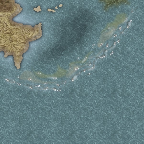
So, honest opinions on these two -- a glacier with icebergs and a reef, both from a much larger continental WIP. I'm pretty happy with the glacier, but not there yet with the reef. Again, it's a WIP so there's much left to do. So, opinions? Suggestions?


Comments
If you are open to suggestions about the reef, then I would say treat it as the land - make the water shallow around it in exactly the same way as you have with the land, rather than adding that yellow colour, which doesn't appear anywhere else and is sort of out of context because of that.
Basically - replace yellow with shallow - same effect as with the land.
Hope that makes sense!
I was thinking you could do the green of the algae around the rocks, but to make it look right with the rest of the map you would then have to start adding the dark shadow of seaweed to the rest of the shores - all the way around the entire land mass.
I know I did that with Scribble Rock, but that was just one really small island, not an entire continent!
Like so...
Tim
Sue, as for putting algae around the rocks and then around the rest of the coastline of the map... that is not unreasonable. I mean, if it takes time it takes time, I'm more concerned about getting it right and to look the best it can than the time involved. And your opinion does mean a lot to me as I, at least, DO think you are great!
You might have to scale it down quite a bit, and adjust the HSL, or even use an RGB matrix on it to change it to suit, but its yours if you want it
Personally, I think it would look better without any of that red (or green) stuff, but at least you have it for another map now
I forgot to warn you that the texture is a JPG to let me upload it here without any size issues (PNGs are bigger than JPGs)
You will need to open it in GIMP or a similar bitmap editor and export it as '[whateverfilenameyouchoose].png' before CC3 can 'see' it to use it as a texture.
Sorry Scott!
In regards of the reef: I tried to do reefs on the Maelstrom Bay Map. I think I basically used the technique Sue described. The map can be downloaded as fcw file, so you can see how I have done it.
Here's the same areas with more work -- still more to do. Better, but I'm not fully happy with either. Waffling over the whitecaps breaking on both the reef and the icebergs. Also not sure about the sand along the reef. Don't know if it makes it look too cluttered?
The reef looks great
The settlement would look a lot better if you took out that shadow effect. Actually, both maps seem to have this really fuzzy shadow effect on all the symbols. I don't think it works. Everything looks as if it is floating about 100 foot off the ground. Try turning it off and see how it looks without any shadows on the symbols. That's more of a dungeon map thing than an overland map thing
Well, the glacier is supposed to be at the most northern tip of a large (little smaller than North America) continent. I need the map to be self-contained, and not have the extreme north going off the top of the page into some vague, unseen polar region. I know many (most?) maps seem to do it that way with extreme north and south, but I need everything visible. Maybe the glacier just needs to be larger and run along the whole top of the map?