Saved Images Quality Sucks

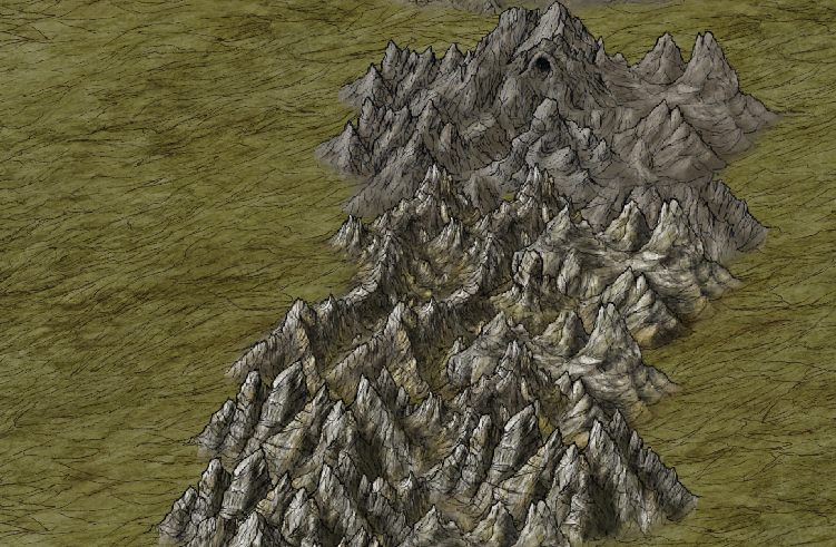
So, working on making a map and when ever I try to save the map to a png file, the quality seems to go downhill real bad. I've attached three images, one that is a screenshot of the cc3+ and pasted into paint, another that is the saved png image from cc3+ and a third that shows the saved settings I have used.

(Sharing as a imgur catalog as couldn't attach more then 1 picture.)

http://imgur.com/a/FWjAO

The map in cc3+ is suppose to be 1000x800

Comments

  • Have you done this:

    File>Save as>rename image
    then choose Rectangular PNG from the drop down
    click Options
    change Height and Width to 5000
    I use maximum compression (not sure if that's helping or not)
    and Quality at 75

    draw the rectangle on your map by clicking at top left corner of the image and drawing down to the bottom right corner then left click

    You can zoom in, of course, to any area before doing the above and only save that section out or just do the whole map


    My PNGs come out really good..almost too good, actually, as my latest map the text is supposed to be more jagged but my PNG viewer always smooths it out :S


    Cal
  • Okay, so that gave me a nice quality save, but the image is way to big for what I needed it for. Taking that into Photoshop and reducing the size just gets me back to poor quality.

    Using it it Fantasy Grounds, so was hoping to get the image with good quality at no bigger then 1400x1400 pixels. Was happy with the settings in CC3+ when I thought I was creating the map at the size of 1000x800 pixels, why do I need to save it 400% bigger to get that same quality as it has in CC3+?
  • I've been making mine for use in fantasy grounds and they come out great, save as - png bitmap - then go to options, I change settings to the biggest size, and make it 24 bit. It gives me a good picture thats large but not insanely large. Perfect for fantasy grounds.
  • Okay, so if the map I created had the size of 1000x800 when I clicked on New in CC3+, where is this biggest size you speak of and how do you figure it out? In the imgur link in my first post, I showed what I saved the file as. Basically using what you said but I think I used the maximum image size of 1000x800, which is what I thought I had created the image as, but it saved it with a white border and poor quality.
  • I only have a couple of options in the drop down menu... I picked the second one, and I dont change the actual size bit, just that drop down menu and the 24 bit thing.
  • They look like this in fantasy grounds fyi - (doing nothing other than what I said above)
  • MonsenMonsen Administrator 🖼️ 81 images Cartographer
    edited May 2017
    Posted By: DyaganUsing it it Fantasy Grounds, so was hoping to get the image with good quality at no bigger then 1400x1400 pixels.
    Images doesn't work like that, no matter what program you make them them in (CC3+, Photoshop, or anything else).
    Remember, a 1000x800 map in CC3+ is NOT the same as a 1000x800pixel image quality wise. The size in CC3+ is the size in map units (miles for overland maps, feet for dungeons/cities). CC3+ is a cad-based program, and doesn't use pixels for the internal representation of the drawing, pixels only come into account because it needs to render the drawing to screen or an image (and since symbols are image files that are placed into the drawing, they also have a pixel size, but that isn't really used by CC3+).
    Those mountain symbols in your map are actually around 500x500pixels each, so that CC3+ can give you a nice quality image when you zoom in on the map.

    If you want zoomable images (that still look good when zoomed), they will have to be large. 1400 by 1400 is ok for displaying fullscreen on a regular monitor, but not for zooming any more into the image than that. If you have seen the Community Atlas you can see that I have exported the high-res version of each map as 8192px along the largest dimension. This is needed to make them nice and zoomable as images (but they still have their limits). Of course, the actual size you need is strictly dependent on how zoomable you want them to be, but If you want to be able to zoom into the mountains in your image with that amount of details from the full map, the image will need to be pretty huge. But again, that is just how images work, the number of pixels in an image is strictly linked to the image quality. A CC3+ drawing is really a database of coordinates, allowing CC3+ to recalculate the view when zooming in, while an image only knows about the stored pixels. This is similar to how you can make a font any size you wish in your document in a word processor, and zoom in on it as much as you like, and it will never appear pixelated. Put a font in an image file however, and once you zoom in, it will appear pixelated.
  • Posted By: Monsen
    Posted By: DyaganUsing it it Fantasy Grounds, so was hoping to get the image with good quality at no bigger then 1400x1400 pixels.
    Images doesn't work like that, no matter what program you make them them in (CC3+, Photoshop, or anything else).
    Remember, a 1000x800 map in CC3+ is NOT the same as a 1000x800pixel image quality wise. The size in CC3+ is the size in map units (miles for overland maps, feet for dungeons/cities). CC3+ is a cad-based program, and doesn't use pixels for the internal representation of the drawing, pixels only come into account because it needs to render the drawing to screen or an image (and since symbols are image files that are placed into the drawing, they also have a pixel size, but that isn't really used by CC3+).
    Those mountain symbols in your map are actually around 500x500pixels each, so that CC3+ can give you a nice quality image when you zoom in on the map.

    If you want zoomable images (that still look good when zoomed), they will have to be large. 1400 by 1400 is ok for displaying fullscreen on a regular monitor, but not for zooming any more into the image than that. If you have seen theCommunity Atlasyou can see that I have exported the high-res version of each map as 8192px along the largest dimension. This is needed to make them nice and zoomable as images (but they still have their limits). Of course, the actual size you need is strictly dependent on how zoomable you want them to be, but If you want to be able to zoom into the mountains in your image with that amount of details from the full map, the image will need to be pretty huge. But again, that is just how images work, the number of pixels in an image is strictly linked to the image quality. A CC3+ drawing is really a database of coordinates, allowing CC3+ to recalculate the view when zooming in, while an image only knows about the stored pixels. This is similar to how you can make a font any size you wish in your document in a word processor, and zoom in on it as much as you like, and it will never appear pixelated. Put a font in an image file however, and once you zoom in, it will appear pixelated.
    Ah, thanks, this explains so much better. Now i understand, was thinking that the size in CC3+ was pixel based. Didn't realize those mountains were so large and such. Thanks, makes me less frustrated and give me ideal on how to get smaller more usable maps that still have decent size for FG.
Sign In or Register to comment.