

Community Atlas - Vyrn City
 HadrianVI
Surveyor
HadrianVI
Surveyor
Hi everyone,
here's a quick update on my Vyrn City project, which is going to be a larger project to test my limits.
Vyrn is the capital of the same named republic. The Republic of Vyrn is today the most progressive state in Berenur, both in a technological and in a political sense.
The city is by now also (most likely) the largest city on the continent, it's power is mostly built on it's commercial capabilities and it's fleet.
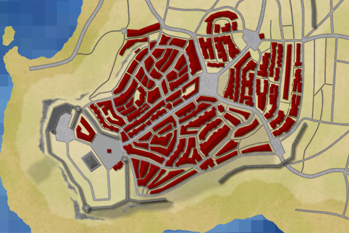
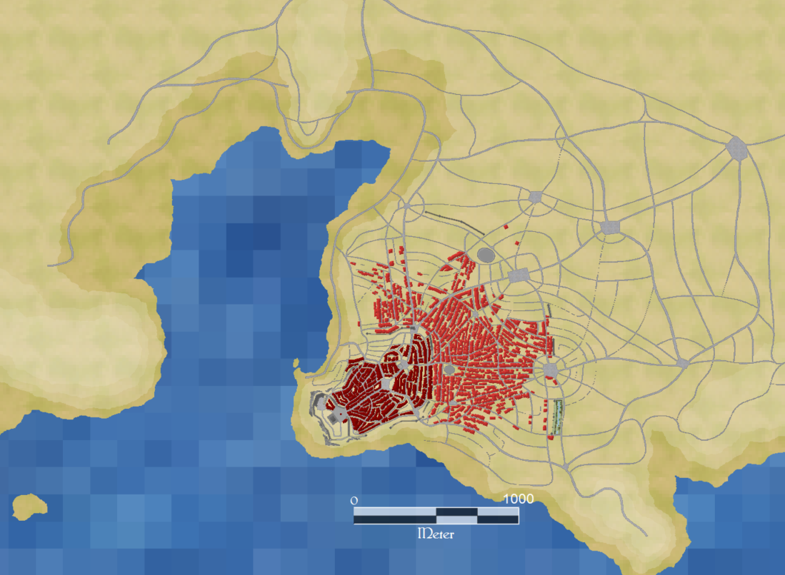
Because of the size of the city, mapping it will take weeks if not months. Here are two pictures of what I have so far. The first one is a close up look at the old town (I'm mapping according to the development of the city, starting with the oldest parts first). The other one is a zoomed out picture of the roads I have drawn so far.
As you see, I won't draw any individual houses, but just house blocks. Also, I do not use any of the house tools, instead I use a drawing tool similar to the one that comes with the "Fantasy Cities" Style from one of the first annuals. I would have used this style but it since it is not updated I used the Jon Roberts City template.
I hope you guys like it.
here's a quick update on my Vyrn City project, which is going to be a larger project to test my limits.
Vyrn is the capital of the same named republic. The Republic of Vyrn is today the most progressive state in Berenur, both in a technological and in a political sense.
The city is by now also (most likely) the largest city on the continent, it's power is mostly built on it's commercial capabilities and it's fleet.
Because of the size of the city, mapping it will take weeks if not months. Here are two pictures of what I have so far. The first one is a close up look at the old town (I'm mapping according to the development of the city, starting with the oldest parts first). The other one is a zoomed out picture of the roads I have drawn so far.
As you see, I won't draw any individual houses, but just house blocks. Also, I do not use any of the house tools, instead I use a drawing tool similar to the one that comes with the "Fantasy Cities" Style from one of the first annuals. I would have used this style but it since it is not updated I used the Jon Roberts City template.
I hope you guys like it.
Comments
I added the old harbor (which is just one of many harbors) and some districts to the north and to the east.
btw, the water looks very pixelated on my screen. everything else looks awesome
@RoyalWolf: Normally I don't get anything done during daytime, so I do most of the mappimg at night.:p
I maximized my efficency on this map by using a combination of different methods to draw the houses.
But the key to efficency is to use plain squares with a lighted bevel effect instead of house symbols.
Also, I'm aware that the background texture is quite a bit pixelated. I had to re-scale due to the huge map size amd didn't get it right at the first time. But since then, the pixels have actually proven quite useful as a sort of grid to align the docks.
But I will, of course, change the scale of the texture before finishing the map.
EDIT: i wanted to clarify...CITIES are my arch nemesis, CITIES. Not Hadrian! LOL
Thank you, Lorelei. I'm glad mot to be your nemesis.
As promised here's my newest update.
I added some of the city's defenses and the dock area on which I'm still working.
Here's another update on my Vyrn City map.
So far the "BLDNG City" sheet consists of over 18'000 entities. But there are still many free spots that need to be filled.
By now I begin to think that the project may have been a bit over ambitious.:P
The first map shows the entire city. The other maps show several areas more detailed. Keep in mind that I have not actually bothered with details yet.
The second one the old town and the harbor, the third one the hill on the eastern side of the city and the fourth one the Citadel on the western side of the city.
The fifth picture shows a part of the old city wall and the old ditch, which has now been turned into a small park.
I hope you like it.
@Lorelei: Thank you:) You're kindly invited to do floorplants of traverns, palaces, streets or what so ever, once it is finished:)
@Monsen: Thank you. Last time I checked the area of the landmass within the city walls a bit over 11 square kilometers (I use the metric system, because if I had to use feet, it would be impossible for me to keep a sense of how big things are.). This means it is a bit smaller than third century Rome. The Aurelian Walls enclose an area of about 13.7 square kilometers.
It is estimated that ancient Rome had a population between 230'000 and 1'000'000. But one has to consider that ancient Rome was pretty much a mess of houses with only a few larger roads. Therefore less space was taken up by Roads. Further, Rome did not have a that huge dockland area since it's large harbors were outside the city. At last, Rome's defences were not as sophisticated as the one Vyrn has. The Aurelian Wall was about 3.5 Meters thick, while the walls of Vyrn take up a lot more space. The population density of Rome must therefore have been higher than the one of Vyrn. However, Vyrn does not have a insanely large structure like the circus maximus, which basically covered the entire bottom of the valley between Palatin and Aventin.
Vyrn could also be compared to the old city of Venice, which extends over 7.06 square kilometers and is said to have had a population of 85'000-100'000 around 1300, which increased to about 140'000 right before the first outbreak of the plague/black death. Regarding the sturcture of the city, Vyrn and Venice are somewhat similar, since both have dockland areas. Vyrn does not have channels, but Venice does not have extensive city walls.
Considering that Vyrin is slightly smaller than ancient Rome and about one and a half time as big as the old city of Venice, I think a population of between 160'000 and 240'000 would be realistic. (But since this is a top down map, that does not show how many stories buildings have, there is room for interpretations. However, I would say that anything beyond 500'000 would be clearly exaggerated.)
@RoyalWolf: Thanks:)
I have one more continental size map to do, the underworld for Kumarikandam, and then I will start expanding my skill sets. I plan to do some cities, towns, caverns, buildings, and dungeons to name a few... I will try my hand and some new styles as well. :-)
In case of Vyrn this did not turn out to be a problem with the intended size of the city because the farmland area is quite huge (which also means that the Bay of Vyrn Region is most likely the most boring one in Berebur, at least landscape wise). But if I had made the city a lot bigger, I would have had to annex Charles' Port Digby and turn it into a Vyrnian Colony (with Charles permission of course). Then it would have served Vyrn the same way as the province 'Africa' served Rome:P But if I did the math correctly this won't be necessary with the current size of Vyrn.
@Charles: Thank you. You too are invited to practice your skills on Vyrnian floorplans ect.:)
I don't do evil invasions.;) I would have awaited the next public unrest, then send in the finest Vyrnian forces (of course without Vyrnian banners). And while everyone would have been wondering who these soldiers were, I would have gained control over all the strategic important positions. Then I would have cast a vote on whether Port Digby wanted to join the Republic of Vyrn, which would have turned out in my favor (the fact that Vyrn is a Republic does not mean that the powerful here actually care about the rule of law and this kind of things)... So one could not call that an evil invasion. :P
And Australia, which is not owned by another country, makes most of its export income from exporting food, wool and minerals to other countries - so no need to own the food supply. Rome's problems were because the invaders did not want to do trade with the Empire (especially in the case of Byzantium when it lost Egypt to the Muslims)
I hope you guys like it.
I'll take a couple of days off from mapping this city and will hopefully be back with a further developed version.
Thank you, Medio. I see what you mean. This will be done at a later. The map is still at a very early stage after all.