Halle

ClerconClercon Betatester Traveler
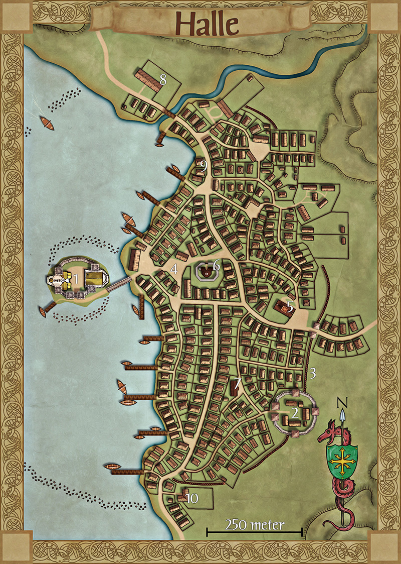
This is a map I've made for the erebaltor.se site. It is the capital of the viking inspired country named Jourdashur. The town is made in CD3 but all hills and the palisade are made in PS. I've also made the border and the compass rose.

Comments

  • KenGKenG Traveler
    This is really great. I really like the border.
  • I like the addition of the pallisades! But the neat street plan and low fences around the houses remind me more of a planned sub-urb than an organically grown settlement. But you can see which parts were built first, that's nice.
  • ClerconClercon Betatester Traveler
    Posted By: FubBut the neat street plan and low fences around the houses remind me more of a planned sub-urb than an organically grown settlement.
    I can agree a bit on this, but the actual city plan isn't mine. The map is made from a sketch I got when taking on the commission. Still I think the "Viking" way of building houses where you had a fence around your house garden strengthens that feeling.

    And thanks for the comments :)
  • DogtagDogtag Moderator, Betatester Traveler
    Looks fantastic. Any chance we can see the legend. I'm curious about #2.

    Also, what are the "dots" in the water, piles of some kind?

    I agree that it seems awfully... neat and organized for a viking village. I'll be the first to admit, however, that I've never seen a viking village so my opinion is based entirely on "feel" rather than any historical knowledge. But it's a wonderful-looking map. And I really like the subdued colors.

    Oh, and I really dig the small wake you added to the boat in the NW corner. Nice touch, that.

    ~Dogtag
  • ClerconClercon Betatester Traveler
    Thanks Dogtag. I'll try to add the legends later so you can see what the different numbers are. The dots in the water are a barrier consisting of tree trunks that are placed there to prohibit an attack from water. To reach the harbour you have to enter through the NW corner. And that place can easily be blocked through sinking a ship or two in that place.
  • DogtagDogtag Moderator, Betatester Traveler
    Cool. Thanks!

    ~Dogtag
  • Clercon, I think you're right about the small fences. It's traditional to do that -- especially in a village. In fact, the Dutch word for "garden" is "tuin", which is derived from the word for a low fence of woven willow branches, "tuun". (So it's not exclusively Viking!) And if the plots of land were sold/marked by someone (the land owner), then it is both planned and traditional.
    I think I would have made smaller groups of plots, though -- so that it would look like the village grew in little spurts. The many plots along the long north-south street seem to me like they would have been planned in one go. The plots to the east of that street have smaller 'clusters', which means the village grew little by little there. Of course, I know nothing of the background of the village of Halle, so maybe there's a reason for that.
    (Oh, and I really like the shadows you did for everything. Things like that don't register immediately, because it looks so natural. Great attention to detail, as usual!)

    I too had wondered about the dots in the water -- I had assumed they were rocks or something. Protecting the harbour by sinking a few boats in the small opening is traditional too. It's what they did in the harbour of Roskilde. Good thing they did, because now there's a great Viking boat museum there which I totally recommend if you're in the neighbourhood.
  • 6 days later
  • I really like knots border and this one is quite an advanced version and a great achievement, but so is the map itself :))
    Fantastic work, Clercon!
  • Henrie61Henrie61 Traveler
    I really like th overall look and feel of this map.
    If its the correct layout for a viking town, no idea, am by no means an expert in that area.
    But for me the layout of the town is a bit to neat to be a viking town.

    Love the border and the compass rose.
    Think the hills are well done too.
  • ClerconClercon Betatester Traveler
    Thanks for the comments everyone. The layout is probably too neat for a real Viking town, but I didn't do the layout, I worked from a sketch I got of the town.
  • The border is amazing Clercon, also amazing details such as the waves the boat makes in the northwestern part of the map.
  • ClerconClercon Betatester Traveler
    Thanks Moskva, the border is actually not too hard to do in Photoshop. I try to add a tutorial on how to do one on my blog (mappingworlds.wordpress.com) later for those interested.
  • Posted By: Clerconfor those interested.
    I definitely am!
  • 28 days later
  • ClerconClercon Betatester Traveler
    Joachim de Ravenbel, and other interested. I´ve now added a tutorial on my blog on how I make my borders in photoshop
  • Posted By: ClerconI try to add a tutorial on how to do one on my blog
    That would be nice, I really dont have a clue on how to make a border like that.
  • ClerconClercon Betatester Traveler
    Moskva, check my latest post and you'll see that I've just written the post.
  • Posted By: ClerconJoachim de Ravenbel, and other interested. I´ve now added a tutorial on my blog on how I make mybordersin photoshop
    Thanks a lot :))
  • Posted By: ClerconMoskva, check my latest post and you'll see that I've just written the post.
    Still looks easier than it really is. But I'm not quite proficient at using photoshop, thanks a lot for the tutorial! I really appreciate it.
Sign In or Register to comment.