

Is CC3 right for my project?

I am wondering if CC3 is right for a series of projects I will be working on. I need to create historical and historical plausible maps. I have two main questions:
1. I need to be able to print these maps large, upto 4x8 feet. Can CC3 handle or produce the required resolution to print something that large and still look as good as it does on the screen?
1a. If it can print at that size, would I have to draw the map in 1 to 1 scale, or can the program upscale the final map to the required output size?
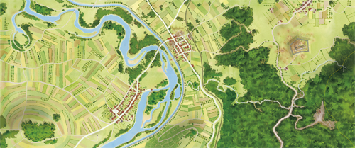
2. Out of the box, or with a current plugin/mod, can CC3 produce a style similar to these:
Thank you for your time and help,
Keith
1. I need to be able to print these maps large, upto 4x8 feet. Can CC3 handle or produce the required resolution to print something that large and still look as good as it does on the screen?
1a. If it can print at that size, would I have to draw the map in 1 to 1 scale, or can the program upscale the final map to the required output size?
2. Out of the box, or with a current plugin/mod, can CC3 produce a style similar to these:
Thank you for your time and help,
Keith
Comments
Can CC3 produce a map in the slyle you want? Problably yes.
But as far as I know the style isn't available out of the box.
And remember. CC3 can produce great maps, but like any tool it also requires patience and practice.
If you want to go through with this I suggest you make smaller maps first before starting a project like this.
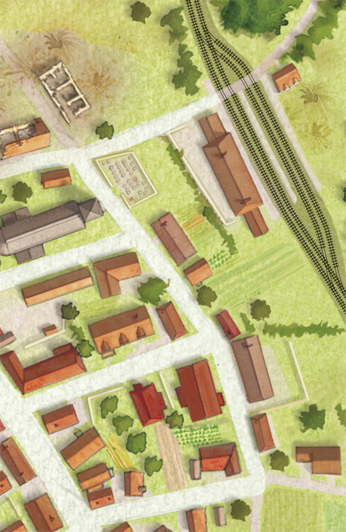
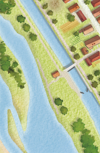
The style of your sample map is very nice (where is it from?).
Take a look at a CD3 map in this pdf.
Or one done by Pär Lindström (forum name Clercon):
http://forum.profantasy.com/extensions/InlineImages/image.php?AttachmentID=1742
You can laminate the map sections (each section) onto divided wood or MDF board sections - or just glue them to posterboard, foamcore, or card board 1 x 1 sections - that way the map is divided into stackable sections for ease of storage and increased longevity. personally - I would have them professionally laminated to 3/8 thick wood plaque boarding (ash or cedar).
There are actually portable model railroad layouts that store and assemble that way. It's also a pretty common method of building battle tables for folks who are into the WARHAMMER / WARHAMMER 40K fantasy / sci fi tactical wargames using physical models and miniatures.
If it's meant to be one big wall or table map on a single surface - then it's ok because the basic principle is still the same. I am operating on the assumption that you are wanting this map for strategic / tactical table top wargaming.
If you were to recreate this map in CC3 so that you were creating 1 x 1 maps that are INDIVIDUAL MAPS that are designed to fit together ultimately like puzzle pieces - then resolution shouldn't be that big of a deal (I wouldn't think) - it would only be iffy - resolution wise - if you were attempting to design one big "lump sum" 4 x 8 map to print and plop down. From what I know, CC3 can do extremly detailed and clean maps at a resolution sufficient for 1 x 1 maps. Just make 32, 1 x 1 maps that are designed to fit together - like Ralf initially suggested / implied.:
Doing this would require that I could export the files into a format that would allow me to maintain the high pringting resolution. What formats can CC3 output to and at what resolutions?
The images I posted in the first post are high res scans of watercolor paintings. The artist scanned them into his computer and is building a map that way. I want to do something similar, but thought CC3 might be a better way to go. The PDF that Ralf linked to looks pretty good, is that a standard style? I do like the Jon Roberts Cities style that is displayed on the home page quite a bit. I noticed that you could get that style as one of the subscriptions. Maybe that might be a way to go.
I did play around with CC about 7-8 years ago, but have no idea if it's easier to use and create maps with these days. I do recall there being a lot of trial and error to learn to setup the maps right.
I think CC3 is much easier to use.
bmp, png and jpg. Resolutions are memory bound (and CC3 is a 32-bit program, so it can only utilize 2GB of memory), so the dimensions Ralf mentioned (10000 x 10000) is at the limit of what you can do (and a very detailed and/or effects-heavy map will be less than that)
It is one of the standard city styles from the City Designer 3 add-on.
Many enhancements make it a lot easier to use than CC2, but it is still based on the same CAD engine (although a newer version), so the way of doing things are basically the same. IMHO it is way easier to use than for example Photoshop, which is one of the few computer programs I find really difficult to use. (Not that CC3 and Photoshop are really comparable, because they work in completely different ways)
The DXF and DWG formats are interesting as they can be imported into Adobe Illustrator. But PNG should work just as well.
A couple more questions if that is okay...
Looking at this more, what I'd really be doing is making one large city map with CD3, with just lots of "rural" area on the map. Is that about right?
If file sizes start to become an issue (not expecting many effects, just a global lighting/shadow I think), is it possible to create the background part of the map (ground and trees) as one map, and then create all of the towns/cities (houses, train tracks, roads) on a separate map with out a background or a transparent one (via PNG)? If that can be done, I could easily add the town/city map onto the background map in PS or AI. For that matter, each town/city could be done separately and added in that way.
Note that the DXF/DWG format exports does not support all the features in the map, so they are not a good export format at all for a finished map. They are more of a special-case use. I would say so. You should be able to make the map without CD3, but from the example maps you posted, if you are aiming to make something similar to them, then you will benefit from the house tool in CD3. Technically, that should work. Note that CC3 doesn't add transparency to it's png export, but as long as you use a color not present in the map as a background color, and do a non-antialiased export, it is easy to turn that color transparent. No need to worry about that though, file sizes are almost never a problem in CC3, unless you go crazy with the fractalization tool (Which I don't think will be needed for this map, that is more of a coastline thing). If you need to however, both layers and sheets can be hidden in a map before export, allowing you to hide and show map elements at will. You may wish to try such tricks if your map gets to complex for the export size you desire however.
Last questions ( I think, lol). Can CD3 be used as a standalone product, or does it require CC3 first? I think it does, just want to make sure.
Thanks again everyone for all the help. It appears that this is a strong community of users... always a plus!