

change all units to european styles

Hello just purchased the application CC3 and went through the video tuturial for overland map. i have a question though.
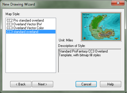
For example if i choose any of the map styles the unit is always displayed in miles can i change that somehow so it always is in the european way (kilometers instead of miles)
please look at the attachment and you will see what i mean, (if i did correctly)
For example if i choose any of the map styles the unit is always displayed in miles can i change that somehow so it always is in the european way (kilometers instead of miles)
please look at the attachment and you will see what i mean, (if i did correctly)
Comments
I would be highly appreciate having all templates available as metric also.
Qouting the Wikipedia Article:
"The metric system is an international decimalised system of measurement. France was first to adopt it in 1799 and it is now the basic system of measurement used in almost every country in the world; the United States being the only industrialised country yet to adopt the International System of Units as its predominant system of measurement. Although the originators intended to devise a system that was equally accessible to all, it proved necessary to use prototype units under the custody of government or other approved authorities as standards. Until 1875, control of the prototype units of measure were maintained by the French Government when it passed to an inter-governmental organisation - the Conférence générale des poids et mesures (CGPM). It is now hoped that the last of these prototypes can be retired by 2015."
Use of the Metric system is a fairly recent developement historically, and is more suited to contemporary genres. The Wikipedia article however needs correcting to the extent that BOTH systems are used in the U.K., the U.S.A., and several other countries. The metric system itself is under revision - as the traditional metric units of value are being replaced by the "SI" metric standards - which are based upon scientifically derived real physical values of time, weight, mass, force, liquid volume, and length - as opposed to invented values based solely upon subjective unit divisions for purposes of convenience. In short - to a certain extent - the traditional metric system itself is being replaced. For example - the second is no longer defined as merely 1/60th of a minute - but instead is now defined thusly according to the 13th CGPM conference (1967):
"The second is the duration of 9 192 631 770 periods of the radiation corresponding to the transition between the two hyperfine levels of the ground state of the cesium 133 atom."
Being an American myself - I can tell you that the reason why we still use the English system is because for us - it's more intuitive and instinctive. It's analagous in a way to instinctively speaking English instead of French, it's more natural to us. We use the metric system for precise measurement - but we use the english system for everyday common purposes where precise scientific values are not germainly crucial. Since it's not an impossible - but rather simple task to convert between the two - we currently really see no pressing need to abandon it, simply because a lot of other people have.
that said is it possible to change the scale bar (i think it is called) to for example days walk (being the amount of distans a person can walk in a day) as i mostly use that kind of thing to the players anyway. i can get around the mile thing when i design the map
(i have just begun with the manual and the video tutorial so i am fresh out of the box so to speak)
For the historical aspect:
In some parts / eras of ancient India and China decimal system were in use. The ancient Roman pes (foot) was divided in 16 digiti (fingers) not in 12 inches...
And in Medieval Europe units meant something slightly different every other territory. In my fantasy world this is also the case, for which reason I reference those units to the metric system.
Sorry for the thread-napping. There is an option to change the units to metric after you have finished the drawing wizard. Its part of the drawing properties (menu: Files\drawing properties).
HMMmmmmm...Well now...I don't know about within what context that you were referring to the U.S. as being a "small market", honestly we're probably the largest importers and consumers of European and Asian goods in the entire world - but I digress. ANYWAY - I'm not sure about changing the scale bar because I haven't been working with CC3 all that much - and I do need to since I'll probably be doing some symbols for it eventually. The manual / help files should cover it - or Ralf might know. I would think that there is a graphics option that naturally should allow you to change the bar to represent just about anything that you want it to.
Ok - average human walking speed is 4 mph (6.437 kmph) - maximum hours walking per day (minus 8 hours for sleep) is 15.6 hours.
6.437 x 15.6 = 100.42 km per day on foot.
Your bar would be divided into increments of 100.42 km, One days walk will cover a distance of 100.42 km, or 62.4 miles. Rounding off - every 100 km on your map represents one day's journey on foot.
If you want to count "pee pee / poo poo" breaks and snack time - then your looking at just around 12 hours travel time per day - re-adjusting:
6.437 x 12 = 77.2 km per day, or roughly 48 miles.
Depending on whether you bring your food and water with you or you have to do a bit of hunting / fishing / gathering - if your regular or constipated - and if whether or not your a lite sleeper - your mileage may vary.
the remark with "small" was a quite bad joke sorry i doo know that the US is the biggest market in the world.
i meant this scale bar (see picture)
Using this in a realistic sense - it is 957.86 miles from Dayton Ohio to Orlando Florida, or 1541.5262 kilometers. This would represent 19.967 - or 20 days journey on foot, or roughly three weeks walking time. In other words - to walk from Dayton Ohio to Orlando Florida would take just under a month. If you don't want to count Breaks - then each bar would be 2 x 77.2 = 154.4 km covered per 24 hour period. In that case a trip to Florida would only take around 10 days, and then you would collapse at the gates of the Magic Kingdom.
By the way - It's ok - I'm not at all perturbed with you. I'm just a little grumpy because of the whole mid life crisis thing, Lol.
A Roman legionary was expected to cover 30km (48,27 statute miles) a day, although forced marches of 50 km per day and more are recorded. And they did so mainly on the Roman roads. And even if you take into account that they had to brake camp, form marching columns and built another camp at dawn, you also have to remember that they spent quite a lot of time training their marching formation and speed during basic training.
In the Middle Ages average travel speeds of itinerant kings were 25km per day.
@merak43:
As for changing the scale bar. Mine comes without the text, so the labelling may have been done by the drawing wizard (didn't check up on that). Accordingly the easiest way to change the labelling would be to erase the scale bar and insert one without text. Then label it with the text command according to your likes. There might be another option within the drawing wizard or using the change properties command, didn't check up on that either
Also - 30km is 18.6 miles, NOT 48 miles. That means that if they covered 18.6 miles in 12 hours, they would have to be doing 1.5 mph - which is a lazy, pokey stroll, not tiring at all unless your carrieing 70 lbs. of gear with you. If you were expected to walk that pace with nothing - it would be an easy cruise.
50km is still just 31.1 miles. Back then - a walk of 31 miles per day would be about common, even for a twelve year old running errands for his grandmother, or for mom to cart back groceries in a basket on top of her head, or a nap sack on her back from the street market in the big city - to her little village.
Remember that back then they didn't have cars or even bicycles, and carts and horses were very expensive - usually if somebody had a wagon, they built it themselves or it was a "hand me down" - and even then it was typically pulled by a single, overused - broken down farm horse, a donkey, or even a cow. It wouldn't even be unusual to see small carts pulled by goats. Transportation was not a finely tuned - readily available technology.
Most people walked EVERYWHERE back then. They were a lot tougher and much more rugged than we are today. What they did in their everyday "ho-hum" routine - would have even physically fit people today crying like babies with aching joints, burning feet, battered backs, and broken spirits. They did more labor in a single day than most of us do in a week. They went to bed at sunset - and got up when the rooster crowed and the stars were still out - and 90% of their waking day was pure toil. Back that up with the fact they they hardly ever bathed, they did not have indoor plumbing or running water, and a refridgerator or microwave oven were at that time inconcievable - and you get real impressed.
I currently live in the Eastern part of the U.S., and trust me - I am almost tempted at this point to try to march west of the Rockies out of desperation! Lol
P.S. - "Itinerant Kings" probably spent some time doing other things besides travelling on lo' their many Journeys, hence the circumstantial deflowering of a village daughter, the odd pheasant hunt, and the occasional tent lounging and mead sipping sessions - not to mention the odd nap - with a likely mention to "Wake me when the fighting commences", lol.
Internally, the program uses a scale of "map units". Miles, KM, inches, light years, etc. are just labels we give to the map units as appropriate for the map. So even if the new map wizard says the scale is miles, simply ignoring this and assuming it is kilometers (or anything else) won't cause any problems. The only real issue is the text on the scale bar you posted, which read "scale in miles". To change this, first use the EXPLODE command on the symbol. This breaks the symbol into it's individual components. You can now use numeric edit (EDIT) on the text (remember text is selected by clicking on it's baseline), and change the text into whatever you need.
For floor plan maps, it becomes a bit more important if the map was designed for metric or imperial units, as this impacts symbol scale, but for overland maps, it makes no difference at all. Simply treat map units as whatever unit you need.
sorry for all the stupid questions
If you wish to get rid of the references in your map, you can open the fill style dialog, and just delete the problematic fill styles from the "Bitmap Files" tab. Note that this will only remove them from the current map. To remove them from the template, you need to open the template file (.fct files) and do the same with those. Note that template files can be opened just as regular maps.