

2 Questions - Importing PNG and Tracing an FT Map
 rdyornot
Newcomer
rdyornot
Newcomer
Hiya!
New to CC3 and I have two questions
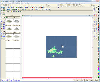
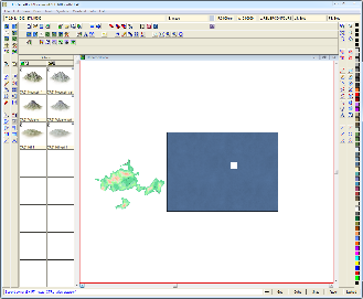
I'm trying to import a PNG from fractal terrains and i'm having a rather odd problem - i import the image, set the origin to 0,0 - then i scale the image beyond a certain point, it flips over! I'll include screen shots to it's a bit more clear. The white dot is supposed to be my mouse.
edit: I also tried typing in the coordinates with the same result.
My second question - when I try to trace the map (the same one in the images below) I invariably get slashes across the image. I read that this is caused by an inappropriately placed node - but how can I tell which one (there are far too many for just trial and error), or how should I be tracing to avoid this altogether?
Thanks :-)
RC
New to CC3 and I have two questions
I'm trying to import a PNG from fractal terrains and i'm having a rather odd problem - i import the image, set the origin to 0,0 - then i scale the image beyond a certain point, it flips over! I'll include screen shots to it's a bit more clear. The white dot is supposed to be my mouse.
edit: I also tried typing in the coordinates with the same result.
My second question - when I try to trace the map (the same one in the images below) I invariably get slashes across the image. I read that this is caused by an inappropriately placed node - but how can I tell which one (there are far too many for just trial and error), or how should I be tracing to avoid this altogether?
Thanks :-)
RC
Comments
As for the trace nodes, I zoom in and click every few points. Hard for me to describe.
I follow the basic outline of the coast. I don't try to be exact. Gives me a headache. Other folks here have an easier time doing that. My 'follow the basic outline' gives me areas that fit what I'm looking for in a map. What you do is up to you.
Hmm... Do you have a map border on your map ?
I found a work around for the first problem - i import the file as a small image, then use the scale command - this works, but I'd still like to know why the problem occurs, if anyone knows.