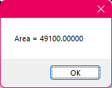
Add or remove precise amounts with drawtool "edit" function?
So as the title says, I want to know if this is possible. The reason is: a couple years ago, after some edits, one province on my modern country map ended up - purely by chance - with this area:
A flat 49,100 EXACTLY. I couldn't believe it, lol. I've never created a landmass (or a fractal entity of any kind, really) in CC3 and had it be a whole number, let alone also having 0 for the ones and tens places!
A friend and I joked "never edit that province again!" Well... I might need to do some edits to it, sadly, to accommodate some new ideas. So what I want to know is: is there any way to use the drawtool "edit" function to make changes, but specify how MUCH is added or taken away? i.e. if I make my necessary edits, and then the area has changed to say, 49,102.87... would there be some way to activate "edit" again and just shave off exactly 2.87, to get it back down to 49,100?
(Specifically in this case, it's the "Land, default" drawtool of the "Modern Political" annual style, which creates a closed fractal polygon with a blue outline for the coast.)
This obviously is not super critical, but the fact that it accidentally/unintentionally ended up with that area is just a cool thing that I'd like to preserve if I can!


Comments
No, there is no way to specify that. My approach would be to use the node edit tools instead. Now, you can't do this with them either, but you can easily calculate node positions to make this possible.
This is based on the fact that if you add a new node between two nodes, you are basically adding a triangle to the landmass, defined by the lines between the two old nodes and the new one. And the size of said triangle depends on the position of the new node, and can be calculated doing a bit of trigonometry.
Same if you remove a node, you are basically removing a triangle from the landmass (or adding one actually, if you are adding or deleting a triangle to the total depends both on if the angle is acute or obtuse, as well as if you are adding or removing a node).
Thanks for the reply as always Monsen!
Not too surprised the drawtool edit can't do this, but figured it was worth asking in case I had missed the option somehow.
As for node edit, that's... some math, lol. Was never great at it and it's been a loooong time since geometry or trigonometry classes, haha. But I'll play around with it, see if I get my head around how to use that tool.
Failing that, I can always keep making very tiny manual adjustments with drawtool edit until it gets back to what I want, or at least pretty close. This is tedious of course, but should more or less work. I'm not 100% sure I'll be editing this province anyway, it's just one of several possibilities at the moment, so this might be moot, but we'll see.
Instead of editing the land mass. Add a second sheet with all the same effects and fills. Then use little tiny multipoly's to accomplish it.
Sure it's cheating, but trying to subtract and add volume to something down 5 decimal places of order is outrageous. The level of zoom in to do this surgery would be mind numbing.
But if you really wanted to do this, I'd cheat and use squared off areas, because the math would be much easier. (this is for the really low decimal places where it would never be detectable by any zoom, unless you knew exactly where to look.) You could make copies of each and add and subtract as you like.
This whole post makes me not to even want to imagine the work behind attaining this.
Don't forget to keep a separate copy of your original map file too - let's face it, you'll never be that precise by-chance again! - and it's handy in case you end up with something you're less happy with after making some adjustments to it.