

[WIP] Adnati - Birdseye Continental
 Royal Scribe
🖼️ 388 images Mapmaker
Royal Scribe
🖼️ 388 images Mapmaker
I decided with this one to create JPGs of every step of the way to document the process. I'm only one step two (rivers) and I am already seeking input from the Cartography Hive Mind.
I decided to copy my land over from when I had rendered it in the Fractal Parchment World style last month. That style has the rivers as a cutout, but because Birdseye Continental has the rivers on the same sheet as the oceans, they both have a similar effect in that you can overdraw the rivers past the coastline without it looking funny.
But first I made a copy of that FCW, simplifying it by removing unused sheets and layers, changing the fills to solid colors instead of fills, and then deleting all of the fills. That way when I copy the landmass into new FCW files, it minimizes what it brings in and I won't have a lot of extraneous or confusing fills and sheets and layers that I won't need or want.
Here's what that simplified map looks like:
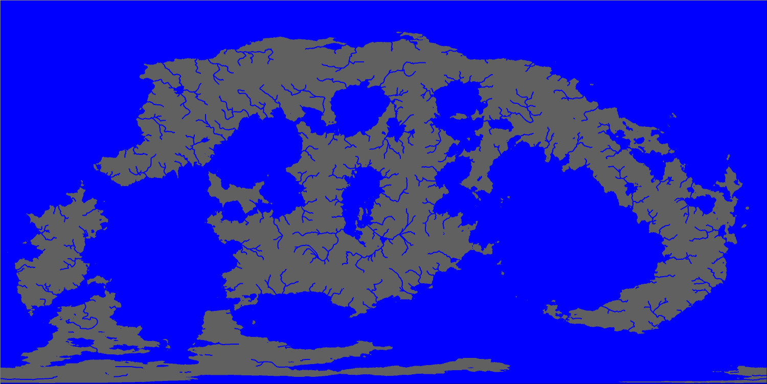
So I created my new Birdseye Continental map at around 6,000 x 4,000 miles, changed the map size to be 24,960 x 12,495 miles, added the Sea over the green land, and then copied over the land mass from my little template. Changed my land to be a magenta cutout on the Waters (All) sheet. So far, so good.

Then I copied in the rivers and used the Change Like Draw Tool function to change the rivers to the Birdseye Continental style. And that brings up my aesthetic question for all y'all. The rivers in Fractal Parchment Worlds have a default width of 24. (!!!) The default width in Birdseye is 3.
To my mind, 24 is too wide for this map, but what do you think about how 3 looks? Should I bump it up a little or leave as is -- or even delete rivers that would be too small to represent on a 25,000 mile wide map?
For perspective, there is only one river in our world that gets up to 24 miles wide (the Amazon), and only eight that are three or more miles wide: Congo (15), Yangtze (8), Mississippi (7), Paraná (6), Mekong (5), Brahmaputra (4), and Ganges (3).
I know this is supposed to only be the major rivers, and having this many rivers that are 3+ miles wide is rather pushing it. Even so, I'm thinking about (a) leaving them all in, and (b) keeping most of them at 3, while bumping up a few of the really major rivers of this world, but I am very open to everyone's thoughts. I will add this last map to my galleries if you want to be able to zoom in a bit.

Comments
It depends on 2 things. How large you intend to use this map, and whether it's practical to scale the river width up when there are so many of them.
For instance, if you want to have it as a large export that is 10,000 pixels on the long side you can get away with more rivers of a slightly wider line, but if you only want it to be 5,000 on the long side when exported, it might be less crowded with rivers if you delete the tributaries and just have the main rivers fractionally larger.
Best thing to do is to export it at the size you intend to use it right now and look at the rivers - see if they are a) visible, and b) cluttering up the map too much, or just about right.
This is also a good time to make sure they all reach either the coast or a very large lake/inland sea.
This is also a good time to make sure they all reach either the coast or a very large lake/inland sea.
Oh, yes, that’s why I used my Fractal Parchment map instead of a fresh FT export. I had already done all that work for the parchment map so no need to redo all that with a fresh export.
I hadn’t really thought about the export size. I will experiment. Good advice! Thank you.
I think it looks good. Proportions wise.
How I tend to think is fractal. When you zoom in each new map. Huge rivers become rivers and then streams and then creeks. So as long as zoom level has the same proportions then all is good.
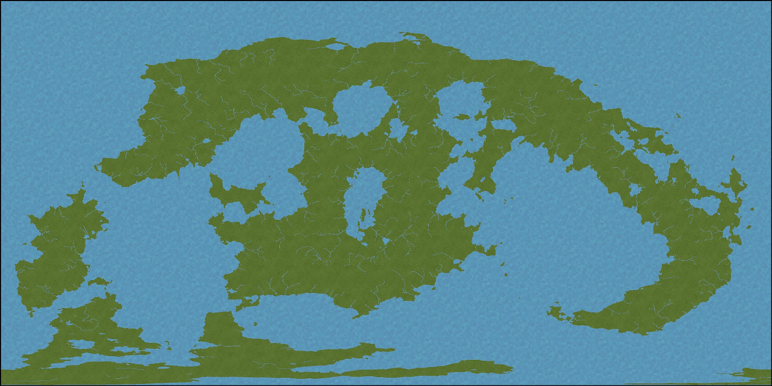
Okay, here's the progress I've made so far.
After lots of experimentation, I ended up going with a default width of 6 for the rivers.
Then I added a grid brought in from Fractal Terrains to show the major latitude lines. This shows the equatorial line in the middle, with +/- 30 degrees latitude for the lines above and below the equator, and then +/- 60 degrees latitude for the top and bottom lines.
For context, cities like Cairo, Egypt and Austin, Texas are at the 30 degree latitude. Helsinki, Finland is at the 60 degree latitude. If anyone is interested, I once compiled an Excel spreadsheet of the longitudes and latitudes of major cities in the real world to give me some context for weather patterns and biomes for places in my campaign world.
Next, I drew in some lighter grass areas inland, leaving the darker green more to the coasts. (A little sloppy, but we still have mountains coming.) And I added snow to the equivalent of the Antarctic region, and a little bit of tundra.
After that, I added some icebergs in the polar oceans.
Then I added some contours to the oceans.
Here's the first step at creating mountains. I copied in a higher elevation contour from a Jerion-style export from FT, and then used Change Properties to change it to the Alpine terrain, placing it on the appropriate sheet and layer. Fortunately, I made a backup of my FCW file, which was good because I didn't like my first attempt and tried again with an even higher elevation. I also used the Explode "Straight to Smooth" option to smooth it out a little.
Then an even higher elevation for the Scorched Alpine.
And then copied in one very high elevation. I changed this to the Light Tundra terrain but created a TERRAIN TUNDRA LIGHT 2 sheet for it, where I could lighten it a bit. (Accidentally lightened it on the non-alpine bits on the lower left continent as well, but that gets fixed later.)
I added some snowy ridges and ripples to the alpine tundra areas, and then drew in a tight field of snow around them. These are the highest mountains in the world.
Finally (so far), I added more snow in the very north, more tundra in the northern and southern areas, a prominent desert area (my world's equivalent of the Saudi Arabian peninsula), and more of the lighter grass.
Much more to come. Still have to add lots more (non-snowy) mountain ridges and ripples, hills and uneven terrain, forests, and other natural features.
Looking good so far :)
Only thing I would add would be a fancy, or Red equator line. That is just my personal preference.
Otherwise it's looking nice, thanks for sharing.
But I do see a baby elephant, not gonna lie.
That central donut shaped continent looked to me like a sloth hanging from a tree, but a friend of mine thought it was a smiling frog. It’s like a Rorschach test.
Okay, here's the next iteration. I removed the snowcapped mountain ridges and replaced them with larger ones, and then added ridges and ripples to the other mountain ranges. Added some vegetation but more to come, along with other sorts of terrain. I have a feeling that this map will be constantly tweaked as I dive in deeper to various areas and decide what goes there. Of course, tons of things wouldn't register on a map of this scale, like a swamp that's only a few miles across.
I'm wondering if it would be better to have wider edge fade inner effects on a map of this scale - to blend the biomes into each other.
I’ll experiment. Thank you for the suggestion.
Widened the edge fade on most of the terrains -- considerably wider on the grassy ones, less so on some of the others.
Starting to add more forests and farmland. Also need to add more natural features like volcanos and cliffs.
Looks better now the grass is more blended :)
Agreed! Thank you for the suggestion. And once I add more vegetation and other features, there won't be so many large stretches of the grass.
This may do, for now. I'm hesitant to add too many features until I have a better idea of what's happening in different parts of the world (though a lot of that would be too granular to appear on a map of this size, and I can always continue to iterate this map as things develop).