

[WIP] - Lumadair: Birdseye Continental
 Royal Scribe
🖼️ 388 images Mapmaker
Royal Scribe
🖼️ 388 images Mapmaker
Before attempting to do my entire Earth-sized world in the new Birdseye Continental style, I wanted to practice on a smaller bit of land, the tried-and-true Republic of Lumadair. I find it helpful to have the exact same FT export used for so many different styles -- I can toggle through JPGs of all of them while the coastlines remain identical, for better comparison.
I won't have time to do more work on it for several more hours (it's the start of my workday here on the Pacific coast), but I figured in the meantime I would seek feedback on my progress so far.
First, for perspective: Lumadair is in an equatorial climate. Very equatorial. Fractal Terrains tells me that the equator runs right through the middle of it. The latitude runs from -10 degrees on the southern side to +10 degrees on the northern side. Here it is circled on a map of my campaign world:
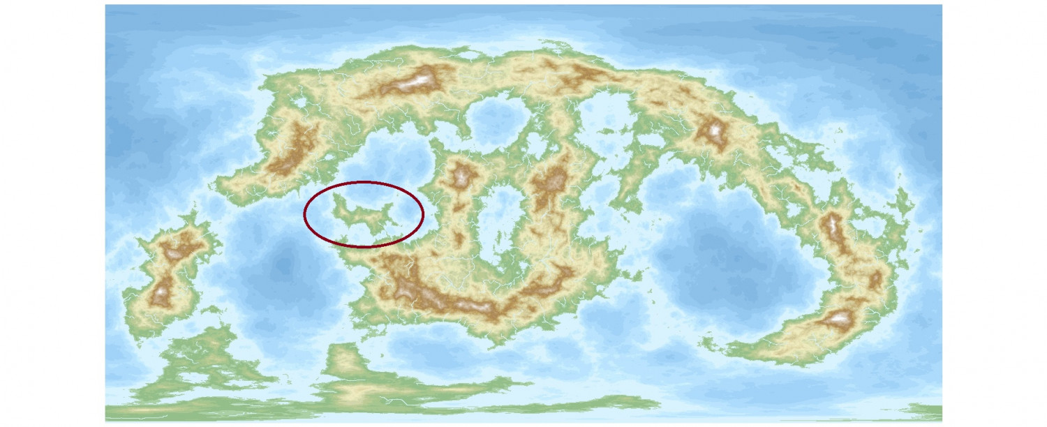
(After doing some terraforming to turn some landlocked great lakes into seas connected to the oceans, I made some adjustments to how it's viewed. I discovered that rotating the longitude perspective by 90 degrees allowed the main landmasses to all appear on the map without wrapping around. And I flipped it because I liked how it looked better that way, so FT will tell you that the top of the map has negative latitude numbers, with positive ones on the bottom half, but since that's not displayed, it's easy enough for me to mentally adjust.)
There are more images of Lumadair in my galleries if you want to see the terrain and symbols in other formats.
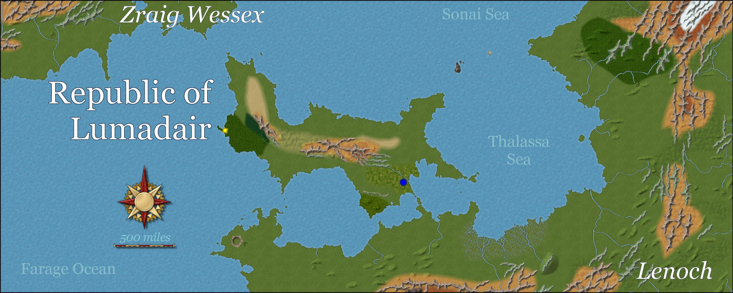
Here is Lumadair so far in Birdseye Continental. Haven't drawn most of the forests yet, nor water depths. I want to redo all of the mountain ridges and ripples to make them fit together a little better, and also be slightly less linear, even though they should still more or less be going in the same direction.
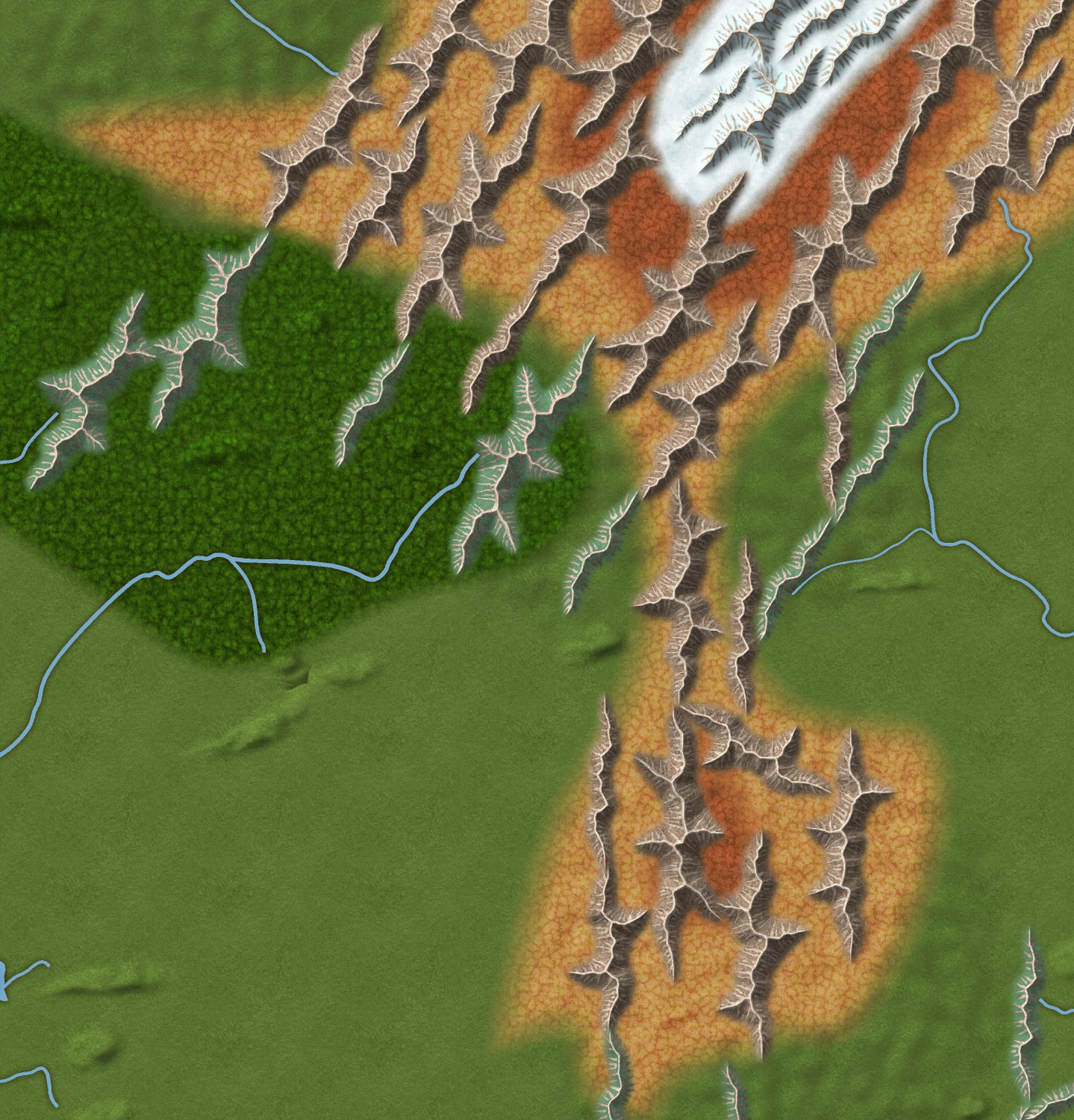
Here are the mountains in northeast corner up close. I tried to use varicolor green ridges to show lower mountains covered with trees, but I'm not sure how well that worked. I might experiment with adding a chameleon or drawn hill beneath them to give them more height. The snowy part is for a mountain that is so high that it is perpetually snow-covered. I think it's the third highest on my campaign world? I think the highest is about 30,000 feet and this one is around 25,000 feet. But I think I want to adjust the snow terrain to be a little tighter to the snowcapped ridges. Thoughts?
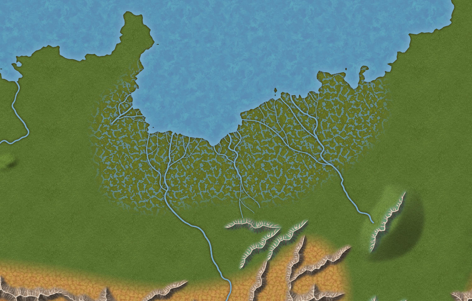
I do like how the swamp turned out. The main rivers have a default width of 3, but I added more branches with widths of 2 and 1. (This swamp map also shows an experimentation of putting a ridge on a chameleon hill.)


Comments
I would agree with you that the snow should be tighter to the caps.
One thing I would think about is that it is unlikely to go from snow to dark brown. That snow melts so there will be water trickling down. I am not saying it should be lush green, but it dark brown does not look right to me.
Thank you, Julian. Is the lighter brown okay, or should I maybe put a tundra fill in between the snow and the brown?
Reworking the mountains, replacing all of the ridges and ripples so they flow together better to my eye.
Here are a few different tweaks. Thoughts?
Version 1
For the snow-capped mountain, I replaced the scorched alpine fill with a tundra fill, and redrew the snow to be tighter around the snowy ridges. Also added an ice fill between the ridges. I should probably add some ripples onto the tundra terrain but should they be snowy or arid?
Version 2
All of the changes in #1, but I drew a hill polygon around the mountain. Not so sure about this one.
Version 3
All of the changes in #1, without the hill in #2, but I lightened the tundra using ADJUST HUE/SATURATION effect (Lightness +50%)
Version 4
Same as #3, but I added the Uneven Ground texture over the mountain.
I don't think the hill poly works in that context very well. It was set up to be home to small smooth shapes about the size of the chameleon hills. The other options are down to personal taste. Feel free to experiment.
The swamp looks amazing
I agree, Sue, about the hill polygon. It was worth a shot, but I think the Uneven Ground works better. I also added a bit of Rocky Waste around the edges of the mountains. I will try different approaches on the other mountainous areas to experiment.
Thank you, Don, I love the swamp. This swamp terrain is my favorite swamp fill of all the annuals.
Don't forget that you have two grades of grassland to play with to lend the illusion of altitude contours. The dark green grass you have everywhere is mostly for the lush lowland valleys.
Yup, yup! On my list to use, along with the drier plains (though since this is a tropical area, the plains will be minimal here, but more prevalent in the global map).
I like the hill underneath, but agree with Sue it might not be best here. I think I would go with 4.
How are you getting the water to show in the volcano? My version doesn't have that.
hmmm
Cal
Oh, and definitely #4 😁
It's one of the volcano collection.
Added some more. Only put in Lumadair's capital city and a few notable landmarks, not the other cities that were in previous versions of this map. Do you think the font size for my labels for cities/landmarks is too small?
I'm glad Sue chose to use a default font that can do accent marks because when I do the global map, there are a lot of accent marks. Mostly in names derived from Elvish, because Elves are fancy that way, like the French.
This map is 6,109 miles wide. I used the technique that Ralf showed of creating a 1000 x 800 map so that symbols would default to the scale of 1, and then resized it. I assume I should do the same when I start my global map, which is 25,000 miles wide.
Great first map in the style :)
I wouldn't use the same symbol size for such a gigantic map. You would barely notice them on that scale. Perhaps create it at 1/4 of the eventual size? It's difficult to say what would look good, but why not try a couple and see how visible the symbols are. Remember that at world scale a single ridge symbol might indicate a small mountain range.