

Monsen IR command Error Responses?
 Calibre
🖼️ 39 images Mapmaker
Calibre
🖼️ 39 images Mapmaker
Hey all,
Well, I am working on redoing my entire Continental Map in the new Birdseye style and decided to try out Remy's IR command to detail out various information. And this is what I get:
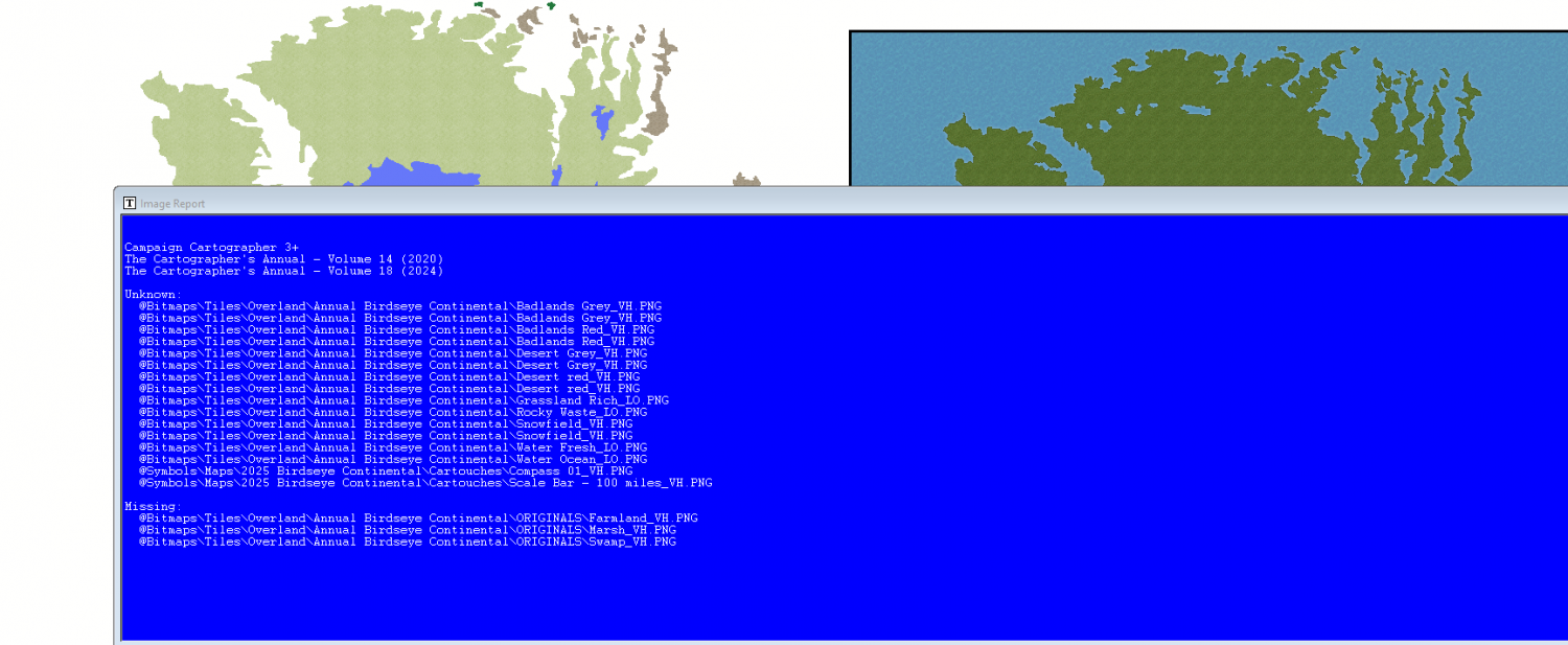
Could this be, because I copied the basic continent and pasted it into the new style?
Cal
Comments
SOLVED
thanks again
Cal
Hi Calibre :)
You have inadvertently uncovered a mistake I made during the development of the style. Somehow, I replaced 3 of the fill style symbols with bitmap fills from a folder that only exists on my home PC.
To get rid of those 3 'missing' fills listed at the bottom there, open your Symbol Manager and check the Show fill style symbols box at the top of the dialog.
You will then see this at the top of the list, only you will have 3 extra fills called Swamp, Marsh, and Farmland that are all red Xs. Pick those three using CTRL to pick them as a group and hit the Delete button.
Ralf will be updating the template later to add those two missing drawing tools we discovered yesterday during the live mapping session. The repaired templates will be part of that download, but maps like yours made from the old template will need this repair.
Thanks indeed, Ms. Sue
I have other issues with your awesome Birdseye Style. Should I list them here or start a new thread?
thanks!
Cal
You can do either, or you could send them to Tech Support where Ralf stands a chance of putting them right before he uploads the new download.
Well, these are general but I'll do both heh.
The Uneven Ground overlay texture fairly disappears when placed on Snow and Ice fills.
I see no forests set in the snowy or icy color schemes? I had to melt my brain using RGB matrix processor to get close.
Also, is this scale correct for the forest fill? It's Pine in the screenie. I followed Ralf's instructions to the letter to alter the map size---first opening the new map in the default size then changing it via File option....?
thanks
Cal
Uneven Ground is used all over this area in my map.
PS: over, before you ask, no, I did not alter the order of sheets in any fashion and Uneven Ground is lower in the list than Snow or Ice
😁
I mentioned the fact that the chameleon hills don't work well in the arctic regions. The same applies to the uneven ground texture. Maybe that should be noted in the margin somewhere? It's because the arctic fills (snowfield and ice) are too white as a base for the sheet effects. If you really wanted them to work on the ice and snow you could (given some time) add a new uneaven ground terrain sheet and fiddle with the blend modes to get something more noticeable, perhaps. No promises though. I tried it and failed. That's why you have a snow hill drawing tool.
There are no snowy forest fills, but you have made a good solution.
The map size only affects the symbols, not the fills. The fills will be the same scale no matter the map size.
AHHH!
Well, I failed to read the full instructions, I see. I beg your pardon.
As for the scales of various fills, I usually alter them as I feel they match what I see in my twisted brain heh heh. I just wanted to verify I hadn't altered something subconsciously 😁
thanks again
Cal
No worries, Calibre. I was rather long-winded in the Mapping Guide.