

CC4 Overland Development Thread
 Loopysue
ProFantasy 🖼️ 41 images Cartographer
Loopysue
ProFantasy 🖼️ 41 images Cartographer
Thank you for sharing all your favourite overland styles and giving me a little information about why they are your favourites. This was a very enlightening thread for me. I hope it was for you too.
This thread is to show the development of CC4 Overland, or as much as might be interesting to you. It's also an opportunity for you to express your thoughts on how it's going and make suggestions about improvements. Not all suggestions will necessarily be incorporated, but they will all be seriously considered.
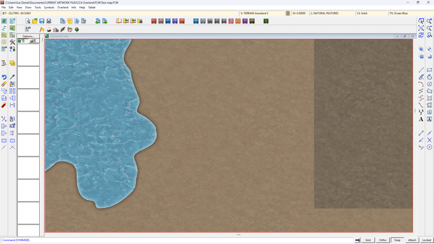
So far, I've started with the textures. The initial Land texture I showed a glimpse of in the thread linked above ended up being too busy for it's own good, so it was dumbed down quite considerably to be more of a subtle blotchy background for the more important stuff - the terrain textures and symbols to come. There's also a draft ocean texture.
I usually start by doing all the textures first, but I've also been thinking about the mountains, hills, mesas, craters, etc. I needed good reference material and a way to keep my drawings consistent, so I used Blender to create models for myself.
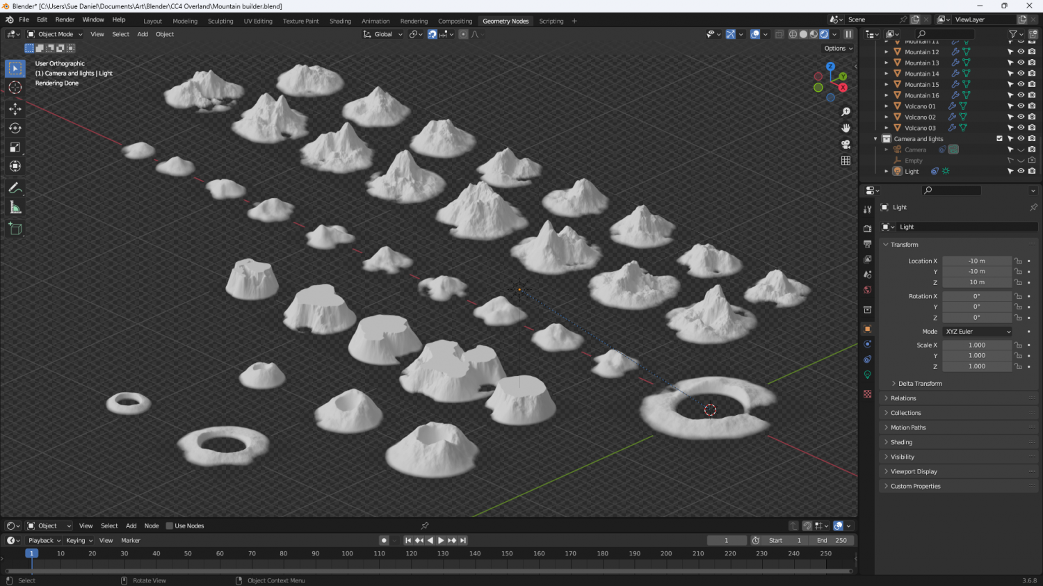
There is a landscape add on available in Blender, but it doesn't provide the right options for me to get what I wanted, so I made my own set of geometry nodes. I know there are other Blender enthusiasts among you, so here are the nodes for the mountains if you want to have a go at making one of your own. I've scrunched them all up as close as I can so you can read them.
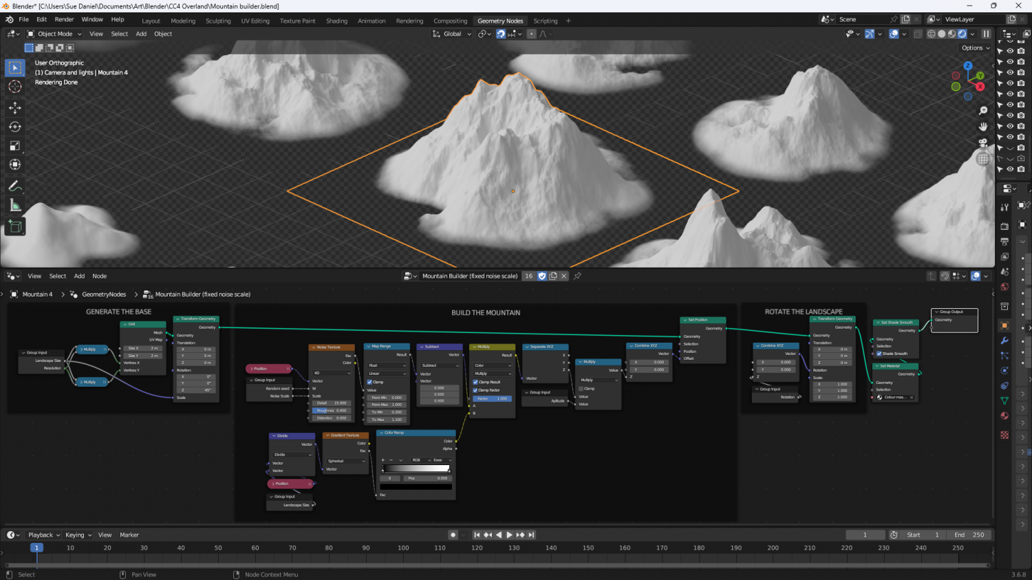
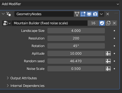
And here are the variables for the active mountain (outlined orange above). My spelling is still really bad. 'Aplitude' is meant to be 'Amplitude'.
Now begins the long process of hand drawing the mountains based on the models I've just made.
Please feel free to comment and make suggestions.


Comments
The image for the node setup turned out a bit blurry, so this is it again in a more readable fashion. I continue to work in Blender version 3.6.8 even though there are more up to date versions. They update/upgrade in a fashion that damages version compatibility. Some of these nodes no longer exist in the current version, or exist in such a changed state that they don't work the same way.
In the first image I use 2 Math nodes to do the same thing. This can be done with just one linked to the same inputs and outputs.
Have fun! :)
Hi, Sue. I have one request - don't make the hills too 'peaky', but make them more smooth - I hope you get what I mean - unless you do 'foothill' which are more 'peaky', and lesser hills which aren't so pleaky.
Why don't you expand the Spectrum style for this?
Although the mountains are not so "peaky" and are easier to fit together to make a Sierra/mountain range, I agree with Quenten.
If I could choose, I would leave these "peaky" hills - because more and more and infinite icons are always useful, but also smooth hills.
If I had to choose between the two, I prefer go with the smoother ones.
P.S.: The shape of the mountains is really beautiful. The first time I saw the image with all the icons together, they completely captured my attention.
I also comment that the viewing angle of the mountains and hills is very beautiful, I don't know if that is the correct term to express it.
P.S. 2: The texture of the water is also very beautiful.
Thank you, both :)
Ok - less peaky hills. Agreed.
@Quenten I wanted a fresh start with complete design freedom (taking suggestions into account). Spectrum is already full of things that I would have to continue to match against, including a colour scheme and a set of textures that aren't as good as I can do these days. Having to make everything fit with things I no longer consider my best work would be quite limiting. I'm hoping that CC4 Overland will be better than Spectrum. I hope it will be anyway.
@Ricko Yes, the angle of view for the model shot is quite a lot more oblique (side view) than Spectrum, which was absolutly isometric in all symbols. What I've done above is not true isometric, but like you I think it looks better. When I draw the mountains and hills I will probably flatten the bases very subtly, or make them less obviously rounded so they can fit together even more easily.
I agree with Quenten and Ricko, Ms Sue
A version of hills, if possible, more rounded or 'smoother' would suit me well. Keep the others if your resources/time allows, please.
If you could create some that more closely resemble English 'Downs', well, we'll be BFF!
😁
Cal
@Loopysue I understand your attitude about not revamping Spectrum. Thanks for replying though.
@Quenten I'm really flattered that you like Spectrum so much. Thank you for that.
I would love to be able to show you a brand new improved mountain symbol right now to win your trust that this will be better than Spectrum, but as it is the day has been rather busy, so it's not ready just yet. It will be done soon.
Since this if for an entire style, not just an annual to be added on to existing content, I am for the peaky and weather worn mountains. I would prefer the foothills option to transition from land to mountains. I generally prefer rolling or softer hills. I think the challenge with these is to make them suitable for various different biomes. The rain soaked mountains of the Pacific Northwest are very different from the Himalayas or mountains that have been eroded over millennia.
Regardless of the mountains that get made, I do like having the ability of putting in ranges and not just individual mountains.
Yes, I have been thinking of ranges. These models are basic inspiration and could be combined in a range symbol once I get past the basics of how big to make them and how much to modify the general appearance.
The smoother hills are a popular request.
Maybe one or two images of generic cave/mine entrances which could fit into hills and mountains? I mean, just an image of the entrance. I don't know if I explained myself well.
I second Ricko's comment about caves and mine entrances as stand-alones. Also waterfalls that are stand-alones, not associated with cliffs etc, so they can be places anywhere - would need 4 symbols for 4 different angles, i guess.
And Sue, you have my trust - no need to show the mountains until you are ready. One of the things I did appreciate with Spectrum was that you had green mountains , ie, those with vegetation - like so many of lower mountains are around the world (and especially in Australia, where to eucalypt oil of the gum trees gives the mountains a 'blue' look from a distance - which is why we have the Blue Mountains just west of Sydney
When does a mountain become a hill, or a hill become a mountain? I've got all of them now I think.
Thanks for the suggestions :)
Those green mountains in Spectrum were more about matching the terrain details. I don't think I did a mountain background for that style, so there had to be mountains for every occasion. There is likely to be a mountain background in CC4 Overland, though I haven't really made my mind up about that yet.
Ms. Sue
Those look absolutely perfect! Thanks for your hardwork.
PS: any ideas how this CC4 is going to work? Meaning, it's a completely separate program or will it upgrade CC3? My instincts tell me a completely new program....
Cal
PS: apparently, official sources indicate there is no difference between hills and mountains. There used to be, but both UK and US abandoned the distinction in mid 20th century. Generally, the old definition had a hill as rounded with a summit less than 1000 feet.
Thank you :)
CC4 Overland is only a style, not the app itself. The reason it's called CC4 Overland is because it's intended for release with the upgrade to CC4, just like the mapping style called CC3 Standard Overland was released when CC2 was upgraded to CC3.
Because it's a style rather than the app itself, I imagine that it could be used as easily on CC3+, though I'm not sure if it will be available separately if you don't have CC4 when it comes out. That kind of decision lies in the future.
That's really interesting about the hills and the mountains. Thank you :)
Are you thinking of cliffs that point in all directions, like Darklands? Maybe two groups of images: one with a straighter line (relief) (Darklands style), maybe another more rugged with more indentations and sinuosities.
Yes, I will be doing cliffs. The style should be about the same size, and the same range as the basic MS style without the free monthly stuff to start with.
However, since I've only just finished rendering the full set of mountain and hill models from Blender, that may be a few weeks away yet. First I have to figure out the finer points of the style with the mountains as test guinea pigs. Should there be inking? Should they be generally darker or lighter at the top? How big should they be, and what exact colours should I use? Those kinds of questions. It takes several iterations and redrawing the same thing over and over till it's right. I expect you will all be really bored of seeing slightly different versions of the same few mountains before I'm satisfied they are good.
And then I might dive straight into the structure symbols. One of the weak points of my overland styles is that they never have enough structure symbols, so I want to change that by moving them up the list of priorities because some of that weakness is due to the fact that they usually get left till last.
Although... I might need to do the textures straight after the mountains to establish the colour scheme.
Here is the first mountain draft dropped down on isometrically scaled borrowed Birdseye Continental textures. There will be new textures specifically for CC4 Overland, but the colour scheme will be much the same.
There are several things wrong with this first draft, like the base shape (which should be level rather than tilted) and the mountain colours (which definitely won't be kind of brownish), but the painting style is more or less the one that's worked best so far - no inking, but everything drawn with ink-style lines, but instead of drawing in black they are drawn in colour.
What do you think?
The mountains by themselves, I like. I think it is an interesting style choice that could provide a lot of map style flexibility. It has an almost painted like quality.
My concern is really with the textures. In HW, there are black lines on the mountains. There is also black lines on the default land texture. There are really black sketchy marks on all of the symbols and most of textures. All of this makes to blend together.
I am thinking that in order for this style to work, you will also need to make sure your line work on the mountains blends in with the textures in the way that HW does so that it feels coherent. While I know that these are placeholder textures, the patterns for most of these do not seem appropriate for the mountains.
Thanks - it is a painted technique.
Don't worry - I'm only using the Birdseye textures as an indication of colour scheme. It looks like the best way to do this is to hand paint everything.
Not sure how this works digitally, but I feel that hand painting takes longer. But I am sure it will be worth the extra effort.
Hand painted using a Wacom Intuos and Affinity Designer. It's not the same, but I do also have Rebelle 7. Unfortunately, Rebelle 7 doesn't allow seamless canvases, so the texture tiles would be a problem. Artrage (which I also have) does allow for seamless canvases, but I find the result less realistic than Rebelle.
I will find a workflow.
Virtual hand painting takes about the same time as messing around trying to do it other ways. It's all very much the same once you no longer use traditional materials.
The darker lines in the center of the mountain look like that part is being sucked into a funnel towards the center of the earth. 😂 Jokes aside, I really liked this sandstone color on the mountains.
Do you plan on making multi-colored symbols, Sue? They are very versatile.
That is indeed a hollow in there.
Thanks :)
I always make varicolour symbols.
Don't forget this is just a first draft. There may be many different versions.
Sue commented: Don't forget this is just a first draft. There may be many different versions.
That's a shame; I kinda want a complete style with this look now 😉😁! Could be a lot of new Annual issues in it, Sue 😎!
We could carry on collecting all the different types of mountain drawing I go through, but you would probably end up with a set that would take up quite a bit of space on disc.
Hard drives are cheap, and get bigger every year. 😄
Here's an idea I had the other day - to paint everything in Artrage. First I tried a grass texture, which unfortunately will have to be redone because the paint was too thick and left odd lumps.
I've added a couple of Mike Schley mountains for scale, and the previous unpainted and very draft mountain I did a couple of weeks ago. If I go down the oil painting route for the whole style, the resulting maps will look like detailed oil paintings.
Please ignore the funny lumps that look like I threw a bucket of dust at the canvas, and let me know what you think?
The oil painting look is lovely.