

Britannia (Parchment World)
 Mike Patterson
🖼️ 11 images Surveyor
Mike Patterson
🖼️ 11 images Surveyor
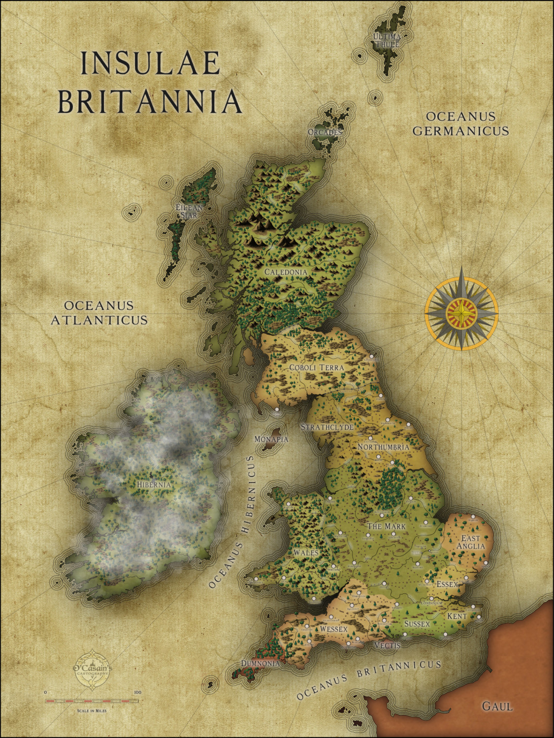
We're starting a new campaign for our annual "LakeCon" this year, and the first GM in our round-robin rotation asked me for a map. The setting is an alternate history Britain/Scotland/Ireland, about 150 years after the Romans left. I'm pretty happy with this one. Everything is from the new Fractal Parchment World style, with the exception of the trees - they're from the 2022 Jon Roberts Revisited style. The mist/clouds over the mysterious fae lands of Hibernia were added in post production in Affinity Photo.
The final map for the group I exported as a layered PDF so that the mist can be turned off if/when we need a clear view of the fae lands.
Gallery Link (Hi-Res Image, w/ Misty Hybernia)
Gallery Link (Hi-Res Image, w/ Clear Hybernia)


 and 8 others.
Comments
Looks pretty cool.
Some text does get lost in the coast outline.
I guess the text will look fine when the map is either printed out or zoomed in - the 'problem' of text being too small is often an artefact of the size of the screen on the forum.
Just adore this map.
Thanks, Quentin.
Yes, the text does look much better in the hi resolution version.
I experimented with making the glow stronger, and with changing the text color of the labels around the coastline but couldn't find anything I liked as well as this, imperfect as it is :(
Also, I now realize I might need to cull some of the trees from Sherwood Forest - it's supposed to be dense, but it really, really stands out from the rest of the map the way it is.
Are the clouds just from one of the annuals with a drop shadow effect?
You've done a brilliant job on this map, but I hope to hell you've put Lancashire in Northumbria and not Strathclyde.
Dak.
Thank you for posting this in your galleries so we can zoom in and see more details. It is really magnificent. And I just noticed your custom cartouche with your "maker's symbol." Great idea! I may have to come up with something inspired by that for the Royal Scribe.
Lovely map! Have a great LakeCon with your friends! I recall you telling us about it and thinking how envious i was that I couldn't possibly get my friends to all commit to something like that. Great gaming to you all!!!
Thank you all for the kind words!
@Dak - Lancashire? :D
@JulianDracos - I added the clouds in Affinity Photo. They're the "Fog 4" brush from the Dreamscapes brush pack.
@Royal Scribe After I did an innocuous Google search about starting an LLC, Rocket Lawyer started bugging the heck outta me about getting going on it. One of their suggestions was a trademark, and that prompted me to make this. I think your forum icon would be a great start on a maker's symbol for you - I've admired it for awhile.
@Lorelei - I continue to be humbled and gratified every year by the dedication of my friends to our gaming weekend, and amazed at the excitement we all have for it not only during the event but throughout the entire year. This will be year 19!
I made a few changes:
I also figured out how to sharpen the image in the OP, and relinked to the updated gallery image. I think this one is all wrapped up now.
This is a very impressive and detailed map (speaking as someone who's mapped various parts of these same islands at various scales over many years)!
Appreciate this is for game use rather than historical precision. However, the lines of both the Antonine and Hadrian Walls are a little off their actual ones - Hadrian's Wall follows along not far from the north bank of the Tyne in its later eastern stages, and ends at Wallsend (surprise!) on the north bank more or less opposite Jarrow on the south bank (at this scale), for instance. Not sure how important this may be for your purposes though 😊.
Seeing what else has been labelled, it may be worth thinking of adding some names for the more important old Roman roads, as some at least were still in use by the c.560s CE and later (some major roads still follow their lines today), and a few of the surviving names seem to have their origins in the Old English/Anglo-Saxon language.
Thanks, Wyvern. I had thought about naming a few of the roads, and may get around to that. I'm not too stressed about getting the details exact - I did the walls and roads mostly just by eyeballing them on maps a quick search turned up, and then threw stuff in where it made the most sense to me given the rough outlines our GM threw at me.
I do always like to learn the facts though, even when I take a "close enough" attitude on the map 😁.
I added the version of the map without the mist over Hybernia to my gallery, in case anyone wanted to look at it. To me, the mist really adds to the map and Hybernia isn't nearly as interesting without it. In this game, almost nothing is known about Hybernia, so I didn't put anything there other than the major lakes and rivers (w/ my own mishmash of Gaeilge names).
Both are now linked in the OP.
That is a beautiful map!
Thank you, landor!
Love this map. It is inspiring me to redo a map I gave up on in the past.
What are the trees from?
They're from Jon Roberts Revisited (2022).
Are those the fills from John Roberts as well?
There are actually no bitmap fills in the map other than the standard ones that come with the style (land and sea). The different territories are set off by a layer with different colored solid fills and a blend mode. I just realized I've never attached the CC3+ file so folks can take it apart - here it is. The maker's mark will show as a red X, of course, but I think everything else should be fine. It's really very basic.