

Sticky Note Dreamlands - An Experiment
 Wyvern
🖼️ 293 images Cartographer
Wyvern
🖼️ 293 images Cartographer
Thinking more about the new Sticky Note Dungeon Annual just released yesterday, while checking it over and afterwards, it occurred to me that with a few additions, it could be used equally to generate a form of point-crawl overland map too. For those unfamiliar, this is a sketch that links places of interest in a pattern to identify how the various points can be reached, without bothering too much about the exact distances, directions or terrains intervening - except that things such as intervening difficult terrain might mean no direct links, with instead a set of further points bypassing the blocking feature to be encountered along the way.
As an example, I created this map almost ten years ago now for a wargaming magazine article on Jason and the Argonauts, showing a stylized series of overland connections along the western and northern Black Sea shores of Anatolia, into about the middle of that great peninsula, and along the coast north to modern Georgia, ancient Colchis:
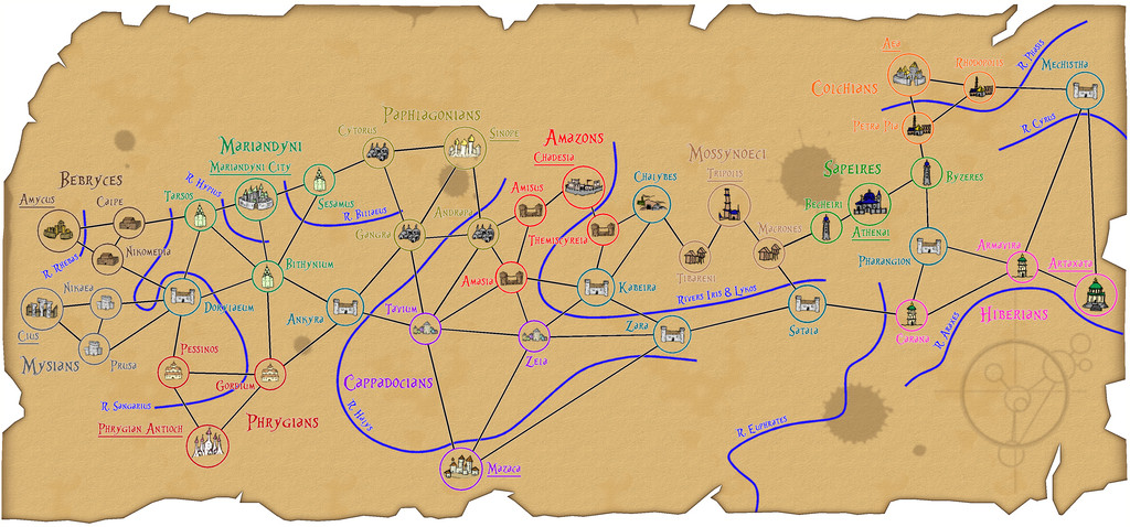
This isn't all that clear at the usual Forum resolution, so I've added a further version at higher-res to my Gallery.
Thus essentially what can be drawn for such a system is a very simplified map, one that here even ignores the coast, and features only the main river lines of significance, chiefly those that cross travel routes, all in a rather abstract manner.
Something that's long been of interest to me has been trying to map the places referred to in H. P. Lovecraft's stories concerning his Dreamlands. I've had a couple of tries at this myself, the first time almost 40 years ago, and another that sadly didn't get very far more recently, using the beautiful E Prybylski Watercolour style from last year's Annual. Several other vastly superior to me artists have created their own versions of such a map over the years too, which all have their pros and cons.
One main difficulty is the details in Lovecraft's tales don't include things such as specific distances, or where different places might lie in relation to those mentioned in one story, and perhaps only obliquely referred to in another. Distances might be given in terms of hours or days sailed or flown on sea or in the air, or overland by yak, zebra or on foot, or might just be stated as being a long way apart. It's possible to estimate real distances by making assumptions, but this still doesn't help in locating where some of the places mentioned, but not passed through, or directly connected to elsewhere, were.
In the stories, as it would in genuine dreams, this all makes perfect sense, since these aren't real places, and Lovecraft was a lifetime lucid dreamer, so was writing more or less from experience. As a mapper though, it quickly becomes problematic.
However, the Sticky Note concept helps here, by generating a means to show places with some details about them, and lines showing how they connect, without worrying about details on exact directions, distances or even the size of a given place.
So I tried a quick version as a test earlier today. Had to create a couple of new drawing tools, and import a bunch of symbols from the SS1 Handrawn Hollow set, but it was all pretty straightforward. I drew out just the places along the Southern Sea coast, heading westwards from the great city of Dylath-Leen, as described by Lovecraft, using an annotated hand-sketch I'd prepared last year when working on the E Prybylski version:
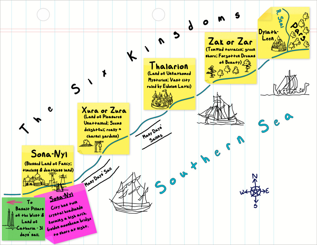
Obviously, a lot more could be done than I've tried here, and this is a bit rough-and-ready in places, but the basic concept seems sound.
These SS1 hand-drawn symbols seem to work quite nicely, although I'm sure none of us would be averse to having a purpose-made set in the C. C. Charon style, should an overland version of the Sticky Note style be offered subsequently 😁!
(We might need an A3 or larger option for the paper to draw world-sized maps though 😉)


