

[WIP] 1972 Travelogue (CA93 Modern Journeys)
 Royal Scribe
🖼️ 388 images Mapmaker
Royal Scribe
🖼️ 388 images Mapmaker
Using two of Ralf's recent tutorials, Modern Journeys and Real-World Vector Data, I was finally able to create a condensed map of a 71-day vacation my parents took me and my twin on when we were 4 years old. (The images for the icon symbols are all public domain or CC-BY. Photo credits below.)
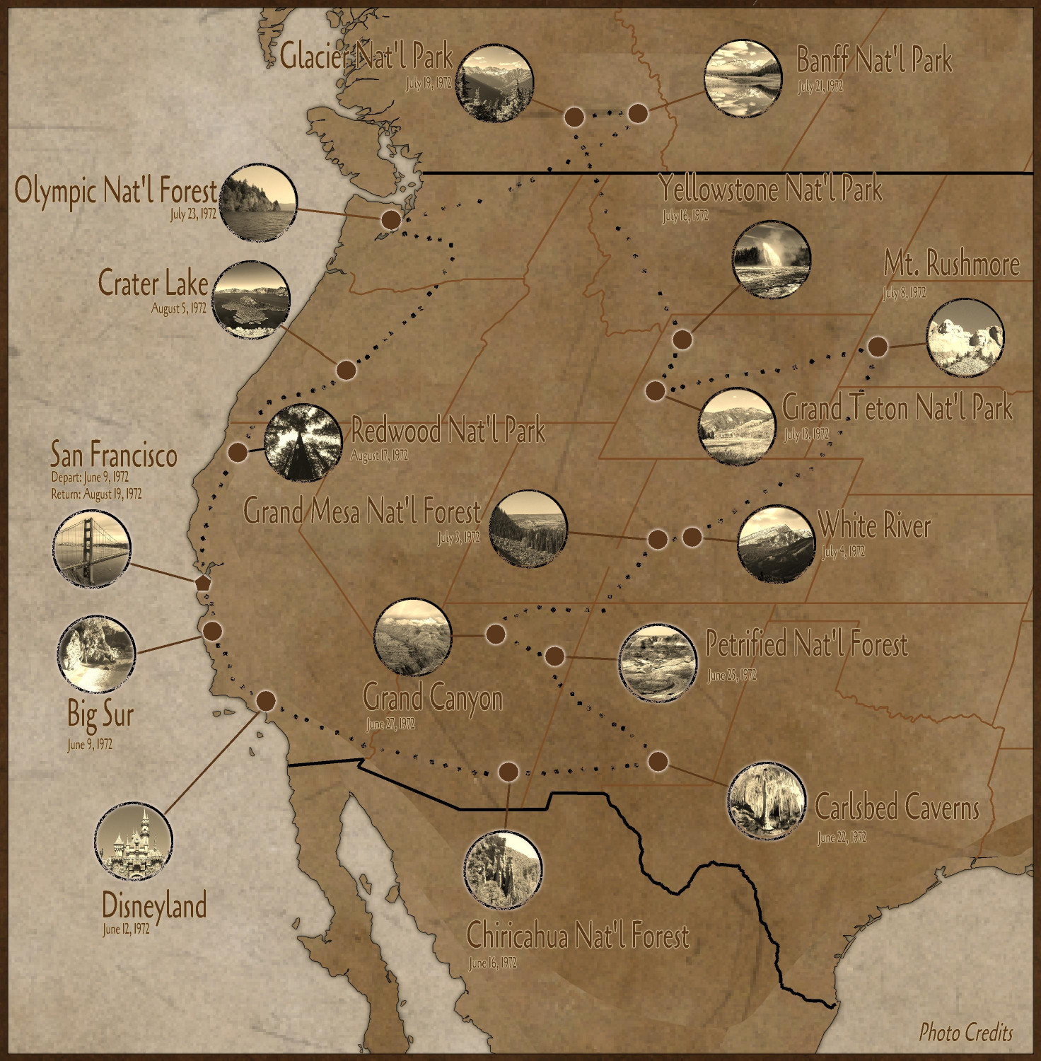
Like Ralf's Real-World Data tutorial, I had weird gaps in the middle of my map when I tried to convert the vector lines to land. Unlike Ralf, I didn't have the skills to be able to resolve it (despite watching the tutorial three times)...so I kludged a solution by drawing more land over the gaps. There was some other weirdness on the eastern side of the map that I didn't even have to worry about once I realized that I only had to show the part of the U.S. where we traveled.
Also, because I wasn't shading each state differently, I didn't have to trace the boundaries the way Ralf did. I simply moved the lines to a Border sheet and changed their properties to be the color and line thickness that I wanted.
I originally was going to source the photos from the U.S. National Park Service's website, where they have a database of images from their parks that are all in the public domain. (In the United States, all intellectual property published by the government is automatically in the public domain.) I was struggling to find images I liked, so instead I resorted to Wikimedia Commons. I made a point of only using photos that were either in the public domain or were published by a Creative Commons CC-BY license. Those licenses allow for commercial use, unlike the CC-BY-NC licenses (even though this isn't for commercial purposes), and allow for derivatives (unlike the CC-NY-ND "no derivatives" licenses). That allowed me to edit the images to be in sepia and cropped into circles. Instead of following Ralf's approach of making them sepia in the map, I used GIMP to desaturate them to sepia and then crop them to a circle which was then exported to a PNG (with the portions outside of the circle being transparent).
I added the photo credits to a Map Note and added a hotspot in the lower right corner to open up the note. Here are the photo credits (including some I wasn't able to use because of space considerations):
San Francisco, California - Dasturias, CC BY-SA 4.0, via Wikimedia Commons
Big Sur, California - Brian Lopez, Public domain, via Wikimedia Commons
Los Padres National Forest - Damian Gadal, CC BY 2.0, via Wikimedia Commons
Disneyland - Tuxyso, CC BY-SA 3.0, via Wikimedia Commons
Chiricahua National Forest - Zereshk, CC BY-SA 3.0, via Wikimedia Commons
Carlsbed Caverns - Eric Guinther, User:Marshman, CC BY-SA 3.0, via Wikimedia Commons
White Sands National Park - uncredited NPS employee, Public domain, via Wikimedia Commons
Petrified National Forest - AndrewKPepper, CC BY-SA 4.0, via Wikimedia Commons
Grand Canyon - Tuxyso / Wikimedia Commons
Glen Canyon Dam @ Lake Powell - Christian Mehlführer, User:Chmehl, CC BY 2.5, via Wikimedia Commons
Grand Mesa National Forest - National Archives and Records Administration, Public domain, via Wikimedia Commons
White River National Forest - JasonC photography, CC BY-SA 4.0, via Wikimedia Commons
Mt. Rushmore - Colin.faulkingham at English Wikipedia, Public domain, via Wikimedia Commons
Teton National Forest - US Forest Service, Public domain, via Wikimedia Commons
Yellowstone National Forest - Brocken Inaglory, CC BY-SA 3.0, via Wikimedia Commons
Glacier National Park - TaikiMcTaikiface, CC BY-SA 4.0, via Wikimedia Commons
Banff National Park - Sergey Pesterev / Wikimedia Commons
Mt. Baker National Forest - Joe Mabel, CC BY-SA 3.0, via Wikimedia Commons
Falls View, Olympic National Forest - Forest Service of the United States Department of Agriculture. Public domain, via Wikimedia Commons
Crater Lake, Oregon - DSparrow14, CC BY-SA 4.0, via Wikimedia Commons
Redwood National Park - m01229 from USA, CC BY-SA 2.0, via Wikimedia Commons


Comments
The map is just the highlights of the trip. Here's the full itinerary. Why two weeks at Crater Lake? My extended family has a cabin a few miles outside of the park, so we were visiting family then before finally heading home.
June 9, 1972 — San Francisco, CA
June 9, 1972 — Big Sur
June 10, 1972 — San Simeon
June 10, 1972 — Los Padres National Forest
June 11, 1972 — Los Angeles
June 11, 1972 — Angeles National Forest
June 12, 1972 — Disneyland
June 13, 1972 — San Juan Capistrano
June 13, 1972 — Chula Vista
June 14, 1972 — Winterhaven, CA
June 16, 1972 — Tucson
June 16, 1972 — Chiricahua National Forest
June 20, 1972 — Deming, NM
June 21, 1972 — El Paso
June 22, 1972 — Carlsbed Caverns
June 22, 1972 — Cloudcroft, NM
June 24, 1972 — White Sands National Park
June 24, 1972 — Cibola National Forest
June 25, 1972 — Petrified National Forest
June 25, 1972 — Coconino National Forest
June 27, 1972 — Grand Canyon
June 28, 1972 — Glen Canyon Dam
June 29, 1972 — Manti-Lasal National Forest
June 30, 1972 — Price, Utah
July 3, 1972 — Thru Utah to Colorado
July 3, 1972 — Grand Mesa National Forest, CO
July 4, 1972 — White River National Forest
July 6, 1972 — Shadow Mountain Lake. Through WY to Nebraska
July 7, 1972 — Cadron, Nebraska
July 8, 1972 — Mt. Rushmore
June 9, 1972 — Thru Gilette, WY
June 9, 1972 — Big Horn National Forest
June 9, 1972 — Shoshoni National Forest
July 13, 1972 — Teton National Park
July 16, 1972 — Yellowstone
July 17, 1972 — White Sulpher Springs, MT
July 19, 1972 — Glacier National Park, Canada
July 20, 1972 — Waterton, Canada
July 21, 1972 — Banff National Park
July 23, 1972 — Mt. Baker National - Snoqualmie National Forest. Olympic National Forest
August 2, 1972 — Mt. Ranier
August 2, 1972 — Maple Leaf-Gifford Pinchat Natl Forest
August 3, 1972 — Portland
August 4, 1972 — Salem
August 5, 1972 — Crater Lake
August 17, 2024 — Redwood National Park
August 19, 2024 — San Francisco, CA
And here are some zoomed-in closeups:
Excellent, very nice!
I have had a really close look at this map, and I am SO impressed. Sounds like a wonderful journey. It makes a wonderful memento of your travels, I guess.
It inspires me to do one of my move from Bowral, when my mother died in April 2023, to Geraldton in January 2024.
Quenten, I’m so sorry to hear about your mother. I look forward to seeing your map.
My family did another vacation like this in 1973. I don’t think there’s a travelogue of it but if there is, I will do a second map.
I think how the map has the slanted look to it as though it is sort of on a globe.
I think how the map has the slanted look to it as though it is sort of on a globe.
Yes, it does. It has to do with the source data I got it from (Mapchart.net). Even when you isolate the data to just North America, it's still drawing it on the globe, and I could not find a way to re-center it. I looked for ways to do that (I thought Utah would be a good central place for this journey), but couldn't do it. Another data sources might have worked better, but this was the source that Ralf demonstrated and it was a lot easier for me to work with than the source identified in the Annual's mapping guide.
Great map! But what an amazing journey your parents took you on!
It really was an amazing journey. I was only four, so a lot of my memories are vague and fuzzy (I have a vivid memory of hiking down a forest trail, but I have no idea which forest that was in.) I have strong memories of seeing bison at Yellowstone, the smell of sulfur at either Yellowstone or Whit Sulfur Springs, and the faces on Mt. Rushmore. I've been to Crater Lake many times because my family has a cabin a few miles away, so my memories of it all blur together. My parents took us another another 10 week trip the next year (my Dad was a graduate student who took his summers off), hitting different parks, but I don't think anyone has a log of that one.
Oh so this was something personal. My first reaction was oh this would be a cool Delta Green map. Were your parents by any chance Agents of Delta Green?
Cool map, the style caught my attention because I used it in a CoC game a year or so ago to good effect.
I had to look up Delta Green. No, not to my knowledge...but would they have told me if they were? ;-) They were hippies and back-to-the-landers. (A few years after this vacation, they bought 40 acres of undeveloped land covered in redwoods, and we lived there without electricity for eight years.)
What an amazing trip! And an amazing map!