

Green Mountains aesthetic question
 Royal Scribe
🖼️ 388 images Mapmaker
Royal Scribe
🖼️ 388 images Mapmaker
I am working on a 1000 x 1000 mile section of western Doriant for the Community Atlas. It's not yet ready for a formal show-and-tell thread soliciting feedback (and I will have lots of questions about whether I have successfully respected the parent map in the process), but I do have some aesthetic and scale questions.
The section in the blue border here is the section I'm working on (this is from the original FCW file):
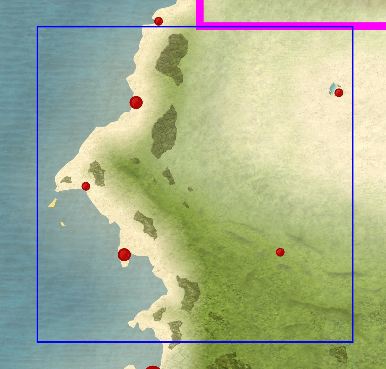
In the southeastern part, you'll see some beveled hills/mountains in green. In the original FCW, they are on sheets called Mountains Green II and Mountains Green III, each with different beveling effects.
I am doing this in the Mike Schley Overland style, so I figured I would render them using the mountain and hill symbols. I know this is a personal choice, but I always question my aesthetics. Since these are "green mountains" covered in vegetation, does it makes sense to use varicolor mountains and hills set to be green? Or would it be better to use the regular hills and mountains, and make them green by sprinkling trees on them? (The dwarven fortress stands out against the green, but maybe that's okay.) I'm fine spending the time to add 10,000 individual trees if that's what it takes. ;-)
And if varicolor works, does this varicolor work (#89 on the Mike Schley color palate), or is there a different shade you'd recommend? I wanted to get closer to the green of the land terrain, but I'm not sure which shade is closest.
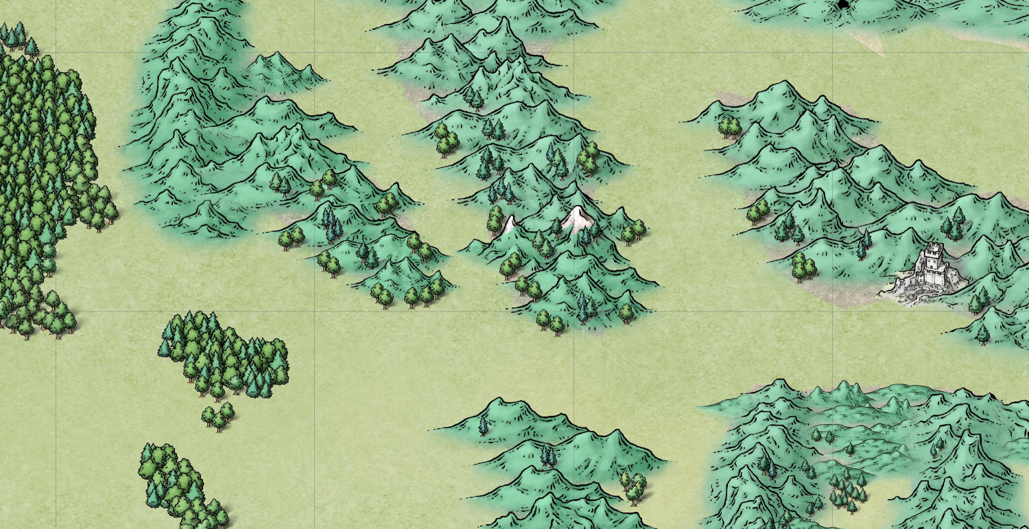
I mostly used the hills and small mountains because the "mountains" in the source map were so much smaller than elsewhere on the Doriant source map. Is that the right approach, or am I overthinking it?
Each grid square here is 100 x 100 miles. Do my symbols seem correctly sized for this scale or am I overthinking it?
Also, the 1,000 x 1,000 section I picked had virtually no rivers, but I assume that means it doesn't have anything like the Nile or the Amazon, but I can add smaller rivers?
This is the first time I've tackled taking a chunk of the Atlas to work on, so any advice on how to approach is welcome. (I've been following the approach used in the first half of Ralf's Detail Maps tutorial -- the copy method, not the cutting method -- as well as Remy's Changing Map Styles tutorial.)
Comments
Yes, add what rivers and settlements you want.
I think you would be better using the non-snow covered mountains in the Schley set, or even the grassy mountains in the Spectrum set, rather than varicolour (IMHO, anyway)
The Spectrum Overland mountains are absolutely gorgeous. I just did a sample of them along with more Schley ones with a greener green (the first was a little too blue-green). For the Spectrum Overland ones, I added Schley trees on the left and Spectrum trees on the right.
Would the Spectrum mountains and hills clash with the other Schley symbols?
They probably would over a large map because they are not inked, whereas Mike's styles are entirely inked. But it's all down to what you like in the end.
Inking is the black lines that describe the form of Mike's symbols.
Hmmm. I’m going to sleep on it. There are so many great Schley symbols, but a 1000 x 1000 mile map might not take full advantage of them. I could do Spectrum Overland the largest map and Schley for the smaller ones.
But the varicolor ones aren’t really working for me, so I’d probably go with the non-vaeicolored ones if I stick with Schley.
I'm starting over and doing the main 1,000 x 1,000 map in Spectrum Overland, but I am encountering a problem: CC3+ keeps crashing.
I created my new map in the Spectrum Overland style. I copied the "window" on the full Doriant FCW showing the borders of the area I'm working on, and copied it over to my new map. So far, all has been as before. Hid all of the sheets except the LAND sheet. Turned off sheet effects. Zoomed in a bit to the two islands off the coast. Did one fractalize command each for the two islands and the mainland. Hit save. So far, so good.
Then I did "Change like draw tool" to change the islands and mainland to be land. It worked. (Saved again.) But now when I try to Zoom to Extents, or even use the negative magnifier more than one click, it crashes.
I thought it would help to turn off sheet effects until I've gotten my land and terrain scaled back to within the borders of my map, but it continues to crash regardless whether sheet effects are turned on or off.
I would restart once more, with a new map.
It sounds like you have a little too much fractalisation going on there. It's safer to try not to fractalise more than 3 times with the default settings.
I think too much fractalization was indeed the problem. I only fractalized the mainland once, and each island once, all with the default settings. But I think it was an entirely different set of nodes causing the problem.
The first time I forgot to hide the BACKGROUND, SCREEN, and MAP BORDER sheets before copying everything over, but I tried it again with those sheets hidden and still had the problem with it crashing after converting the land. This time, I also hid the UNDERWATER LAND and UNDERWATER LAND II sheets, since I wasn't using them anyway and it was like bringing in another unnecessary continent. That appears to have done the trick: after converting the land, it seems to be stable (so far!).
Thank you!