

[WIP] - King's Shire - critique sought.
 Reddog
Traveler
Reddog
Traveler
King's Shire is a made up English place, early medieval which is going to be the setting for my first foray into RPG. As you'll have seen, I'm only just starting out in CC3+ and still have a long way to go to get to decent standards I think. I'd welcome some critique and some suggestions on how to improve these maps.
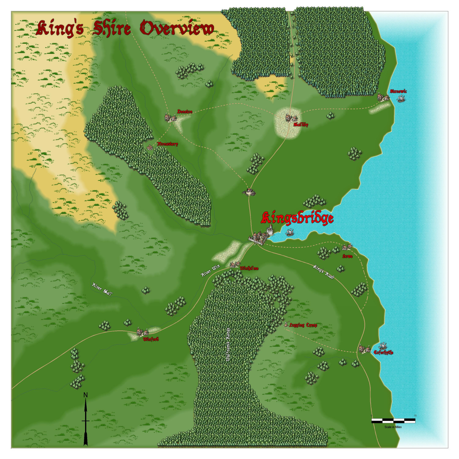
The general area of the shire is on a 100mile square map and shows only the core locations I have in mind at the moment. The map's a mix of Annual Shaded Relief and Mike Schley's Overland. The main areas I'm not happy with at the moment are the lack of a border, the title (I think it needs some sort of "box") and the compass/scale bars.
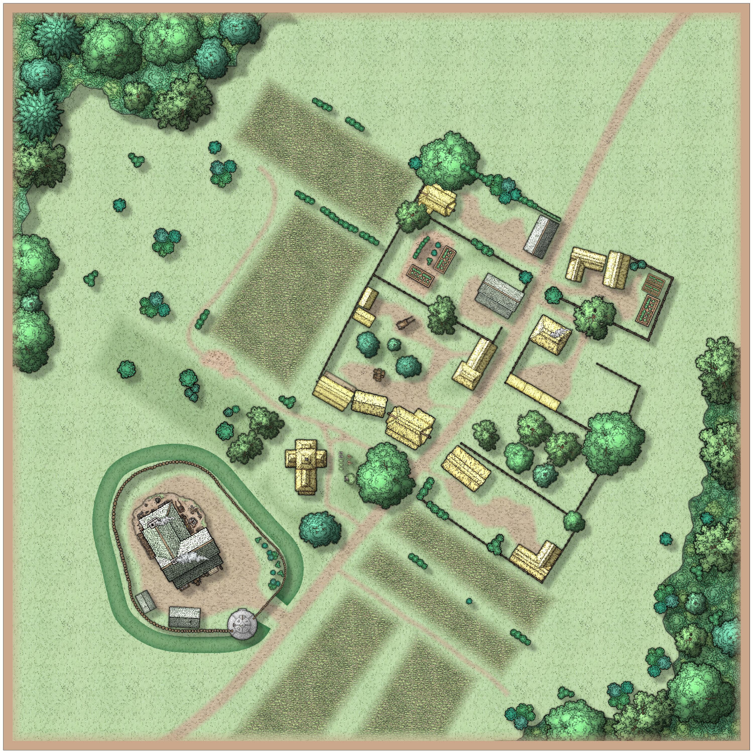
Winholme is the first attempt at a more detailed map, (using SS5 Cities of Schley) covering only a few hundred meters of the hamlet which has a small palisaded Manor and a few cottages. I still need to label the key locations/buildings + index and I think it could do with a title but every text I've added has looked crap so need some guidance here on how to achieve a good result - again I wonder about a box background.


Comments
These are looking great, Reddog.
About the borders generally...
How are you exporting these maps? I usually pick "JPEG Bitmap File" and in the Options I set the desired pixel width and height to the maximum size on the longest side of the map, then pick "Crop image to aspect ratio" and "Restrict image to map border". That crops the export to fit preciesly to the map border, leaving no white slithers around the edge of the map and giving you a long side of 3000 pixels in this example:
Try that first, and if you don't like the result we can explore the idea of adding a specific frame to the maps.
Hello. This looks great. I love the Windholme map. It looks organized, but not perfect. I could believe it's a real place.
My only suggestion for the overland map is to add some individual trees around the forest fill areas. They break up the monotony of the forests. I see that you have a few copses here and there, and that adds a lot of flavor. I think a sprinkling of single trees around the edges of the forest would make the forests seem more natural.
They look wonderful.
Hi Loopysue, I just used the default settings which appear on my install to be this:
Not terribly dissimilar to yours and do have the two ticks you mention. I will need to read the manual on what Progressive JPEG and Antialias do.
On the basis that I have got "Restrict Image to map border" ticked, then I do think that some sort of frame is required, do you?
Can you just check if both those maps have a set of green lines or something similar on the MAP BORDER layer, by hiding all the layers except the MAP BORDER. (Layers, not sheets).
Older styles have the green lines. Some more recent styles might have other things on that layer, but whatever it is should usually be the exact extent of the map.
Those settings should be cropping the white edge out of the picture. If there's nothing on the MAP BORDER layer, or those lines are not where they should be, it doesn't work.
The Progressive JPEG setting controls the export quality of the JPEG. If you use it I recommend increasing it to no less than 87, and more than that if you can afford the image to be more MB.
Antialias blends the adjacent pixels just enough to smooth jagged edges and does a lot to resolve pixelation. Be careful how much you add, though, since it increases the work size. If you increase the work size to more than 10,000 x 10,000 pixels you may have a few issues with exporting the map.
The Progressive JPEG setting controls the export quality of the JPEG. If you use it I recommend increasing it to no less than 87, and more than that if you can afford the image to be more MB.
The order of "Progressive JPEG" and "JPEG Quality" probably ought to be reversed on that line, but it was soooo tempting to put the checkbox in line with the others.
The numeric "JPEG Quality" value (0-100) controls the amount of detail to keep in the encoded image (0=little, 100=maximum - there's a file size vs. quality tradeoff).
The "Progressive JPEG" checkbox indicates if the JPEG file should be arranged so that a coarse view of the file is drawn early with other details filling in later (this feature is useful for large files on very slow dial-up connections, but requires support from the program showing the JPEG).
hiya Loopysue, if I've done it correctly (sheets - show all, layers hide all but MAP BORDER) then all I see is a black square line outline for the area map, and a black square just inside a green square line outline for the city map.
I can't use these settings for most of my maps as I get a "You don't have enough memory" error forcing me to break up the map into several images.
Here are the options I used that got me that wonderful error:
Also, I tend to get some distortions in the image of larger maps. It's a tiny error that is pretty hard to noticed by eye but when I put a map with a grid on a VTT, the grid doesn't match and the mismatch increases the closer you get to the bottom of the map. I noticed that the more passed it needs to do to export the map, the bigger the error. So I now export sections of a size that can be done in a single pass.
If you haven't done so, use the EXPORTSETMPPP (export set maximum pixels per pass) command with 40000000 (40 million) as its parameter. This setting will allow more pixels to be output in a single pass, meaning that fewer passes are required.
The out-of-box value is 4 million, which works on all machines, but is pretty small by today's standards. 40 million seems to work well for most folks, but you might need to adjust the value lower if it starts having out of memory errors. You might also be able to increase the value, but CC3+ wants to allocate about 10 buffers of that size during its export processing and you have a maximum working memory space of about 500 million pixels available in normal operations.
@Reddog - What kind of export are you using? If it is one of the Rectangular section bitmap types, I believe they override the checkboxes.
I have it set at 80000000 (80 million). This is the best setting I found for most of my maps. At 40 million I was still getting too many passes which resulted in the grid getting distorted and no longer matching the VTT grid.
The map that gives me the memory error works at 40 million, but it needs multiple passes. But I get that shift in the grid where it's a off by enough to cause issues in the VTT. That particular map ends being too big (file size) for Roll20 so it would have to get cut into sections. File size isn't an issue with Foundry, just the distortion.
I just exported to jpeg, I didn't do a rectangular section (I don't think)
Now you've got me really curious. I'm not sure why you still have a white border. Please can I see the FCW files?
We can work out how to add an extra border if you still prefer to do that, but it would be nice to get the real MAP BORDER on the layer of that name working properly first.
Sure, of course! I'm curious as to what I may have done to cock it up in the first place.
I showed all the sheets and hid all layers except the MAP BORDER on the Area Map and discovered there were 6 entities there. One was a screen. That's the white thing that goes around the outside of the map, and it belongs on the SCREEN layer, not the MAP BORDER.
I put it on the SCREEN layer, but that still left 5 entities on the MAP BORDER layer. However, these were all either lines or polygons with exactly the same extent, so I deleted all of them and replaced them with a single black hollow rectangle of exactly the same extent using the snap grid. It's possible that you may have accidentally copied pieces of the original MAP BORDER while you were working on the map. To prevent this happening I have frozen both those layers with everything in the right place.
Try exporting this version:
On the Winholme map I found the green lines demarking the MAP BORDER on the MAP BORDER layer were outside the extent for some reason. Not sure how that might have happened, but I have moved them back into place using the node edit tool with ATTACH turned on to snap them to the actual corners.
Try exporting this one:
If they both work now, then we have resolved the mysterious MAP BORDER problem, which was most likely caused by working on the map with both the MAP BORDER and SCREEN layers not frozen.
Oh, and I've just remembered! I turned off the sheet effect on the TERRAIN sheet in the Winholme map to be able to see the green lines at close range. You can switch it back on by checking the box next to it in the effects list.
If you still want to work on an additional frame that's fine.
Thank you. I'll take a look at the changes tomorrow when I'm back at my PC. I have to be honest, despite reading various threads about Layers and sheets, I don't see the need at all for layers, so have paid zero attention to them and have not intentionally changed or selected anything using the layers until you asked me about them in relation to the map borders.
I do think the presentation would look better with some sort of frame, and the city map especially is going to need a title and index so figure those can be part of the framing.
Sorry Kertis, I missed this reply. I agree, the forests don't look quite right, I might try redoing them with individual trees entirely, to make them a little less regimented and densely packed.
I'm glad you said tomorrow, Reddog. It's 11pm where I live, so that works for me as well.
If you are doing a really complicated map, layers and sheets can make a big difference when organizing.
My Suzail city map for campaign use makes a huge use of layers. I have 5 layers of an underground Dwarven complex. Each is on it's own layer. Same deal with the Sewers and the fresh water system. Also use layers for information such as campaign events and player house arrows. As well as arrows for chase sequences. Plus lots of ofther misc stuff. All of that stuff doesn't use sheet effects so there is no need putting it into sheets.
The main map has sheet effects for the pathway to the castle. I have a purple poly, underneath a coblestone fill with transparency so I get the look of a purple path up to the castle. Sheet effects also for the streets and ground to break up a solid fill.
Not sure if those are the actual true uses for sheets and effects, but that is how they work for me.
@Reddog remarked: I have to be honest, despite reading various threads about Layers and sheets, I don't see the need at all for layers, so have paid zero attention to them...
Like many things in CC3+, Layers can be powerful friends once you understand what they can do for you. Aside from the unique feature of being able to freeze and unfreeze things on a layer (something you can't do on sheets) - very helpful when trying to select something as long as it's on a different layer, for instance - as Don mentioned, you can easily hide or show entire fresh versions of your map using only layers. You can even toggle them by writing a little macro command, so as to do that with one click! Plus you can hide or show entire rafts of terrain or symbols, so long as you make sure they're on the correct layer. Like the GAME MASTER ONLY layer for hiding all kinds secrets the players shouldn't see (yet)!
Must admit, I've sometimes wished there was a way to group layers together, just as you can group sheets onto layers, so you could turn off or on an entire set of different layers at once. That's probably just me though 😁!
@Wyvern wrote:
Must admit, I've sometimes wished there was a way to group layers together, just as you can group sheets onto layers, so you could turn off or on an entire set of different layers at once. That's probably just me though
If you name them sensibly, you can achieve the same (But you do need to use a command, not the GUI). Say you have a bunch of layers with different kinds of GM secrets, then you can simply name them GM Secret Doors, GM Secret Traps, GM Secret Secrets, etc. Now, you can toggle the visibility of all of them with
TOGLF GM*, with the companion commandsSHOWFandHIDEF. ('F' here means 'Filter').That's useful to know Remy; hadn't appreciated that.
Let's not forget Ralf's advice:
Do not draw large areas with forests, instead draw small areas mixed with manually placed ones to vary the look. But overall, looks great. Good work.
😁
Cal
Ralf’s tutorials mapping Mirkwood really shows this quite effectively.