

Exporting map to jpg image - aligning grid with vtt grid
 Mika
Newcomer
Mika
Newcomer
A few days ago I bought FoundryVTT and I want to import the maps that I have created with, for example, DD3.
The problem that I am facing is that the grid of the map does not align with the grid of FoundryVTT.
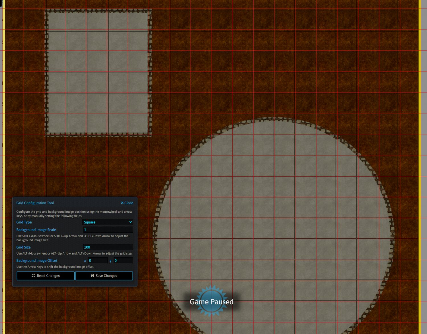
I have created a simple test dungeon with a suqare and a round room, and a aquare grid with the default spacing (10.00). I have saved the map as a jpg image and imported it into FoundryVTT.
In FoundryVTT the default grid size is 100px. I would expext that the grid would perfectly match, but it does not. I had to adjust the grid size in Foundry to a rather odd value. In this case 74px, and I had to shrink the map to 50% of its normal size.
I think that there is some setting in DD3/CC3+ that I missed, because when I imported a map from a different source, where I could set the grid size before exporting it, both grids matched perfectly.
What can I do?
The map in the example below is 20x20 squares and I want one square to be 100px wide. In the export options I set the image size to 2000x2000px. And this is how it looks when I import the map into my vtt.
Comments
The best way of dealing with grids (as I understand it because I don't use VTT), is to leave them out of the final export from CC3 but to add a 5ft square of a solid colour somewhere it won't be in the way and use it to scale the map to the VTT grid.
That sounds like a possible solution, but I want to use the maps as battle maps and then it might happen that a player token is half way within a room and halfway within a corridor, depending how far away it is from the square that matches the vtt's grid. And in some cases I need the grid from CC3+, for example, when I create a Traveller world map.
When you are exporting for VTT use and plan to use grids, make sure to always export using the rectangular section option. For example, if you look at your screenshot above, you'll notice that you have a border outside your map that is part of your image.
CC3+ isn't a "grid mapper", so export sizes are for the entire drawing, not just the gridded areas, so when you export the image in a size of 2000x2000, that border is going to eat part of that size, not leaving a full 100px for each grid square. But if you use rectangular section when you export and make sure to only export the map itself (use snaps on when defining the area to ensure precision) you should get the right size.
It is also important to set the export size correct in both dimensions.