

[WIP] Recreating Thedas
 Fey
Traveler
Fey
Traveler
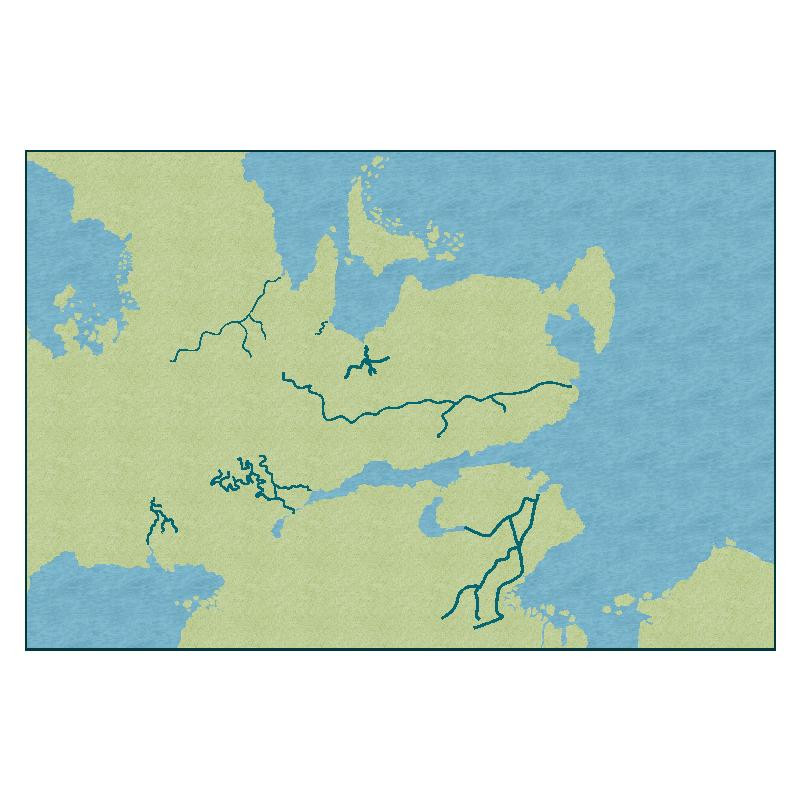
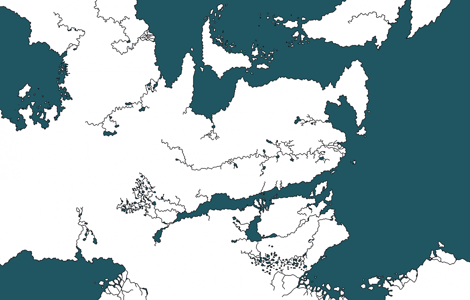
I'm VERY happy with the continent; I was able to create it pretty closely to the source image that I used as a trace sheet. :) I'm not certain that I like the rivers; especially since the source image has so many... But I might try out a few other ways of doing rivers.
* Attached the source image for reference to how the landmass should look.
All in all, for a real first go at using the software, I think I'm doing great. Excited to post updates as I work through this! I'm hoping that having an ongoing thread of my progress will keep me accountable to the goals that I want to set for myself.
I am open to feedback, or suggestions at every step in this process.
Tagged:


Comments
Looking good :)
With the rivers it might be easier to take one at a time and reduce the line width. You can do that using the change properties tool on the left toolbar.
Be quite careful to observe just one river at a time and look at where it really flows. They don't usually split like you have in the south there.
Thanks, Sue!
I'm going to give the rivers another go and avoid trying to make the two marshlands with the river tool, since that's what was super frustrating me when trying to figure out how I wanted to do the rivers.
Did you use the trace command for the land or do it by hand?
I did the landmass by hand. I've not learned how to use trace yet. 😅
It looked pretty exact with just the images on top and bottom and you turned the original into white, so I thought you probably used traced. So, I good job with doing it by hand!
Ahah, thank you! I couldn't figure trace out, so I worked really hard with the edit command line after creating a general landmass. :) I think that I 'll definitely figure out trace though, because doing it by hand was really hard.
So, I had to swap map styles because I couldn't figure out how to use tools or textures from other styles. :P But! I was able to swap to a map style with a marsh texture and a lake tool, which has made recreating the marshes and lakes much easier.
Most overland styles have marshes, including the Mike Schley style you started with. However, the MS style is so big you might not have found the drawing tool for the marshes.
Oooh, okay. There were a lot of tools.
Yeah :)
Mike Schley is the largest overland style we have. It's also been further enlarged with many of the free additional symbol sets published monthly and available to download on your registration page.
It's much, much larger than Spectrum Overland, so if you started with Mike Schley because you like it, it might be worth going back to Mike Schley before you really get dug in to the mapping, as it offers more flexibility.
Thanks! I'll play around with the Mike Schley overland style a bit more before diving too deep into the Spectrum. I do enjoy the Spectrum style, but I also really like Mike's style, too. (Decisions, decisions!)
I would rather Spectrum and Darklands be made default style with @Loopysue creating massive new symbols to use for them :)
I like MS, but Sue's symbols are a lot clearer. And she already has an awesome set of vegetation symbols. I hope ProFantasy will seriously consider beefing up Sue's style as a second option to MS
I was tempted to try Darklands, but I had trouble telling the continent apart from the default background. (Photo attached to show what I mean!)
You need to draw the sea first, not the land.
There is a pdf Mapping Guide in the issue's folder here:
C:\ProgramData\Profantasy\CC3Plus\Annual\Issue 173 - Darklands
Oooh, ty Sue! I'll play around with it here, shortly.
So I took Sue's advice and used the MS style due to the expansive symbol catalogues. :) I'm pretty happy with how it's going so far! I've still got to draw in the rivers, but progress is progress. :D
Looking good :)
If you are wondering why some of the terrain has sharp edges that's because the Edge Fade Inner sheet effect only acts on the outside edge of the combined polygons on that sheet. To give them all the same faded edge all the way around it may be necessary to create LAND FEATURES 1, LAND FEATURES 2, etc, and copy the EFI effects across to the new sheets, then move some of the land feature polygons to the new sheets. To avoid confusion I sometimes call them TERRAIN DESERT, TERRAIN MARSH, etc, so I know exactly what sheet something should be on when I move it.
Where you do forests you can make them look more natural by dotting a thinning band of single trees around the edge to break up the hard line.
Oooh, thanks for these tips Sue! I'll look into creating land features sheets. I think I know how to move them over to the sheet, too.
To create a new sheet just hit the Add... button on the left of the sheet list in the Sheets and Effects dialog. Then move it up or down the list to the best position.
To copy the sheet effects across from the existing LAND FEATURES sheet, pick the existing sheet and select the effects in the right panel, then hit the Copy button to the right of that panel. Select the new sheet and hit the Paste button.
You can move polygons or symbols to other sheets a number of different ways. I use the Change Properties tool as the fastest way, but you can also use Move to Sheet in the right click menu of either the Display Speed Settings button, or the Sheets and Effects button.
This is one of the reasons I find @Loopysue styles so much easier to use that MS. MS requires too much fiddling for my tastes. But, if you need a lot of different symbols, MS is the way to go.
I think the MS style is only lacking a few sheets, but it's made that way so as to not scare people off by having a sheet list that starts a mile long. My styles, on the other hand, tend to have sheet lists that start a mile long, which can be equally confusing until you get used to them. I've lately been trying really hard to keep them short(er).
Does the sheets place in the list change where the effects or symbols, etc. are? I'm not sure if that's the best way to phrase that question but... it's what I've got. lol.
@JulianDracos - I do need a lot of symbols! I'm trying to ensure that each nation has a slightly different structure style. It's not terribly hard to create sheets, though I'm still learning how to utilize the effects in each sheet. And how to make sure things are moved to the right sheet.
CC3 draws the BACKGROUND sheet first, and then draws all the others on top of it one after another all the way down the list to the bottom. So if you have something on a sheet near the bottom of the list it's on top of most of the rest of the map in your drawing.
If you want all the entities on a particular sheet to be on top of everything else in the map you would need to move it to the bottom of the list. Take care to leave the border and screen sheets right at the very bottom, though.
The effects on each sheet affect only the entities on that particular sheet.
Usually a sheet with a name that starts with SYMBOLS... has symbols on it, and sheets that don't start that way have lines and polygons on them.
Thanks for the explanation, Sue! That's very helpful. My latest question is about scaling... It'd seem while working up close in zoom, I've scaled my things nearly the same size across the map (at least I'm consistent!) but it seems too small when exported.
Is there a way to scale everything at once? Or would I need to do it one-by-one?
Regardless of the answer to the above ^, should I keep creating the map and worry about correcting the scale once I've added my major points of interests?
The scaling (or the default symbol size) is something that really should be set at the outset. But you've already done quite a lot of map. When you say it looks too small when you export it, are you exporting it always with this broad white border around it?
What export options are you using? These are controlled by the dialog that opens when you hit the Options button in the Save as... dialog.
Here is an example.
You can export the same map a lot larger by increasing either the Print Size or the Pixel Size. The settings above produce a much larger export than the default settings.
The Restrict image to map border checkbox should also cut out that large white border.
I've been wondering how to cut out the white border! Using the settings you've indicated above (just to follow your example!) my map comes out like this...
I think I mostly need to up the text size and the structure size.