

Scaling map for guide
 TakoTsubo
🖼️ 1 images Traveler
TakoTsubo
🖼️ 1 images Traveler
Hello guys,
I am new on CC3+ and i am little bit lost with Scales, i am followin this tutorial https://www.youtube.com/live/pzWirHveCM8?si=WueX2mkyACKGr-SR&t=480 , on min 8 aprox it shows how he scales a map with cc3+ units, i am trying to do the same but i dont know what i am missunderstanding.
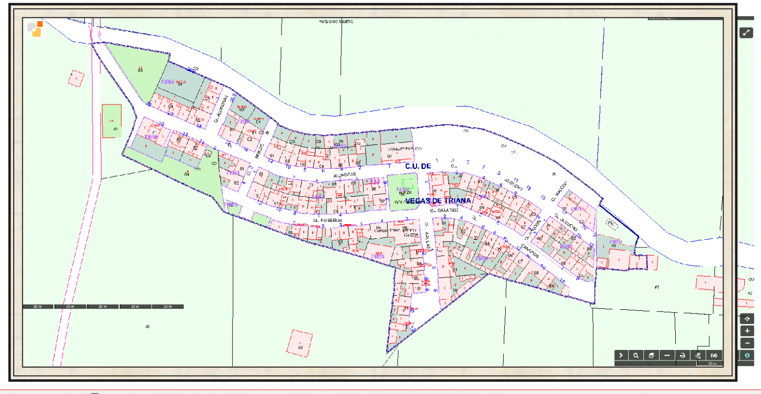
When i measure my map scale CC3+ shows a 597.1 m for a 100 m Scale, i select Non Visual Scale and i enter parameter of 100/597.1 but nothing change and the measure dosn`t change.
This is the map and the scale of the map.
Thank you for the help. <3
Comments
I don't generally use the non-visual scale tools, but did you give the scaling operation a "Scale Centre"? That's when you pick a spot just after entering the scale value. If you don't it won't scale.
If you keep an eye on the command line at the bottom of the screen you will be prompted for it.
i set scale centre on 0 as it shows the video
Okey i see that was the problem i was writting 0 and its 0,0; THX, my question is the size of the Canvas, i am working with Annual 5 1930 City, i set Canvas of 2600 X 1300 (i work with meters maps) but i think i am not understanding the size of the canvas... The size has relation with the Quality of the final resolution as for example is important in photoshop
Yes, it's a grid coordinate so you do need both zeros.
There's no actual canvas in CC3. You can export the very same map as an image that is 2000 x 2000 px, or 8000 x 8000 pixels. It's the same map, just exported at different sizes, or different resolutions as you prefer. The reason for taking care to draw everything 'to scale' within CC3 is so that all the sheet effects and drawing tools give you accurate and predictable outcomes as they have been set up in the template, and so that you can then measure distances and areas in your map within CC3 using the tools in the Info menu.
So you recommend waste time on adjust the scale for a CC3+ and Map scale perfect match ¿¿
The scale in CC3+ is important, as mapping to scale is what allows you to do things like import a drawing like you have here and scale it accurately.
I recommend having a read of this blog article which talks a lot about the importance of scale:
Wow that post is exactly what i need but i have some question, now i have my map proper scale i am using Annual Street city 1930 but drawing tools seems crazy, roads so big and those stuff. For example for a nice scale i should do a map size of 453x253 (meters units) but if i use Building Hatched, default (not the feet one i dont know his use) is oversize. I think maybe i should edit that drawing tool no ? Modify the fixed Width ??
This is the case, i highlighted on Red Building Hatched (Feet) (no idea his porpouse), Yellow Building Hatched, Default (Modifing Fixed width to 0.5) and on green Normal Building Hatched.
Thx for your patient
First of all, always use the metric/m versions of the tools, and not the feet/ft ones as the latter are intended for maps scaled in feet, and produce things that are scaled about 3 times larger.
The hatching will look a bit big, because you are using it on a rather small map. I think this style was designed with the intention that you do full city blocks in one go, not individual sections/houses like you do there.
It is fully possible to edit the hatching to make it smaller though, but it will take a few steps:
Changing things like widths of roads and rivers is simpler, because that is just a property of the drawing tool. All you have to do is to make a copy of an existing tool like in step 5 above, and then access BOTH the properties of your new tool, AND the Outline -> Properties and change the width settings there.
Note that drawing tools are system-wide and not map-specific, which is why I always advocate creating copies of tools rather than customize the originals. There's no reset to default button for these, and the ones supplied by PF may also be updated in a patch, invalidating your own changes, so making personal copies is the best overall strategy.
So i am using bad this annual ... well i did what you said is working perfectly i will look if i modify other drawing tool like small roads. Thank you for your help :D
Monsen and Loopysue thax for you help i think i finished the map and i think is pretty nice :D, here is it feel free for critizice
For a first map this is great.
Regarding your questions re scale; as mentioned always use real world dimensions for your maps, this is one of the things that confuses people coming from other graphics programs (me included when I first started), all the tools, symbols etc will behave properly and you will have a much easier time of it.
When you export your map, you can set the resolution and output size.
I have a new question, can i do a city map with 1930 travel guide of a map of 17000m x9600m, maybe my pc explode :S and i think the annual is nor prepared for that sizes maybe :S
It will probably end up being a bit slow by the time you finished it.
I recommend either:
@Loopysue i reduce the size to 7500 x 9000 now goes better, with the other size with 3 symbols starts laggin a lot, its sounds nice do anothers maps with more details
If you reduce the size of the whole city map then it won't be at the correct scale. Keep it at the correct size (1 map unit = 1m), but don't draw individual buildings. Draw whole blocks and leave out the details like back streets and paths.
Once that map is finished, start again with 4 or more districts of the city, mapping each of those smaller areas in greater detail so that these smaller maps cover the whole city in a jigsaw of smaller maps.
yes i know thats why i start from 0 and rescale everything(i just was testing). That option looks really nice but i dont trust on me for doing 4 maps with correct measures of every distritc anyway my PC wont support that size map.
Hi Tako,
As @Loopysue suggests, try drawing the map at the correct real world scale, i.e. 17000m x 9000m. Draw the river and main roads (dark blue on the Google export, then major roads (dark grey on the Google export), then the park lands. Fill in between these with the block tool and scale the fill up so you can see the hatching, I would try 100 x 100 and see how that looks.
I'm sure there is a live mapping video of how to create detailed maps from large scale one. Also, check the Tome, @Monsen explains the process there, although done for overland map, the process would be the same.
That scale, use color areas for things like mountains, forests, etc. Symbols wouldn't work.
Good Morning @jmabbott ;
Thx for your comments, maybe i explained wrong, I am using City Map 1930 Streep Map (i think this issue is not prepared for huge areas) i will use real sizes but instead a 17000 m city map (cause i think my AMD Ryzen 5 5600X 6-Core Processor, 3701 Mhz, 6 procesadores principales, 12 procesadores lógicos, 1060 GTX and 16 gb ram wont move it, in the first test with only 3 buildings zoom in and zoom out start laggin a lot,and with the other maps i always work with effects off cause if they are turned on lags all the time) so what i did is reduce to 7500 the area to do, but the scale is correct but less area.
I want to buy the tome i am saving money at first :D i will check living maps.
EDIT: I bought the tome XD i cannot w8 for that :D
I just tried a map of the same size using the early modern city annual and it has the same issues. I agree both of these styles are best suited to smaller maps, I probably wouldn't go much bigger than 5km x 4km - not from a performance POV on my end, more an aesthetic one and the amount of additional work required to make them look good (re-scaling fill styles, modifying drawing tools etc).
yes thats is what i would do but first i am doing the essentials tutorial, in Spain we have a saying that says " Don't start the house at the roof" hahahahaha i think fits perfectly to my situation.