

Creating a Template to simulate the Khorvaire Map
 db2000
Traveler
db2000
Traveler
Hi Folks,
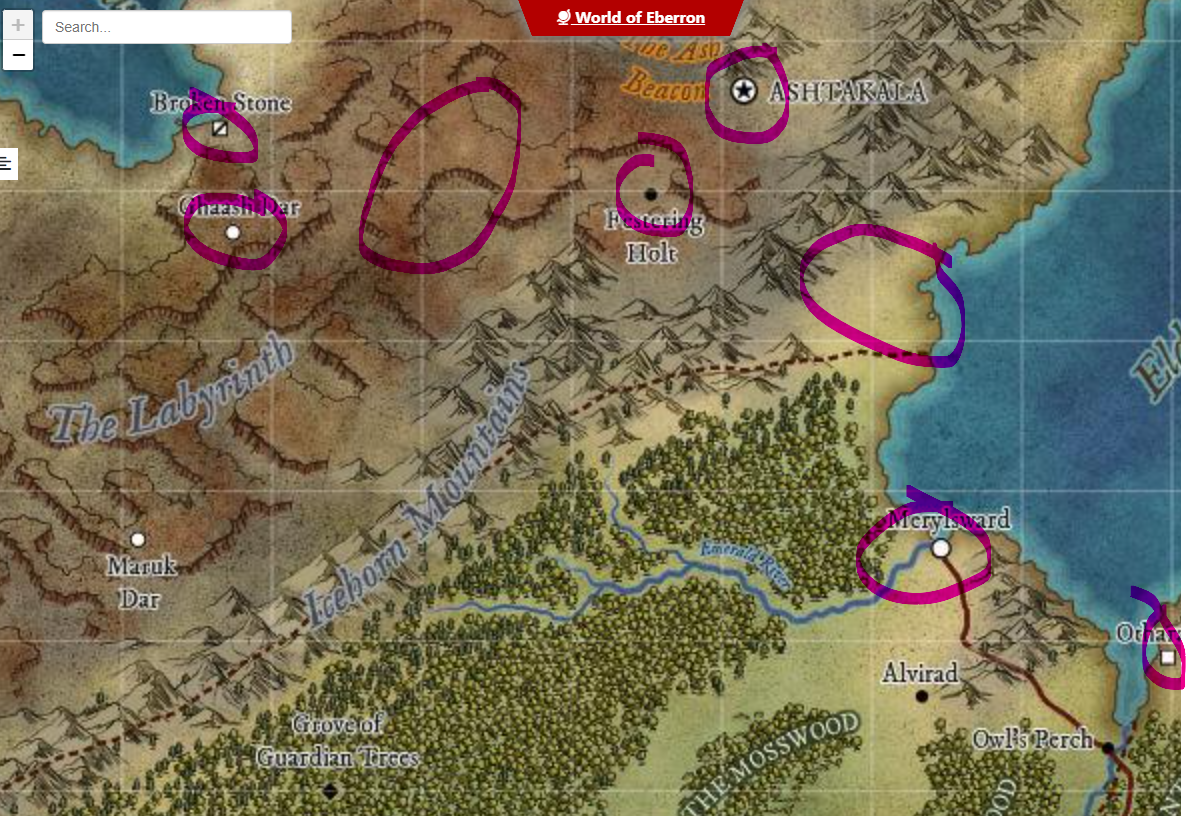
Been enjoying my time over the past few months getting used to CC3+ and am embarking on my first campaign map. I am trying to simulate the D&D Khorvaire map style (World of Eberron below) by creating my own template from existing resources. I am torn between 13th Age Revisted (2023) and Mike Schley for the map landmass style. I have also seen that the City symbols can be loosely emulated from the Modern Political style but am missing many symbols. Currently I am searching for the Square fort type of symbol to pull into the template along with the star that represents the capital cities. I guess what I am also seeking here is confirmation if I am on the right track, your opinions on the best style to simulate this and where I can find the symbols to import short of creating my own. Any help greatly appreciated ;0)


Comments
Since what you are looking for are essentially just simple markers, if you don't find what you are looking for elsewhere, you can easily just draw them yourself and define them as a symbol. See page 75 of the user manaul that shows step by step how to make a basic symbol marker like this (Or page 105 of the latest published version of the Tome, if you have that)
Many thanks Monsen, I'll take a look. Regarding the map style am I on the right track or are there better suggestions? Thanks
Have you got a screen shot of the map you've made so far, if you've started it yet?
Hi Sue,
This is just an initial play around -
How close a match to that original map are you hoping to get?
The reason for asking is I can make a few suggestions but none of the styles will exactly match that example. I don't want to go recommending a combination of lots of different styles from different annuals (which could get a bit expensive if you don't already own them), only to realise that it might have been ok to go with something less ambitious and a bit cheaper to do.
I currently own everything, so the expense is not an issue. below is the original Khorvaire landmass. I'm looking to have something similar only regarding two large masses in the centre loosley connected with several peninsulars and a few of archipelago's similar to my existing examples. There will be several important lakes, a few mountain ranges, one of which is made from black obsidian. There will also be a landmass that is artic. I don't want to create the same map as Khorvaire otherwise I may as well just import the outline and give it a new name bit I do want to create a dark themed setting with lots of scope for a lengthy campaign, if any of that makes sense lol.
Ok, that's good to know :)
For the landmass and ocean I recommend Darklands Overland style from the 2021 annual. Read the mapping guide for that one carefully since the sea goes on top of the land. That will give you a parchment land mass and will allow the different colours blended onto the land to extend right up to the coast despite being broadly blurred to give that soft colouration effect. there are set colours for the drawing tools, but you can clone and modify the drawing tools if you want different colours.
Once the land is put down and all the colours sorted out I think your ideas for the symbols are pretty good as it goes, though you might find it a little tricky matching them on a comparatively dark background like Darklands Overland. If that happens use the Mike Schley inks style and add a Blend Mode sheet effect to the symbols sheets set to Multiply to get rid of the white parts.
As for the structure symbols Remy has already explained those.
That leaves just the escarpment symbols. The closest I can think to that style is possibly the escarpments from the new E Prybylski Watercolor style in this year's annual, but they might not match that well.
Greatly appreciated. Looks like a challenge doing everything in reverse with land and sea but I will try that. Still a lot more to learn by the looks of things, but enjoying the journey and the company ;0)
The reversal of land and sea only happened because I wanted to be able to use very soft wide blends between colours on the land without having to obey the coastline.
It's actually the way water is usually done in a city map, so think of it as being an extremly large planetary city map.
EDIT: and if you get stuck at all just shout again. Things might not be as simple as I've described, or work the way I imagine they will, but we will get there in the end.
ok, thanks Sue. I'm pretty sure I will be shouting sometime soon ;0)
Hi Sue,
If I want to copy my existing land mass which is scaled at 2000w x 1500h in miles, what size do I need to make th emap I am copying to. The border effect you have interferes with the sizing slightly? Thanks
Ah yes, I'd forgotten about that little design flaw of mine.
I couldn't do it easily at the point of creation so I adjusted one by hand so that the centre area is 2000 x 1500.
The way this map is set up the border won't print if you crop to the map border when you export, so you can just ignore it, but if you want it you can export it with the rest of the map by using the Rectangular Section bitmap exports and including the frame in the selection you make.
Aah, thanks. I'll take a look and see what adjustments can be made.
If you want to use the land shape you've already drawn add a rectangle of ocean over the whole map first using one of the ocean drawing tools, then add your land shape to the same sheet and use the change properties tool to turn the fill of that shape to solid and magenta (colour 6). When you refresh the map that will cut a hole in the sea to reveal the land.
Then when you start adding the colour patches for the terrain you can draw them as far under the sea as you like and they will be masked by the water when you refresh the drawing.
(this is the point at which you might want to make some new drawing tools to add more orangey colours for the desert than the pinkish ones I did)
The coastal effects are controled by the sheet effects on the Water sheet. At the default settings they aren't really doing much on a map this size, and they are slightly wrong to match the style of the example anyway.
You will need to modify them like this:
Leave the Color Key as it is.
The first Glow effect should be something like this:
The second glow effect like this:
And the final Outer Glow effect like this:
I deleted the shadow effect.
EDIT: Even these aren't a brilliant match, but once you start editing them you will learn quickly how to adjust them yourself to get things working the way you want them to.
If you've worked out how to copy sheet effects from one map to another here is a second FCW file with those water sheet effects on it.
LOL, you must have read my mind. I have been experimenting for the past hour, first creating an additional land sheet and trying to figure out how to cut the sea out. Very much appreciate this info.
No problem. I do tend to continue thinking about things. It's a sort of natural progression of thought.
When you get as far as adding symbols there may be a problem with getting rid of the white bits, but there are at least two ways around that.
I have to go out for a little while right now, so I'm hoping I've given you enough to be getting on with for an hour or two.
I'll need to carry on tomorrow but greatly appreciate the help. Thanks
If you get stuck and I'm not around there will undoubtedly be help from others. I'm not the only person who can work this out with you :)
I managed to ammend the original land masses and port across what I think is now correct (see below). The current problem is with the political borders. Previously these were hollow with an edge effect as per image 1 but I can't replicate this on the new map as they come out solid. I assume this is because although they are political borders they need to be on a different layer to Borders/Political so that correct sheet effects can be applied?
Don't start moving them, just yet, and check you have sheet effects turned on.
They're on the correct layer, though layers don't have anything to do with the way something appears on the map. It's the sheets and their effects that are more important.
When you move something like this it will create it's own new sheet if that named sheet didn't exist in the new map to start with, but it's created without any effects. Or, if the named sheet was already there it will have it's own effects that may not do quite the same thing.
Find out which sheet they are on by using List in the Info menu, then check the effects on that sheet. If there are any there delete them and copy the effects across from your older map using the copy and paste buttons to the right of the effects panel once you have highlighted them all. You will have to have both maps open at the same time to do that, but you can open the older map by double clicking its file icon without causing your new one to close.
EDIT: I notice that you have hidden the SCREEN. That leaves the bright green map border (the one that CC3 uses to define exports) visible around the edge. It might be a good idea to show the SCREEN sheet, but to use change properties on it to turn it solid white if you want there to be a white border around the edge as shown in your picture above. I think I froze the SCREEN layer that its on, so to work with it you will have to unfreeze the layer. Refreeze the SCREEN layer once you are done with it. Doing that will give you the white border without the green line.
That worked, thanks Sue. Forgot about the copying the effect over. In your effects all of them are ok except for blend mode which is set to multiply mode at 100% opacity. I have changed this to 35% for when I want complete territory saturation colours and switch it off when not needed to just keep the outer edge, which is just an edge fade set to 1.5 units at 8% opacity using percent of drawing extent width.
This afternoon I just need to figure out if I will run into issues creating the borders on the new map, given some things are done in reverse lol.
There are 2 parts to the 'frame' around the map. The first is the SCREEN, which I mentioned in my edit above. This is a relatively important part of the map even if you turn it white because it will neatly conceal any mountains or land colours that extend beyond the edge of the drawing.
The other part of the visible frame is currently occupied by the ribbon polygons. The ribbons can be deleted if you want to replace them with something else, and the effects on that sheet modified accordingly.
Both of these sheets are drawn after everything else in the map and on top of the whole lot, so they shouldn't be affected by the way the water is on top of the land.
Yes thanks, I saw these. I temporarily hid them but will activate them at the end. The borders I was referring to was the political borders for the new land masses as I have only done a few so far on the old map and none on the new map other than what was copied across.
Oh yes, I see. I got the wrong end of the stick again. Sorry!
In answer to the actual concern you have about the regional borders - you should be able to draw them and trace the coastline just as before. The trace tool will pick up the edge of the cutout polygon as easily as it picked up the land polygon in your earlier map.
Wow, great technique. Didn't know this one.
When Drawing Land/Ocean in reverse, do you sometimes use several pieces/patches of ocean?
Thanks :)
You can if you want, Hadrian, but it's easier to put a whole rectangle of sea over the map and cut holes in it making use of the Color Key effect on the WATER sheet.
It's not really an original idea. Most city map styles have the water over the land. It's just an adaptation of that for overland maps.
I think I haven't used the color key effect ever. Not sure how it works.
I did lakes and so one on city maps, but then when I would do Islands I created them on top of the lake, not cut them out.
The best way to see how it works is to open a drawing and add a Color Key effect to a sheet that has a polygon you want to cut a hole in. Add a Color Key sheet effect to that sheet, noting the cutout colour (magenta or colour 6 by default). Then draw a magenta poly representing the hole you want to cut on the same sheet as the poly you want to cut the hole in (the one with the Color Key effect) and hit refresh. I didn't understand it to start with, but trying it out suddenly started a whole lot of little sparks in my mind as I saw what I could do with it.
A Color Key will also cut holes in city symbols, though not in symbols in overland or dungeon maps. It works like an inverted mask.
@db2000 - sorry for hijacking your thread just a bit there!