

Issues with Inked Ruins Style: Hatching "Texture" Size and Water Rendering

Dear fellow forumites:
I'm working on a map in the new Inked Ruins style, but I'm facing two issues:
When I try to use the terrain fills (on Metric) and Wall drawing tools, the size of the fill items is about 3 times too large. Walls are also far too thick. I've worked around the issue by creating another map in the same style with 3 times the size, in which I create trace the terrain fills. Then I copy them back into the original map, which is a bit cumbersome. Could this be an issue with the scaling of the "metric" style?
Drawing bodies of water that touch the map edge creates render issues. Samples:
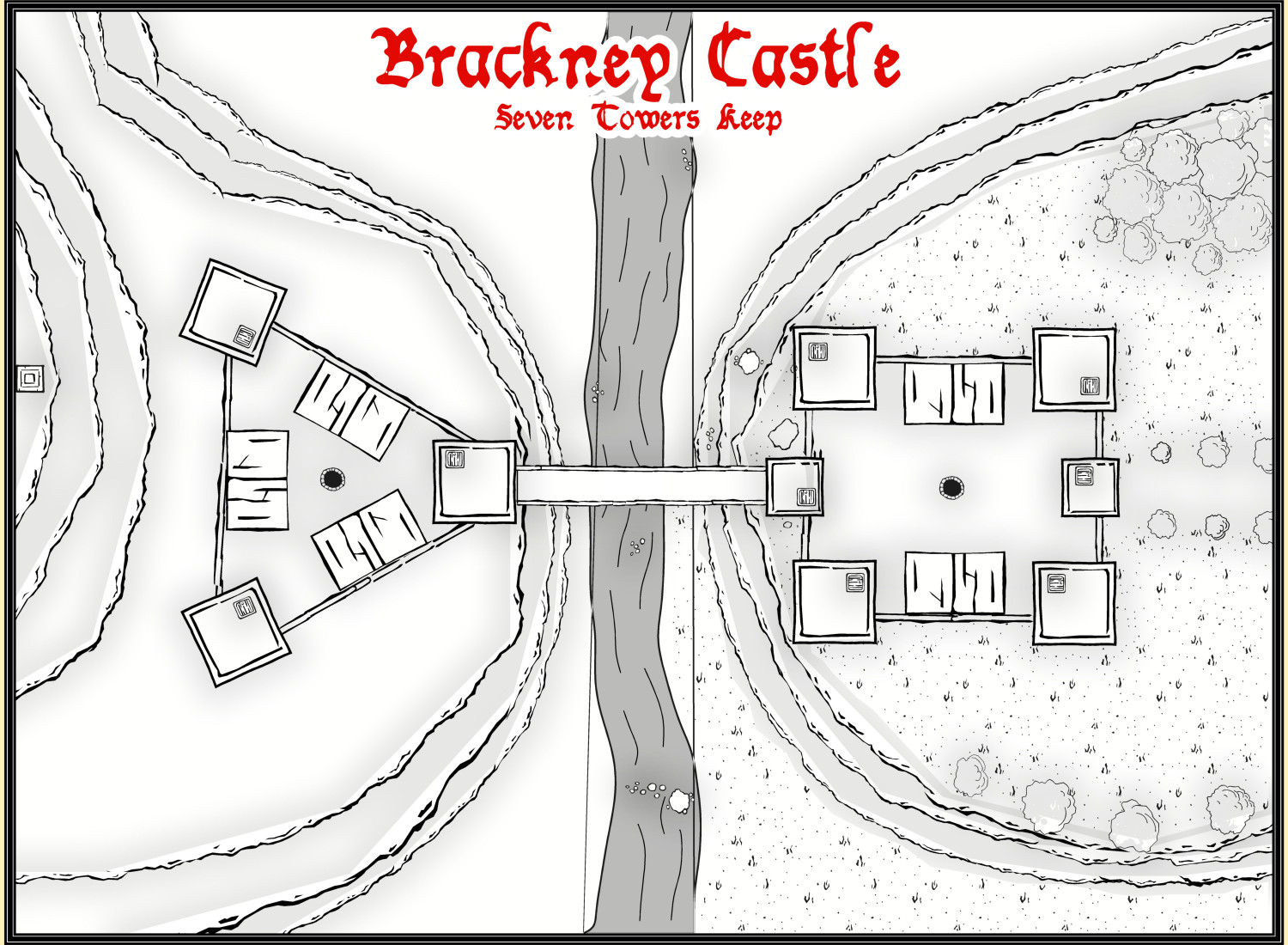
Central river rendered as one body of water: See the vertical lines touching the river.
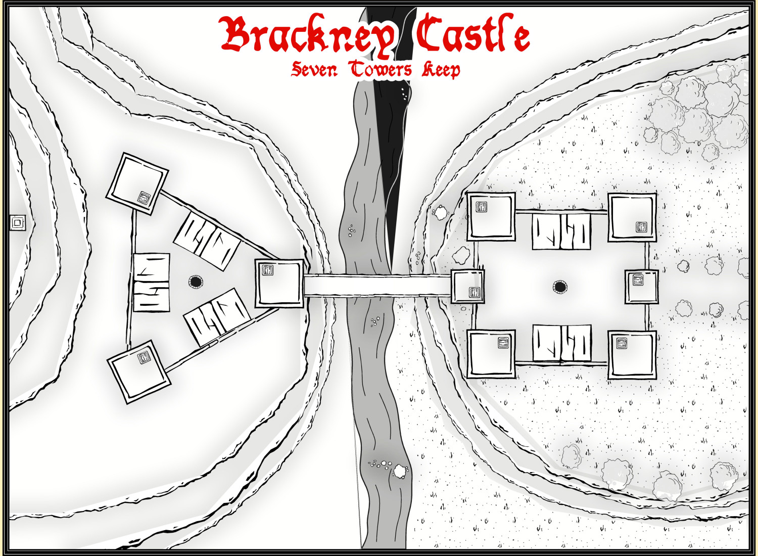
Second attempt: Central river deleted and rendered as two separate bodes of water, with the "gap" inbetween hidden under the bridge:
What can I do to solve these problems? If it helps, I can provide the FCW file.


Comments
Hi Eukalyptus :)
I think Ralf may need to have a look at that first issue at least, if not the second one as well. The FCW file might be a good start, but I would send it as part of a Tech Support request so it gets a ticket in case any of the rest of the team get to it first, since Ralf is at Gen Con right now.
You could also post the FCW here in case anyone else might have an idea how to solve that artefact issue in the meantime.
The water lines problem looks to be one of the classic issues with too many nodes too close together, in this case because the water drawing tool is set to not extend beyond the map border, and as a smooth drawing tool, it will automatically put a pair of "Corners" at the map border to create the straight line there. A Corner is basically three nodes very close together.
A quick check suggests you should be able to solve this by using the "Advanced" button for the water drawing tool, unchecking the "Restrict to map border" box and then save the tool. Then redraw your river, making sure you draw the ends a little way beyond the top and bottom map edges. DO NOT use the "C" = "Corner" option, just add a few nodes and make the ends of the river outside the map border a bit more rounded, with fewer nodes close together. The screen should hide this once you're done (or if not you can use the COLLAR commands to create a new, larger one - use COLLARDEL first to remove the existing screen, and then COLLARAUTO to add a new one - if I've remembered that right).
Hopefully, that'll cure this point at least. Good luck!
It worked. and now I' also know about the advanced drawing tool options and the ability to turn "Restrict to Map Border" off, which'll help a lot in other styles. Thanks a lot, Wyvern. 🙂
In regards to the Fill Issue, there seems to be no separate "Metric" Style in the Drawing Presets:
But the drawing units are set to meters, which looks correct.
Here's the FCW if anyone wants to take a look.
I'll prepare the support request - while probaly finishing the map using the workaround.
You're very welcome Eukalyptus! Glad it helped.
Turning off the "Restrict to map border" command was one of the first things I discovered, because it solves so many problems with the effects, such as when you've applied something like an edge fade (or other similar techniques) to a fill, to avoid getting those round the map border too, creating a border within the border, which almost always looks wrong. When I remember now, I usually turn it off in all tools I know I'll be using, because it's just so annoying sometimes. I understand why it's turned on as the default, although for someone who often works outside the technical map border - to add map keys, for instance - aside from with on-map features that don't benefit from a sharp map-border edge - it's a real pain. Appreciate I may not be typical in this though 😊!
i also turn off ALL my "Restrict to map border" options where im working.
Rivers, roads, land mass, default terrain etc.
For me its more easy and fast to work. Then i clear outside map using collarw comand.
Makes sense - now that I know how to do it.
I had gotten used to using the "Extract Properties" on an existing road / terrain patch etc and then creating manual lines and shapes, but It's much better to turn the map border restriction off right away.
Support request for the hatch / line size has been sent.